Skip to content
Daingerfield State Park in Texas

Piney Woods · State Parks

Daingerfield State Park

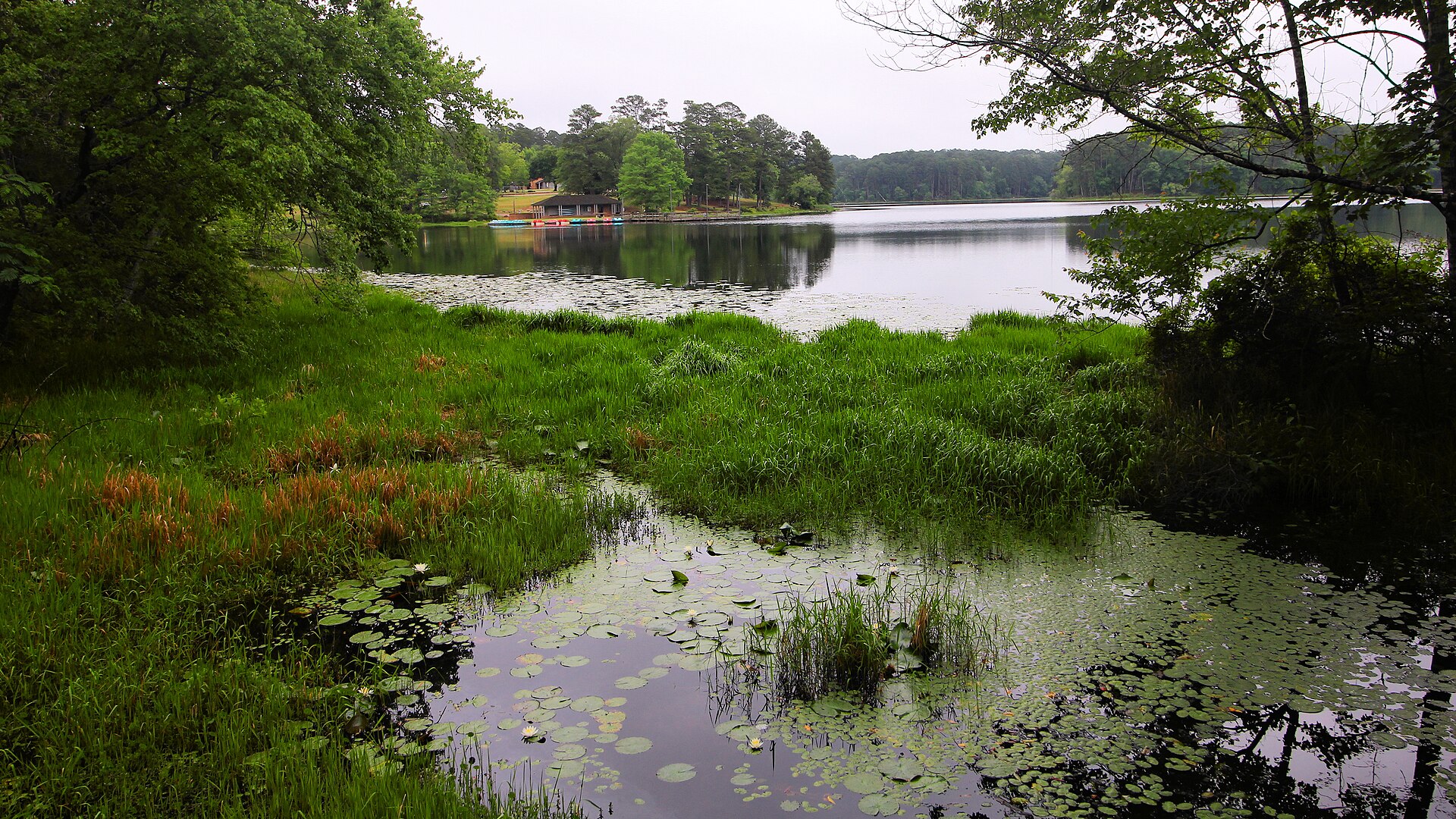
A small East Texas park wrapped around an 80-acre lake, with tall pines, hardwood forest, paddling, fishing, swimming and one of the state's classic CCC landscapes.

Photography: Larry D. Moore · CC BY 4.0 · Wikimedia Commons

Quick trip facts

Daingerfield State Park at a glance

Where is Daingerfield State Park?
Daingerfield State Park is at 455 Park Road 17, Daingerfield, TX 75638, in Morris County.
When is the best time to visit Daingerfield State Park?
Fall through spring for trails and camping; summer for swimming
Do I need to plan ahead for Daingerfield State Park?
Daingerfield displayed an active TPWD park-alert banner on October 17, 2026, but the alert details could not be independently retrieved. Verify current access before reserving cabins, paddling equipment or camping.
Who manages Daingerfield State Park?
Texas Parks and Wildlife Department

The experience

Visiting Daingerfield State Park

Daingerfield State Park is built around 74-acre Little Pine Lake under dense Northeast Texas pine and hardwood forest. The setting lends itself to a quieter combination of walking, fishing, paddling and a lakeside overnight stop rather than a full-scale motorboat trip. TPWD notes a 5-mph limit on lake boats and offers a fishing pier, boat ramp and a variety of rentable paddle craft. Fishing rules and seasonal rentals need checking for the specific visit.

Choose a trail by terrain rather than mileage alone. The 2.4-mile Rustling Leaves Trail circles the lake and is described as an easier park walk, while the shorter 0.8-mile Mountain View Trail climbs to a high point. Forest shade is not a substitute for water or heat planning during summer, and surfaces can be slick after rain. TPWD identifies the park as a spring-wildflower and autumn-color destination, with birding possible throughout the year.

The Civilian Conservation Corps history gives Daingerfield a second point of interest beyond the lake. CCC crews built the dam and facilities including Bass Lodge, the group hall and pavilion. Today the park has a mix of individual campsites, historic cabins and group facilities; it is essential to distinguish a Cedar Ridge tent-only site from a Big Pine full-hookup pull-through or a staffed rental cabin. The store and equipment rental desk run on their own schedules.

TPWD's main visitor guide reported an active-alert banner on October 17, 2026, but the linked alert was unavailable to independently verify the exact restriction. No claim of fully open trails, unrestricted fires or guaranteed rentals is made here. Before travel, check directly with TPWD and make sure the chosen campsite or cabin is still in service. The primary entrance is on Park Road 17 east of Daingerfield, and drivers should choose the correct campground after entering.

The details

Planning your visit

Area
Daingerfield, Texas
Best season
Fall through spring for trails and camping; summer for swimming
Address
455 Park Road 17, Daingerfield, TX 75638
Entry & reservations
Daingerfield displayed an active TPWD park-alert banner on October 17, 2026, but the alert details could not be independently retrieved. Verify current access before reserving cabins, paddling equipment or camping.

Texas State Parks · trip planning

Park entrances, facilities and visitor maps

Amenities can differ by park unit, campsite and season. The details below are park-specific where checked against TPWD. For changing hours, reservations, trail conditions and facility availability, use the park's official visitor resources.

Restrooms and showers
TPWD lists nearby restrooms for both Big Pine full-hookup campsites and Cedar Ridge tent-only campsites. Amenities differ by campground; do not treat the park map as a single shared camping loop.
Parking, entrance and access
The park entrance is on Park Road 17 off Highway 49, east of Daingerfield. Use TPWD's park map for lakefront, trail and camping parking zones.
Camping, RV hookups and drinking water
Big Pine has full-hookup pull-through and back-in campsites with nearby restrooms; Cedar Ridge offers tent-only sites with water and nearby restrooms. Check the selected category before booking.
Trails, parking and visitor maps
TPWD publishes separate park and trails maps.
Access restrictions and current visitor rules
TPWD currently lists gate hours 6 a.m.–10 p.m.; park office and park store follow shorter schedules, so check them before arriving for equipment or supplies. TPWD's visitor guide identifies 74-acre Little Pine Lake, a 2.4-mile Rustling Leaves loop, a 0.8-mile Mountain View Trail, historic CCC-built Bass Lodge and group hall, and 5-mph boating. It lists licensed exemptions for fishing within park boundaries and several kinds of rentable paddle craft. An active-alert banner was visible October 17, 2026, but alert details could not be independently read; contact the park before treating trails, rentals, or camp areas as open.

Park-specific visitor facts checked 2026-10-17 against the TPWD source. Additional campsite or day-use details: official TPWD facilities record. Additional official TPWD reference: TPWD source page.

Explore Texas state parks

Upcoming TPWD programs

Activities scheduled at this park

These dates come from the Texas Parks and Wildlife calendar. Check the official listing for registration, meeting place, admission and any changes.

Browse upcoming TPWD programs statewide →

Practical questions

Frequently asked questions about Daingerfield State Park

Is Little Pine Lake a large motorboating lake?
No. It is 74 acres, and TPWD sets a 5-mph speed limit. Fishing, low-speed boating and paddling are featured.Check official details ↗
What hikes can I do at Daingerfield?
TPWD describes the 2.4-mile Rustling Leaves lake circuit and a steeper 0.8-mile Mountain View Trail.Check official details ↗
Are all Daingerfield facilities open?
TPWD flags an active alert, but detail could not be independently read October 17, 2026. Ask the park before booking a particular cabin, trail or rental.Check official details ↗

Plan the route

Explore related places

Editorially paired stops near Daingerfield State Park appear first, followed by nearby destinations. Distances are approximate straight-line miles.

  • Omaha · Bowie, Cass, Morris and Titus counties · Piney Woods

    White Oak Creek Wildlife Management Area

    White Oak Creek WMA protects about 25,777 acres of bottomland hardwood forest at the confluence of the Sulphur River and White Oak Creek across Bowie, Cass, Morris and Titus counties.

    Best season: Fall through spring for cooler hiking and wildlife viewing; avoid high-water periods when heavy rain floods bottomland access.Updated Sep 2026
    • 25,777 acres of bottomland hardwoods
    • Sulphur River and White Oak Creek confluence
    • Fishing and horseback riding
    Explore this place

    Approx. 11 miles away

  • Pittsburg · Camp County · Piney Woods

    Northeast Texas Rural Heritage Museum

    Pittsburg's Northeast Texas Rural Heritage Museum combines a historic railroad depot and farmstead to interpret Caddo history, railroads, rural technology, agriculture, domestic life and the famous Ezekiel Airship story of Camp County.

    Updated Aug 2026
    • Historic Pittsburg depot
    • Ezekiel Airship replica
    • Farmstead museum
    Explore this place

    Approx. 16 miles away

  • Mount Pleasant · Titus County · Piney Woods

    Titus County Museum

    Titus County Museum inside Mount Pleasant Public Library interprets the city and county through artifacts and interactive environments spanning Caddo history, settlement, the Civil War and later community life in Northeast Texas.

    Updated Sep 2026
    • Walk-in Caddo grass-hut interpretation
    • Civil War camp and Titus County service history
    • Log-cabin environment and settlement context
    Explore this place

    Approx. 19 miles away

  • Approx. 23 miles away

  • Jefferson · Marion County · Piney Woods

    Jefferson

    Jefferson is an East Texas riverport town whose brick streets, preserved nineteenth-century buildings, museums, historic homes and Big Cypress Bayou setting make it one of the state's strongest walkable heritage destinations and a natural gateway to Caddo Lake country.

    Best season: Fall through spring for comfortable walking; spring brings major heritage events, while summer is greener but hotter and more humidUpdated Sep 2026
    • Jefferson Historic District
    • brick streets
    • Jefferson Historical Museum
    Explore this place

    Approx. 27 miles away

  • Atlanta · Cass County · Piney Woods

    Atlanta State Park

    A peaceful pine-and-hardwood retreat on Wright Patman Lake for fishing, boating, swimming, camping, and birding.

    • Fishing
    • Boating
    • Swimming
    Explore this place

    Approx. 30 miles away

Read next

More from State Parks

State Parks

Down Into the Panhandle

A complete first-timer’s guide to the Lighthouse Trail at Palo Duro Canyon: distance, heat, water, timing, the final climb, and how to make the canyon a full day instead of one photograph.

August 20, 2026 · About 8 minutes

State Parks

The Texas State Park You Should Start With

There is no single best park. There is a best first park for the kind of Texas you want to understand — canyon, coast, granite, forest or river.

August 7, 2026 · About 3 minutes