

The short answer
What exactly is Davis Hill?
Davis Hill is a state-owned conservation property northeast of Houston along the Trinity River in Liberty County. TPWD acquired it in 1983 and has described it as approximately 1,700 acres. It is part of the state parks system, but not a developed, routinely accessible state park. The agency's current future-parks list calls it Davis Hill State Natural Area; older commission records sometimes call it Davis Hill State Park.
This matters because a similarly named but entirely different park, Davis Mountains State Park, is open near Fort Davis in West Texas. Its trails, Indian Lodge, mountains, fees, directions and photographs do not describe Davis Hill.
Geography
Where Davis Hill sits — and why that matters
The property occupies high and low terrain close to the Trinity River in Liberty County, roughly 40–45 miles northeast or east of downtown Houston as described in different TPWD proceedings. In a TPWD interview, natural-resources coordinator Andy Sipocz locates it upstream of Liberty, near Tarkington Prairie. This is the humid upper Texas coastal plain, not the Trans-Pecos desert.
The site stretches from unusually elevated coastal-plain ground toward bottomland forest, swamp, and river-edge sand. The dramatic change in elevation over a relatively short distance creates different habitats. Map markers for the property describe its geography only; they do not represent a public gate, legal road easement, trailhead, or put-in.
Explore Liberty County's geography and history or read how Texas rivers shape surrounding land.
Geology explained
How a salt dome made a hill in a flat coastal plain
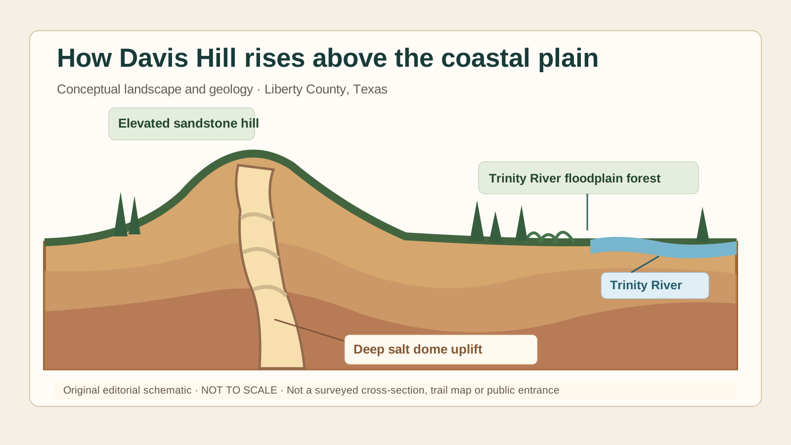
The defining landform is a salt dome: deeply buried salt moves upward under pressure, deforming the rock above it. At Davis Hill, TPWD's natural-resources interview describes sandstone pushed up to roughly 280 feet above sea level. That figure is from agency interpretation of the hill's summit, not the elevation of the park boundary, a public overlook, or a published climbing route.
This unusual rock-and-slope environment is a contrast with the low, flood-prone Trinity River bottomlands. Different soil, drainage, shade, and moisture conditions help explain why the hill and river margin support such different plant communities within one relatively small conservation area.
Habitat and conservation
Why biologists consider Davis Hill exceptional
At the 2022 Texas Parks and Wildlife Commission meeting, TPWD staff described Davis Hill as having the highest number of plant associations per acre in the state park system. That is the agency's characterization from that meeting, not a newly calculated TexasDefined ranking. Its juxtaposition of sandstone upland, slopes, ravines, bottomland hardwoods and wetter Trinity River habitat helps explain the diversity.
TPWD's 2023 conservation overview specifically identifies the uncommon shadow witch orchid in clay-soil ravines, alongside cypress, ferns and little bluestem. It also reported two potentially undescribed plant species under study at that time. These are scientific conservation details, not a guarantee that visitors can view or photograph the plants; sensitive species locations should not be publicized.
Protecting fragmented habitats and reducing land-management conflicts helps make sense of TPWD's interest in strategic adjacent parcels and inholdings. More habitat does not automatically mean more immediate visitor access: management, legal access and habitat protection must be planned together.
Texas history
Who was Davis Hill named for?
TPWD names the site for General James Davis, whom it identifies as a veteran of the War of 1812 and the Army of the Republic of Texas. TPWD says Davis had a plantation home atop the hill. That history is part of the landscape's story, including the plantation era; our current primary records do not establish a visitor-accessible historic structure or interpretive tour.
The department acquired Davis Hill in 1983. It remained largely undeveloped for decades. The site is therefore relevant both to cultural history and to the history of Texas conservation: the state can protect land long before it has the road access, facilities, staff and funding needed to open it safely for routine public use.
Documented chronology
From acquisition to future-park planning
1983
Land acquired
TPWD acquires the Davis Hill holding; subsequent agency accounts describe a property of roughly 1,700 acres. Primary record.
2013
Interest in limited access
Public testimony at a commission hearing discusses local conservation work and hopes for limited access, not an opening announcement. Primary record.
March 2022
Land-acquisition strategy advanced
Commission materials authorize pursuing inholdings and neighboring tracts, about 50 acres in total, from willing sellers. Authorization is not proof that every parcel was acquired. Primary record.
2023
Future-site program documented
TPWD lists Davis Hill among six properties slated for future park or natural-area development; its magazine reports that access remains unresolved. Primary record.
2025–October 2026
Designation and access checked
The 2025 TPWD inventory uses the historic State Park designation, while the current future-parks page calls it a State Natural Area. Neither presents a routine visitor opening. Primary record.
The chronology distinguishes authorized negotiations from completed purchases, and a planned future park from an announced opening. Dates are dates of source material, not evidence of an opening date.
Practical planning
What visitors should — and should not — plan
The correct travel advice is not to make Davis Hill a driving destination yet. The TPWD future-parks page provides no operating park entry, reservation portal, visitor center, public trail map, campground or opening schedule for Davis Hill. The 2023 official overview explicitly described it as inaccessible while the agency worked on land access.
Do not use third-party pins, aerial photographs, private roads or the riverfront as permission to enter. Do not attempt to reach the property through neighboring land or assume a canoe landing is open. Visitors looking for an actual outing can compare operating Texas state parks below and confirm each park's alerts directly with TPWD.
- Lake Livingston State Park — a developed lake-centered state park in this broader region.
- Village Creek State Park — a public forest-and-creek park in Southeast Texas.
- Sheldon Lake State Park — a Houston-area alternative for wetlands and wildlife.
For statewide choices, visit the Texas state parks guide. These are alternatives, not routes or access points into Davis Hill.
Clear answers
Frequently asked questions
Is Davis Hill State Park open to the public?
No general visitor access is advertised. TPWD lists Davis Hill State Natural Area under future parks and its detailed overview says the property was inaccessible while the agency pursued access. Do not attempt to enter private land or treat a map pin as a public entrance.
Where is Davis Hill?
Davis Hill lies in Liberty County northeast of Houston, near the Tarkington Prairie area and the Trinity River. It is not in Fort Davis or the Davis Mountains of West Texas.
Can I hike, camp, fish, or reserve a campsite?
There is no published ordinary visitor entrance, trail system, campsite booking or day-pass program for Davis Hill. The Trinity River frontage described by TPWD does not establish a public launch or legal shore access.
When will Davis Hill open?
TPWD has not announced a verified opening date in the agency materials reviewed on October 20, 2026. Land access, resource protection, planning, funding and construction are separate steps, so old estimates should not be treated as a schedule.
Is Davis Hill the same as Davis Mountains State Park?
No. Davis Hill is a future natural area in Liberty County in Southeast Texas. Davis Mountains State Park is a developed and operational mountain park near Fort Davis in Jeff Davis County, hundreds of miles west.
Editorial method
Sources, methodology and limits
This independent guide prioritizes original Texas Parks & Wildlife Department commission agendas, transcripts, published natural-resource interviews, the official future-parks roster and the agency's conservation reporting. Historical records are dated so a proposal is not accidentally presented as completed work. This page deliberately does not show a claimed on-site photograph or public entrance map: neither was independently authenticated for publication as visitor information.
As of the review date, there was no verifiable opening date, published general-access trail system or bookable campsite information for Davis Hill. Any later change should be rechecked against current TPWD material before this page's access guidance changes. Texas Defined is not affiliated with TPWD.
Primary-source reading list
- 1.TPWD — Future Parks (current development roster)
Current agency classification: Davis Hill State Natural Area is a future-development holding, not an operating visitor park.
- 2.TPWD — Commission land-acquisition agenda, March 24, 2022
Acquisition date, approximate area, location, James Davis history and the proposed acquisition of about 50 acres.
- 3.TPWD — Commission meeting transcript, March 24, 2022
Firsthand staff testimony about plant diversity, inholdings, access and conservation.
- 4.TPWD Magazine — State Parks on the Horizon (2023)
Davis Hill's inaccessible status as published, vegetation, rare plants, a TPWD photograph and the agency's development discussion.
- 5.TPWD — Wanderlist audio transcript: Future State Parks
Natural-resources staff explain the salt dome, sandstone uplift, Trinity River habitat and local geography.
- 6.TPWD — Six State Parks on the Horizon, May 2, 2023
Agency announcement identifying Davis Hill as one of six future sites.
- 7.TPWD — August 20, 2025 work-session agenda
Later official statewide inventory using the historic 'Davis Hill State Park' designation and Liberty County location.
Last independently reviewed: . Suggested citation: Texas Defined Editorial Desk, “Davis Hill State Natural Area: Access, History & Geology,” texasdefined.com/destination/davis-hill-state-park (accessed October 20, 2026).