Texas Explained
Texas Ecoregions: Complete Map & Guide to All 10 Natural Regions
A map-first guide to all 10 major Texas natural regions, from Piney Woods and coastal marshes to Blackland Prairie, Hill Country, High Plains and the Trans-Pecos, with landscapes, vegetation, wildlife and places to experience each one.
Texas is not one landscape. It is a meeting place for southeastern forests, tallgrass and mixed-grass prairies, limestone plateau country, subtropical thornscrub, High Plains grassland, coastal marshes and Chihuahuan Desert mountains. Texas Parks and Wildlife commonly organizes that diversity into 10 major natural regions. Those regions are a useful first layer for understanding the state's plants, wildlife, soils, water, agriculture and even the way long road trips feel from the windshield.
The boundaries are ecological rather than political. They do not stop at county lines, and transition zones can be broad. A ranch, park or city can sit near an edge where characteristics of two regions overlap. Use this guide for statewide orientation, then use site-specific soil, hydrology, vegetation and management information when a precise parcel or habitat decision matters.
How to read the Texas ecoregions map
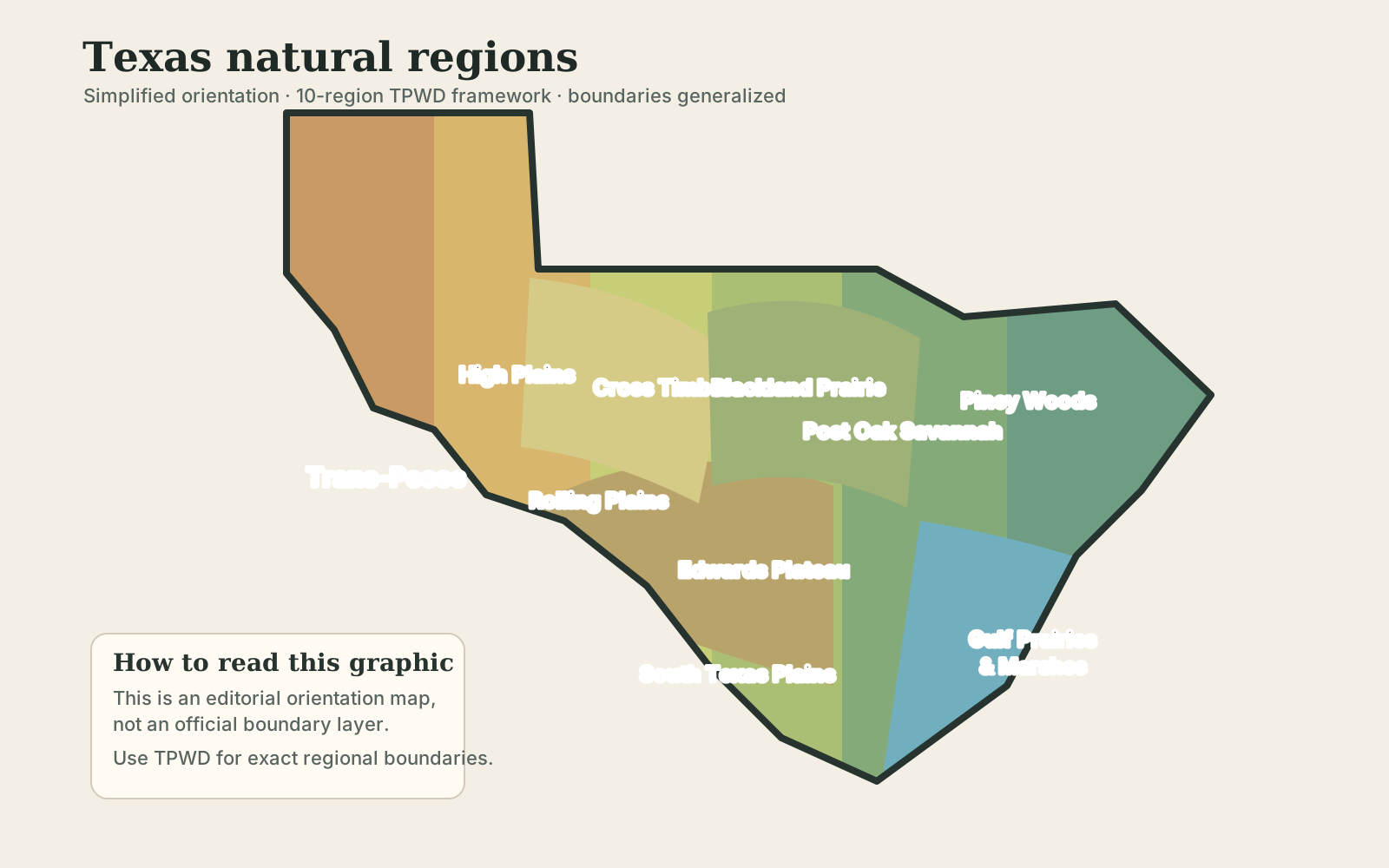
The map above is a TexasDefined orientation graphic based on the Texas Parks and Wildlife 10-region framework. Its boundaries are deliberately generalized rather than survey-grade. Use it to understand the statewide pattern, and use the linked TPWD source whenever exact regional boundaries matter.
The broad pattern is clear: wetter forests dominate the east; prairie and savannah systems occupy much of the center; limestone plateau country rises through Central Texas; South Texas becomes hotter and brushier; the Panhandle and northwest open into plains; and the Trans-Pecos becomes true desert-and-mountain country.
The 10 Texas natural regions at a glance
- Piney Woods — humid East Texas forest, bottomlands, pine and hardwood communities.
- Gulf Prairies and Marshes — coastal prairie, wetlands, estuaries, bays and barrier-island systems.
- Post Oak Savannah — oak woodland and savannah transition between East Texas forest and interior prairie.
- Blackland Prairie — dark clay soils and former tallgrass prairie through a heavily developed and farmed central corridor.
- Cross Timbers — alternating belts of oak woodland and grassland across north-central Texas.
- South Texas Plains — thornscrub, mesquite, grassland and ranch country adapted to heat and variable rainfall.
- Edwards Plateau — limestone upland, karst, springs, live oak, juniper and the Hill Country's dissected eastern edge.
- Rolling Plains — red soils, grassland, shrubland and broken plains east of the Caprock.
- High Plains — elevated, broad and often very flat tableland of the Panhandle and South Plains.
- Trans-Pecos — Chihuahuan Desert basins, mountain ranges, desert grasslands and high-elevation woodland in far West Texas.
1. Piney Woods
The Piney Woods occupy the humid eastern edge of Texas and connect ecologically with the forests of Louisiana, Arkansas and the broader Southeast. Higher rainfall supports loblolly and shortleaf pine, hardwoods, bottomland forests, baygalls, wetlands and longleaf-pine remnants. The landscape can feel almost un-Texan to visitors whose mental picture of the state is prairie, ranchland or desert.
Water is a defining feature. The Sabine, Neches and their tributaries cross forested country, while floodplains, bayous and sloughs create habitat for amphibians, reptiles, wading birds and wetland plants. White-tailed deer, eastern wild turkey, squirrels, woodpeckers and many migratory birds are characteristic wildlife, though no species belongs to only one ecoregion.
For a public-land introduction, Big Thicket National Preserve is especially useful because it protects a mosaic of pine savannah, hardwood forest, wetlands and bayous rather than one single forest type. The region is also central to Texas timber history and modern forestry.
2. Gulf Prairies and Marshes
The Texas coast is much more than beach. Inland from the Gulf are coastal prairies, wetlands, marshes, bays, estuaries and low-gradient drainage systems. Barrier islands and peninsulas form another layer seaward. Elevation is low, soils can be poorly drained, and saltwater, freshwater and brackish systems meet across short distances.
This region is nationally important for migratory birds because the Texas coast lies on major migration routes. Estuaries and marshes also serve as nursery habitat for fish, shrimp, crabs and other aquatic life. Hurricanes, storm surge, subsidence, river inflow and wetland loss are not side issues here; they are central forces shaping the landscape.
Galveston Island, the upper coast, the Coastal Bend and the lower coast each look different, but all make more sense when viewed as parts of a linked coastal system rather than as isolated beaches.
3. Post Oak Savannah
The Post Oak Savannah forms a broad transition between the wetter Piney Woods and the interior prairies. Historically it mixed grassland with open woodland and scattered post oak and blackjack oak. Sandy or loamy soils and repeated disturbance helped maintain a patchwork rather than one continuous forest.
That transitional character is the key to understanding it. Travel west from East Texas and the forest canopy begins to open. Travel east from the Blackland Prairie and woody cover becomes more persistent. Fire, grazing, clearing and modern development have altered the balance, so many present-day landscapes are woodier than their historical condition.
Because this region overlaps the fast-growing Texas Triangle, surviving natural communities often sit beside farms, ranches, reservoirs, towns and expanding metropolitan edges.
4. Blackland Prairie
The Blackland Prairie is named for its dark, fertile clay soils. Historically, tallgrass prairie dominated much of the region, but those productive soils also made it one of the most heavily cultivated parts of Texas. Urban growth later added another layer of change, especially along the Dallas–Fort Worth, Waco, Temple and Austin–San Antonio corridor.
Prairie does not mean empty land. A healthy grassland is structurally complex, with deep-rooted grasses, seasonal wildflowers, insects, ground-nesting birds and soil processes that differ sharply from a mowed field or cropland. Remnant prairies are therefore disproportionately valuable because so much of the original system was converted.
For travelers, the Blackland Prairie is often easiest to notice where preserved grassland sits beside developed or agricultural land. It also helps explain why wildflower displays, expansive clay soils and farming history are so prominent through parts of Central and North Texas.
5. Cross Timbers
The Cross Timbers are alternating bands of oak woodland and prairie stretching through north-central Texas. Early travelers encountered dense belts of post oak and blackjack oak that were difficult to cross, which helped give the region its name. Those wooded bands contrast with nearby grasslands and create a natural transition between the prairies to the east and drier plains to the west.
Today the region includes ranches, reservoirs, rapidly growing suburban areas and some of the most populated parts of North Texas. Fragmentation can make the original pattern harder to see, but the recurring mix of oak-covered ridges, sandy soils and open grassland remains a useful landscape clue.
Wildlife reflects that edge habitat: deer, turkey, songbirds and many small mammals benefit from the juxtaposition of woodland, grassland and water.
6. South Texas Plains
South Texas Plains are often called brush country because thorny shrubs and small trees are so visually dominant. Mesquite, huisache, acacias, prickly pear and other drought-adapted plants occur with grassland and savannah, creating dense cover in many places. Heat, irregular rainfall and long growing seasons shape the region.
The Rio Grande Valley at the southern edge adds subtropical influence and supports plant and bird communities found nowhere else in the United States in quite the same combination. Wildlife associated with South Texas includes javelina, white-tailed deer, bobwhite, raptors and a remarkable diversity of resident and migratory birds.
Ranching, hunting, irrigation agriculture and habitat conservation all occupy large parts of the regional story. As elsewhere, modern brush density is partly a product of land use and fire suppression, not simply an untouched baseline.
7. Edwards Plateau
The Edwards Plateau is a broad limestone upland in Central Texas. Its eroded eastern and southern margins form much of what travelers call the Hill Country: steep limestone valleys, clear streams, springs, caves and rocky uplands. Farther west and north, parts of the plateau become broader and less dramatically dissected.
Karst geology is central. Rain can move through fractures and dissolved limestone into aquifers, then return to the surface at major springs. That groundwater connection helps explain iconic spring-fed rivers and also means recharge, pumping and land cover can have consequences far beyond an individual property.
Live oak, Ashe juniper, grassland and shrub communities dominate many uplands, while riparian corridors support cypress, pecan and other moisture-loving vegetation. White-tailed deer are abundant, and the region is also important for endemic cave and spring species.
8. Rolling Plains
East of the High Plains escarpment, the Rolling Plains form a lower, more dissected landscape of grassland, shrubland, red soils, river breaks and broad open country. The terrain rolls rather than remaining table-flat, and major rivers and tributaries carve through it on their way east.
Historically, mixed-grass and shortgrass systems supported large grazing animals. Today ranching and agriculture remain prominent, and woody plants can expand where fire and grazing patterns change. Mesquite is common in many areas.
The region is a useful bridge for understanding the Panhandle: it is neither the elevated High Plains tableland nor the wooded Cross Timbers farther east. Caprock country makes the contrast especially visible.
9. High Plains
The High Plains occupy the elevated tableland of the Panhandle and South Plains, part of the larger Llano Estacado. Vast horizons and remarkably level terrain are its visual signature. The Caprock Escarpment marks an abrupt edge in many places, dropping toward the Rolling Plains.
Grassland was the dominant natural system, but modern agriculture transformed enormous areas. Irrigation from the Ogallala Aquifer helped make the region one of the nation's major agricultural landscapes, linking ecology, groundwater and farming in ways that are impossible to separate.
Playa lakes are another defining feature. These shallow depressional wetlands can hold water after storms and provide habitat islands for migratory birds and other wildlife in an otherwise dry landscape.
10. Trans-Pecos
The Trans-Pecos lies west of the Pecos River and contains the Texas portion of the Chihuahuan Desert along with multiple mountain ranges. It is the state's clearest desert region, but calling it simply desert hides enormous elevation-driven variation. Basins dominated by creosote, lechuguilla, yucca and desert grasses can sit below mountains supporting pinyon, juniper, oak and, at the highest elevations, cooler woodland communities.
Big Bend National Park, Guadalupe Mountains National Park, Big Bend Ranch State Park and the Davis Mountains make the region's basin-and-range geography visible. Black bear, mule deer, javelina, mountain lion and a diverse reptile and bird fauna occupy different parts of this vertical landscape.
Water is scarce but ecologically powerful. Desert springs, riparian corridors and isolated mountain habitats can support species communities very different from the surrounding basin floor.
Why Texas changes so quickly from one region to another
No single variable creates the map. Rainfall generally decreases westward, but elevation, soil, geology, temperature, drainage and disturbance all modify that broad pattern. The Balcones Escarpment, the Caprock Escarpment, river valleys, coastal systems and mountain ranges create sharp local transitions inside the larger east-to-west climate gradient.
That is why two places at similar latitude can look completely different. A limestone plateau, clay prairie and sandy oak savannah can sit only a few hours apart because their underlying geology and water relationships are different.
Ecoregions are useful—but they are not the same as travel regions
Tourism labels such as Hill Country, Gulf Coast, Panhandle or East Texas are designed to help people organize places and trips. Natural regions are designed to describe recurring ecological patterns. The two systems overlap, but they do not line up exactly. A single travel region can include more than one ecoregion, and a single ecoregion can cross several cultural or tourism regions.
For TexasDefined, the practical rule is simple: use travel regions to decide where to go, and use ecoregions to understand why the land, plants, wildlife and water look the way they do when you get there.
How to use the ecoregion map
- Start with the natural region before comparing plants, wildlife or soils across Texas.
- Treat region boundaries as transition zones rather than hard county-line borders.
- Compare the ecoregion with river basins and aquifers to understand how water moves through the landscape.
- For land or habitat decisions, move from the regional map to county soils, parcel topography, flood risk, vegetation and water records.
- For trip planning, choose a representative park, preserve, river or trail where the region is protected and publicly accessible.
- When exact boundaries matter, use the official TPWD ecoregion source rather than TexasDefined's simplified orientation graphic.
Methodology, sources and citation
TexasDefined uses the Texas Parks and Wildlife Department's 10-region natural-region framework as the controlling statewide classification for this page. We use TPWD and other public-agency material to describe broad landscape, vegetation and wildlife patterns, then connect those regions editorially to TexasDefined's destination, wildlife, river and land guides. The map on this page is an original simplified orientation graphic; it generalizes boundaries and is not a substitute for TPWD's official map.
Last verified: October 9, 2026. Stable URL: https://texasdefined.com/article/texas-ecoregions-habitats-guide
Recommended citation: Texas Defined Travel & Outdoors Desk. “Texas Ecoregions: Complete Map & Guide to All 10 Natural Regions.” TexasDefined.com. Last verified October 9, 2026. https://texasdefined.com/article/texas-ecoregions-habitats-guide
- Primary source: Texas Parks and Wildlife Department — Texas Ecoregions.
- Supporting context: TPWD regional habitat and wildlife guidance, Texas Water Development Board groundwater and surface-water references, and National Park Service landscape information for protected areas.
- Downloadable data: /data/texas-ecoregions.csv
Image credit: TexasDefined · simplified from the Texas Parks and Wildlife natural-region framework
Primary source: Texas Parks and Wildlife Department ↗
Sources and further reading
- Texas Parks & Wildlife — Texas Ecoregions ↗Controlling 10-region Texas natural-region framework and statewide descriptions of climate, soils, vegetation and habitat.
- Texas Parks & Wildlife — Ecoregion GIS data ↗Official TPWD ecoregion GIS reference for users who need more exact mapped boundaries than the simplified TexasDefined orientation graphic.
- Texas Water Development Board — Texas Aquifers ↗Official statewide groundwater and aquifer context supporting the guide's discussion of geology, recharge and regional water systems.
- National Park Service — Big Thicket ecosystems ↗Protected-area ecosystem context where Piney Woods and coastal ecological influences meet in southeast Texas.
- National Park Service — Big Bend ecosystems ↗Protected-area context for Chihuahuan Desert, Rio Grande and elevation-driven mountain ecosystems in the Trans-Pecos.
Plan Your Visit
Places connected to this story
Destinations explicitly tied to this article in the Texas Defined guide.
Kountze · Hardin County
Big Thicket National Preserve
A biologically rich National Park Service preserve in Southeast Texas protecting bayous, pine savannas, hardwood forests and wetlands where eastern and western ecosystems overlap.
Best season: Fall through spring for hiking and paddling; spring adds wildflowers and migrationUpdated Oct 2026- Diverse forest and wetland ecosystems
- Village Creek and Neches River paddling
- Hiking across multiple preserve units
Canyon · Randall County
Palo Duro Canyon State Park
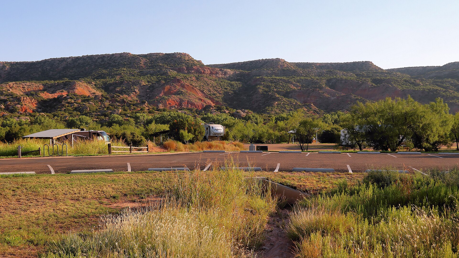
The Panhandle's immense red-rock canyon state park, often called the Grand Canyon of Texas, with more than 30 miles of hiking, biking and equestrian trails, dramatic rim-to-floor drives, CCC history and the iconic Lighthouse formation near Canyon and Amarillo.
Best season: Spring and fall for hiking; winter can be excellent on mild days, while summer requires early starts, heat awareness and frequent water breaks on exposed canyon trailsUpdated Aug 2026- Lighthouse Trail and the park's signature rock formation
- Canyon rim overlooks and scenic drive to the floor
- More than 30 miles of hiking, biking and equestrian trails
Terlingua · Brewster County
Big Bend National Park
Explore Big Bend's Chisos Mountains, Chihuahuan Desert and Rio Grande canyons using current NPS road closures, campground reservations and correct 2026 Chisos Basin construction status.
Best season: Fall through spring for hiking and lower-elevation exploring; summer heat can be extreme, so warm-season plans should favor early starts, higher elevations and conservative distancesUpdated Oct 2026- Chisos Basin access remains available despite canceled renovation closure
- Santa Elena Canyon: Terlingua Creek crossing varies with floods
- Ross Maxwell Scenic Drive: check closure and turnaround