
County Guide
Chambers County
Chambers County brings together Anahuac, Wallisville, the lower Trinity River, Trinity Bay wetlands, rice country, oil fields and one of the most important pre-Revolution flashpoints in Texas history.
- Guide type
- Texas county guide
- County seat
- Anahuac, Texas
- Source check
- Official source checked
- Last reviewed
- August 4, 2026
Verified county profile
What the data says about Chambers County
The 2020 Census counted 46,571 residents across about 597 square miles of land. Dividing those two Census figures gives roughly 78.0 residents per square mile.
Census geography also records about 274 square miles of water. Water represents approximately 31.5% of the county's mapped land-and-water area.
Anahuac is the verified county seat.
Texas Defined does not add an unsourced list of local communities. Additional places appear here only when the structured place directory contains a verified county relationship.
Understand the bigger picture
These Texas Explained guides add statewide context to the geography, settlement and infrastructure behind Chambers County.
Explore Texas Explained →Wildlife & public lands
National wildlife refuges connected to Chambers County
These TexasDefined refuge records are tied to Chambers County through verified federal location data and point to the U.S. Fish and Wildlife Service for current visitor conditions.
Statewide context
Where Chambers County sits in the county data
These ranks use the same Texas State Library and U.S. Census county dataset as the statewide comparison. A rank is shown only when that metric is available for the county and the comparison set; missing source values are excluded rather than estimated.
- 2020 population
- #73
- of 254 counties with source data
- land area
- #229
- of 254 counties with source data
- population density
- #56
- of 254 counties with source data
- water share
- #5
- of 254 counties with source data
Property tax rates
Taxing units in Chambers County
Texas property taxes are imposed by separate local taxing units. The table below lists finalized statewide records associated with Chambers County. A district appearing here does not mean every property in the county pays that district; use the exact parcel record to determine jurisdiction.
Checking finalized local tax rates…
At a glance
The county in numbers
- County seat
- Anahuac, Texas
- 2020 population
- 46,571
- Land area
- 597 sq. mi.
- Water area
- 274 sq. mi.
- Population density
- 78.0 / sq. mi.
- Water share
- 31.5%
County questions
Quick answers about Chambers County
What is the county seat of Chambers County?
Anahuac, Texas is the county seat of Chambers County.
How many people live in Chambers County?
The 2020 U.S. Census counted 46,571 residents in Chambers County.
How densely populated is Chambers County?
Using the 2020 Census population and Census land-area figure, Chambers County has about 78.0 residents per square mile. This is a derived density figure, not a separate Census estimate.
What cities and communities are in Chambers County?
Chambers County includes communities such as Anahuac. City limits, mailing addresses and county boundaries do not always match, so verify an exact address when county jurisdiction matters.
Where do I look up property taxes in Chambers County?
TexasDefined has not yet published a county-specific property-tax guide for Chambers County because its local source verification is still incomplete. Use the statewide county property-tax directory and the official local office links on this page while verification is pending.
How do I research industries and employers around Chambers County?
Start with the sector guides most closely tied to Chambers County's documented economy, then use Made in Texas and local sources to verify individual employers and facilities. These links describe county-to-sector context; they do not claim that every company in a statewide industry operates in Chambers County.
How do I find official Chambers County government information?
Start with the official Chambers County website for county departments, services, courts and records. For property values, exemptions and protests use the appraisal district; for tax bills and payments use the office designated by the taxing unit. TexasDefined links to the statewide property-tax county directory until this county-specific tax guide passes source verification.
Property taxes
County property-tax resources
Property-tax questions in Chambers County involve several separate authorities. Until the county-specific tax guide passes source verification, use the statewide county property-tax directory plus the official appraisal and tax-office resources shown here.
Property & county services
Official local resources
Property appraisal
The Comptroller directory entry is undated or more than two years old. This guide does not display potentially outdated individual contact details. Follow the official county directory link to verify the current office.
Comptroller office listing updated 2018-05-09; confirm contact details with the district before visiting.
Tax office
Tax assessor-collector: Laurie Payton
Phone: 409-267-2763
405 S. Main St. Anahuac, Texas 77514-9800
Comptroller office listing updated 2025-03-13; confirm vehicle and tax service details with the office before visiting.
Waterways
Rivers connected to Chambers County
Explore these rivers in their regional context. A county connection alone does not establish public river access, camping, parking or a safe paddling launch.
County feature
The story of Chambers County
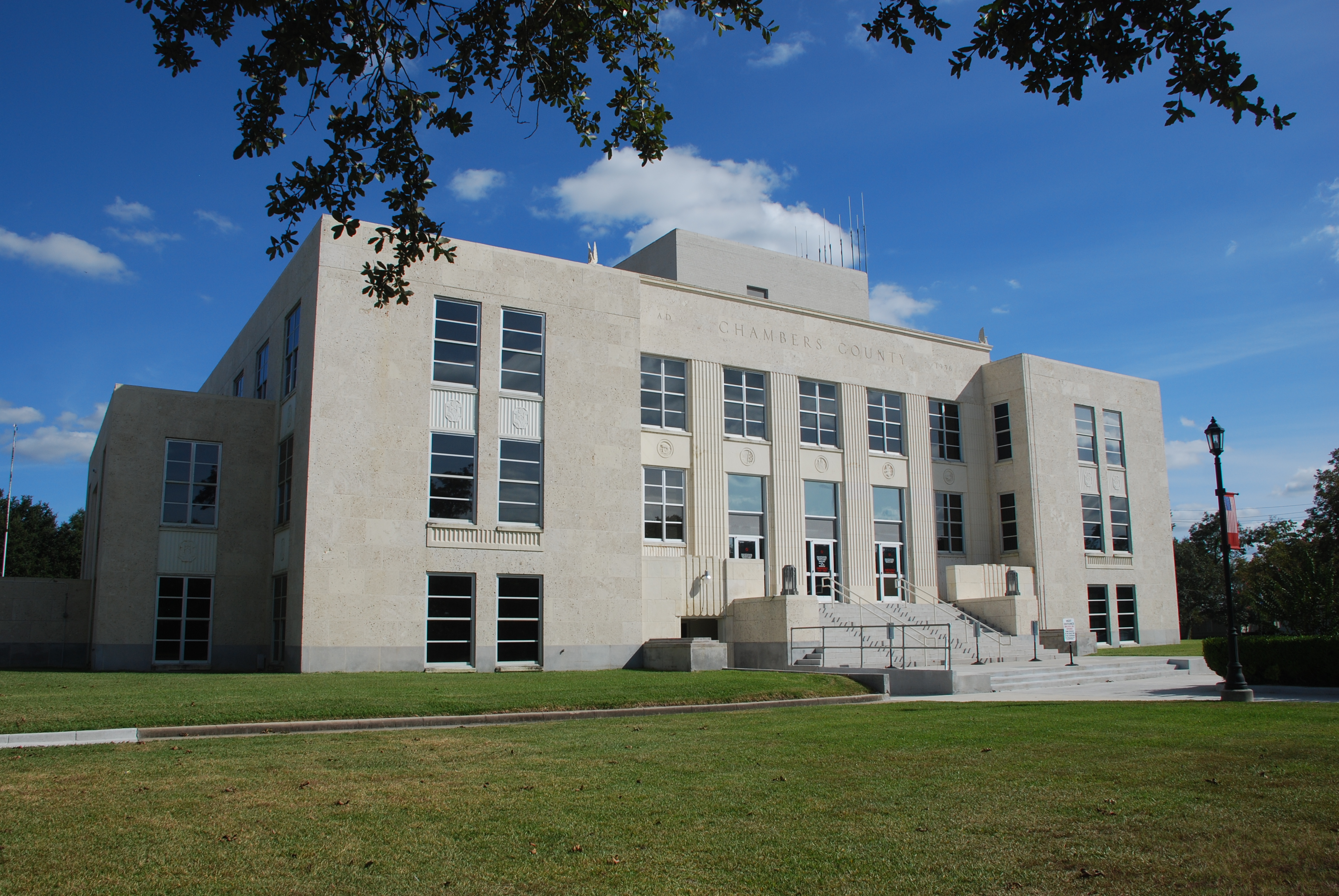
Chambers County: Anahuac, Trinity Bay and the Upper Texas Coast
Chambers County brings together Anahuac, Wallisville, the lower Trinity River, Trinity Bay wetlands, rice country, oil fields and one of the most important pre-Revolution flashpoints in Texas history.
Published August 21, 2026 · 15 min read
Chambers County sits where several versions of Texas meet. The lower Trinity River reaches the coast here, Trinity Bay opens toward Galveston Bay, coastal prairie gives way to marsh and open water, and Interstate 10 carries one of the busiest east-west corridors in the state across a county that still contains broad stretches of ranchland, rice fields and wildlife habitat. Anahuac is the county seat, while Wallisville, Winnie, Stowell, Mont Belvieu, Cove, Beach City, Old River-Winfree and smaller communities each reflect a different part of the county's history and economy.
For travelers, Chambers County can look deceptively flat and quiet from the highway. Its deeper story is anything but simple. Indigenous communities lived along these waters long before European settlement. Spanish and French rivalry reached the lower Trinity in the eighteenth century. Mexican authorities later built Fort Anahuac here, and disputes around that post became a direct prelude to the Texas Revolution. Ranching, rice, timber, oil, natural gas, refining, shipping and wetland conservation all followed, creating a county whose identity is tied as much to water and transportation as to any single town.
The lower Trinity and Trinity Bay shape the county
Water is the organizing force of Chambers County. The Trinity River descends through East Texas and enters the coastal plain near the county's western side before spreading toward Trinity Bay. Bayous, marshes, tidal flats and low prairie occupy large areas, especially toward the south. Trinity Bay itself forms much of the county's coastal edge and connects local waterways to the larger Galveston Bay system and the Gulf of Mexico.
That geography has always affected settlement. Waterways provided transportation when roads were poor, but storms and flooding made permanent development difficult in low-lying places. The same marshes that challenged farmers now support some of the most important bird and wildlife habitat on the upper Texas coast. To understand Chambers County, it helps to think in terms of river, bay and prairie rather than just highways and municipal boundaries.
Anahuac became one of the first flashpoints of the Texas Revolution
The site of modern Anahuac was strategically important because it overlooked access to the lower Trinity River. Mexican authorities established Fort Anahuac in 1830 under Colonel Juan Davis Bradburn as part of an effort to enforce immigration and customs laws. Tensions between Bradburn and Anglo-Texan settlers escalated over arrests, legal authority and resistance to the Law of April 6, 1830.
The confrontations known as the Anahuac Disturbances in 1832 and again in 1835 helped sharpen political resistance to Mexican rule. The 1832 episode led to the Turtle Bayou Resolutions, in which settlers framed their resistance as support for the federalist Constitution of 1824. Those events did not by themselves cause the Texas Revolution, but they made Anahuac one of the places where armed conflict and political arguments appeared before the broader war for independence.
Fort Anahuac still anchors the story
Fort Anahuac Park occupies the historic area associated with the Mexican garrison. Erosion and later development removed much of the original fort, and surviving archaeological evidence is limited, but the site remains one of the most important interpretive locations in Chambers County. Standing near the Trinity River makes the strategic logic of the fort immediately understandable: control of the waterway meant control of movement into the interior.
The park also connects the county's revolutionary-era history to modern Anahuac. What was once an isolated military outpost is now part of the county seat, close to public facilities, residential streets and the waterfront. That contrast is characteristic of Chambers County, where nationally important historical events often sit inside landscapes that still feel local and understated.
The county itself was created in 1858
Chambers County was formed in 1858 from parts of Liberty and Jefferson counties and named for Thomas Jefferson Chambers, a lawyer, landowner and political figure whose career stretched across Mexican Texas, the Republic and early statehood. Wallisville became the first county seat. The choice reflected the importance of the lower Trinity and water transportation at a time when interior roads were unreliable.
The new county's early economy depended heavily on livestock. Cattle were especially important, and the coastal prairie offered broad grazing country. Rice, cotton, timber, brickmaking and boatbuilding also appeared in different areas. Because railroads arrived slowly and unevenly, Chambers County remained more dependent on boats and regional ports than many inland Texas counties well into the late nineteenth century.
Wallisville was the first center of county government
Wallisville developed near the Trinity River and became a commercial and administrative center in the nineteenth century. Lumber activity, ranching and river traffic supported the town, and the county courthouse stood there before the seat moved to Anahuac. The community's location made sense when water was the easiest way to move people, freight and livestock.
Today Wallisville is much smaller, but its historical importance is preserved through local heritage efforts and the broader story of the Trinity River. The area also illustrates how transportation can reorder settlement. A place that was once central because of river traffic became less dominant after roads, rail and later highways shifted movement elsewhere.
Anahuac won the county-seat fight in the early twentieth century
Anahuac reemerged as an important settlement in the early 1900s after years of limited development. Canal construction, rice farming and renewed commercial activity gave the town momentum. In 1907 voters approved moving the county seat from Wallisville to Anahuac, and court challenges were ultimately unsuccessful. County records were transferred in 1908.
The current Chambers County Courthouse in Anahuac is one of the county's most recognizable civic landmarks. It represents the shift from a river-oriented nineteenth-century county to a twentieth-century county seat tied more closely to roads, agriculture, energy and regional government. The courthouse also provides a strong starting point for exploring Fort Anahuac, Lake Anahuac and the surrounding bay landscape.
Rice transformed the coastal prairie
Rice became one of Chambers County's signature crops in the early twentieth century. The flat coastal plain, warm climate and access to water made large-scale rice cultivation possible when canals and irrigation systems expanded. Winnie and Stowell became especially associated with rice farming, and the crop shaped local labor, land use, drainage and agricultural infrastructure.
The Texas Rice Festival, held in the Winnie-Stowell area, reflects that agricultural identity. Even as the county economy diversified, rice remained an important cultural marker because it connected families, businesses and communities across generations. The fields also became part of the county's wildlife story, providing seasonal habitat for waterfowl alongside natural wetlands.
Oil and gas added a second industrial layer
Petroleum development arrived in several parts of Chambers County during the twentieth century. Barbers Hill became one of the county's most important oil-producing areas, and additional fields were developed near Anahuac, Turtle Bay, Hankamer and other locations. Oil and natural gas reshaped property values, infrastructure and employment while connecting the county more directly to the rapidly expanding Gulf Coast refining and petrochemical economy.
Mont Belvieu became especially significant because of its location atop a salt dome and its relationship to underground storage, pipelines and energy processing. What had once been an agricultural and ranching landscape developed into a major node in the Gulf Coast hydrocarbon network. The contrast between Mont Belvieu's industrial infrastructure and the county's marshes, rice fields and cattle country is one of the clearest examples of Chambers County's mixed identity.
Interstate 10 changed the county's relationship to Houston and Beaumont
Modern Chambers County is crossed by Interstate 10, which links Houston with Beaumont, Orange and Louisiana. Communities near the corridor have grown in different ways as regional commuting, logistics, industry and residential development expanded. Mont Belvieu and the western side of the county increasingly interact with the Houston metropolitan economy, while Winnie and the eastern side maintain strong ties toward Beaumont and Southeast Texas.
The interstate also makes the county easy to pass through without noticing how different its landscapes are. A short drive south from the freeway can lead from warehouses and energy infrastructure into rice fields, marshes, bayous and national wildlife refuge land. That abrupt transition is one of the defining geographic experiences of the county.
Anahuac National Wildlife Refuge protects coastal marsh on a major migration route
Anahuac National Wildlife Refuge lies south of Anahuac near the upper Texas coast. The refuge protects marsh, prairie, shallow water and associated habitats used by migratory birds, alligators and other wildlife. Its position near Trinity Bay and the Gulf places it along one of North America's most important bird migration corridors.
Birding is especially important here during spring and fall migration, when weather systems can concentrate large numbers of birds along the coast. Waterfowl are prominent in winter, while wading birds, shorebirds and raptors can be seen through much of the year. The refuge also provides a direct visual lesson in why Chambers County's low, wet geography matters far beyond county lines.
The county is known as the Alligator Capital of Texas
Anahuac has long embraced its relationship with alligators and coastal wetlands, and the annual Texas Gatorfest grew from that local identity. The event combines entertainment with a distinctly Southeast Texas sense of place. It works because alligators are not an abstract symbol here; they are part of the actual marsh and bayou ecosystem surrounding the county seat.
Visitors should still treat wildlife as wild. Alligators can occur in ponds, canals, marshes and other waterways throughout the region. Feeding or approaching them is unsafe and can alter their behavior. The best encounters are distant ones from designated roads, trails, observation areas or vehicles.
Smith Point reaches into Trinity Bay
Smith Point sits on a peninsula extending into the bay system and offers one of the county's strongest examples of how land and water interlock. The area is associated with fishing, bird migration and broad coastal views. Seasonal bird movements can be especially dramatic because the geography funnels migrants along the coast.
The drive toward Smith Point also reveals the county's vulnerability to tropical weather. Homes, roads and working land occupy a low coastal environment where storm surge, wind and flooding are recurring risks. The beauty of the open bay landscape and the exposure to hurricanes are two sides of the same geography.
Hurricanes are part of the county's historical record
Chambers County has repeatedly been affected by hurricanes and tropical storms. Historic storms damaged communities, altered shorelines and disrupted agriculture, while more recent events have brought storm surge, flooding and long recovery periods. Coastal and riverine hazards remain part of everyday planning for residents.
This is not merely a weather footnote. Flood control, evacuation routes, building practices, wetland conservation and road design all reflect the county's environmental conditions. Anyone exploring the area during hurricane season should treat official forecasts, road closures and local emergency information as essential.
Cattle, farming and wetlands still share the landscape
Despite industrial growth, large parts of Chambers County remain rural. Cattle operations, hay fields, rice acreage and other agricultural uses continue across the coastal prairie. In some places, working farmland lies directly beside wetlands that support waterfowl and other wildlife, creating a landscape where agriculture and habitat overlap.
That overlap has historical roots. Ranching preceded the county's oil economy by generations, and rice cultivation became established long before modern suburban growth. Chambers County therefore offers a useful view of how Gulf Coast Texas evolved without completely losing its older agricultural patterns.
A practical way to explore Chambers County
Start in Anahuac at the courthouse and Fort Anahuac Park, then continue toward Lake Anahuac and the lower Trinity landscape. From there, a southbound route toward Anahuac National Wildlife Refuge introduces the marshes and coastal prairie that define much of the county. Birding and wildlife conditions change with season, weather and water levels, so current refuge information is worth checking before a visit.
A second route can follow Interstate 10 through Wallisville, Winnie and toward the eastern county line, focusing on the county's transportation and agricultural history. Traveling west toward Mont Belvieu reveals the energy and petrochemical side of Chambers County. Together, these routes show why the county cannot be reduced to one identity: it is historical, agricultural, industrial and ecological at the same time.
Chambers County today
Chambers County is one of the best places on the upper Texas coast to see how geography directs history. The lower Trinity drew Indigenous communities, explorers, soldiers and settlers. Coastal prairie supported cattle and rice. Salt domes and petroleum connected the county to the Gulf Coast energy economy. Marshes and bays created both storm risk and nationally significant wildlife habitat.
Anahuac remains the civic center and historical anchor, but the county's story is distributed across Wallisville, Winnie-Stowell, Mont Belvieu, Smith Point, the bay shore and the wildlife refuge. What ties those places together is movement: river traffic, cattle drives, canals, pipelines, highways, bird migration and storm systems have all crossed this low coastal landscape and left visible marks.
Keep exploring the upper Texas coast
From Chambers County, head north into Liberty County to follow the Trinity River and the older Atascosito corridor. Travel east into Jefferson County for Beaumont, Spindletop and the Sabine-Neches ship channel, or continue farther east to Orange County and the Sabine River. Each neighboring county adds another piece to the story of how waterways, energy, settlement and coastal geography shaped Southeast Texas.
Sources & verification
Research and official records
Research references support the editorial history and places described above. The official directories below help verify current county seats, census geography, property tax offices and vehicle services. Office personnel, contact details and links can change; check the agency website before traveling.
A claim-by-claim county-specific source list has not yet been published for this guide. The official starting points below are not a substitute for documented historical research.
Further county history research
Use the published county history as independent background reading, not as proof that every claim in this guide has been checked against that reference.
Town and local attraction guides
Explore Chambers County in more depth
Explore these independent town guides for history, primary-source links, area attractions, trip timing, access considerations and nearby places. Town boundaries and regional side trips are distinguished from the county itself.
- Anahuac
Locally researched history, travel logistics, attractions, itineraries and primary visitor sources.
Local places to visit
More to explore in Chambers County
These additional local places complement the park, museum, beach and other destination guides on this county page. They are not ranked. For events, swimming, tours or restricted properties, always check current visitor information before traveling.
- Parks & recreation
Jocelyn Nungaray National Wildlife Refuge
Coastal-marsh refuge near Anahuac with Shoveler Pond wildlife drive, butterfly garden, boardwalks and public birdwatching areas; formerly Anahuac NWR.
Texas tournaments
Tournaments & competitions near Chambers County
Browse TexasDefined’s statewide tournament directory across golf, rodeo, team sports, fishing, BBQ, chess, esports, academic competitions and more. County relationships are published only when a location can be assigned confidently; current dates, venues and entry details require organizer verification.
Texas high school football
High school football in Chambers County
See current UIL football programs whose TEA school-directory records are in Chambers County. Use the statewide finder to compare a specific high school or ISD before choosing where to live.
Open the statewide football finder →Loading current UIL football programs…
What this tells you: current 2026–28 UIL classification, football division, district and six-man/11-man format. School, ISD, city and county context is attached only when Texas Education Agency AskTED produces an unambiguous campus match; uncertain matches are deliberately omitted.
All-time state-final history: title and appearance totals use UIL’s Football All-Time Appearances table, supplemented with newer completed state-final rows from the official State Archives when that all-time table trails the latest archive. Totals appear only on an exact normalized UIL school-name match.
Recent state-final detail: the game-level list covers the eight completed UIL championship seasons from 2018–19 through 2025–26. No history badge does not mean a weak program; it means the source did not produce an exact normalized school-name match.
This is not a “best school” rating. Football placement and recent championship history are only parts of researching a program. Attendance zones, transfers, eligibility and campus assignments can change, so confirm an exact address and student eligibility with the school district and UIL before making a move.
Researched local football programs
Football history connected to Chambers County
- Anahuac Panthers football authority guide →
Panthers football history and 2026 classification
- East Chambers Buccaneers football authority guide →
East Chambers campus in Chambers County; 3A Division I
Independent editorial guides. Game sites and district boundaries may span county lines; each listed school is linked by its campus county.