Skip to content
Sea Rim State Park in Texas

Gulf Coast · Beaches & Coast

Sea Rim State Park

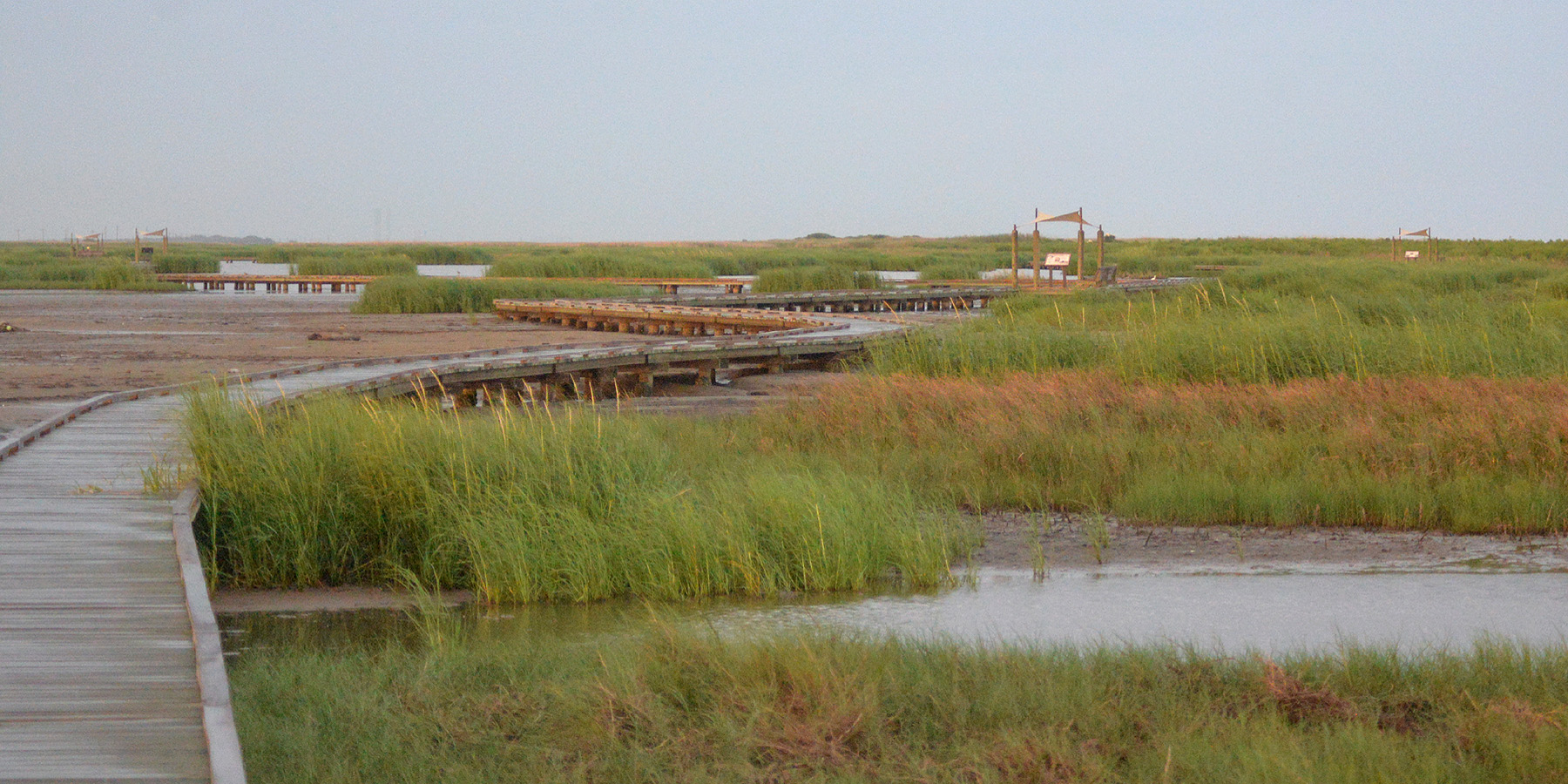
A remote Gulf Coast park where marsh meets beach near Sabine Pass, combining more than five miles of shoreline with paddling trails, birding, fishing and primitive coastal camping.

Photography: William L. Farr · CC BY 4.0 · Wikimedia Commons

Quick trip facts

Sea Rim State Park at a glance

Where is Sea Rim State Park?
Sea Rim State Park is at 19335 S. Gulfway Drive, Sabine Pass, TX 77655, in Jefferson County.
When is the best time to visit Sea Rim State Park?
Fall through spring for birding and milder beach weather
Do I need to plan ahead for Sea Rim State Park?
Coastal weather, tides and storms can affect beach and marsh access. Check park alerts and marine conditions before the drive.
Who manages Sea Rim State Park?
Texas Parks and Wildlife Department

Practical visitor details

Before you go

Day-use entry fee
Adults 13 and older: $4 daily; children 12 and younger: free.
Checked · Official details ↗
Daily park hours
The park is open daily from 6 a.m. to 10 p.m.
Checked · Official details ↗
Park office and late arrivals
Office hours differ by day: Monday 8 a.m.–2 p.m.; Tuesday–Thursday 8 a.m.–3:30 p.m.; Friday–Sunday 8:30 a.m.–4:30 p.m. Late-arriving campers must contact the park during office hours.
Checked · Official details ↗

The experience

What to know about Sea Rim State Park

Sea Rim sits at one of the most interesting ecological edges in Texas: salt marsh on one side and open Gulf beach on the other. The park feels remote, flat and exposed, with weather and water shaping almost every part of the experience.

Visitors can move between beach walking, fishing and camping on the shoreline and paddling routes through the marsh. Migration seasons can bring exceptional birdlife, while the open horizon makes even a simple sunset feel like a destination event.

This is a place to plan around conditions rather than a fixed schedule. Tropical systems, high tides, wind and heavy rain can change access quickly, so check current park and coastal alerts before leaving.

Location-specific coastal research

Access, swimming and local rules at Sea Rim State Park

A state park where nearly two miles of Gulf beach meet thousands of acres of marsh, combining swimming and surf fishing with paddling, birding and primitive coastal camping.

What kind of beach is this?
This is a managed park with its own rules, possible admission or parking arrangements, and specified public-use areas. The park designation alone does not mean all shorelines within it are safe or open for swimming.
Who can get in, and what might it cost?
The managing park or facility may charge entry, parking or day-use fees. Verify current prices and reservations directly; old fee tables can be misleading.
Important local planning detail
Check TPWD alerts and day-use capacity before the drive; beach and marsh conditions can change after storms and high water.
Location and managing source
Sabine Pass, Jefferson County · Upper Gulf Coast. Source: Texas Parks & Wildlife; last research date 2026-09-06. Coordinates elsewhere on this guide identify a representative arrival area, not precise shoreline boundaries.

Confirm before you go

This is research-backed visitor information, not a live access, parking, beach flag or bacteria status. A destination being listed does not establish that swimming is permitted or safe today. Check the relevant managing source and local signs, especially after storms, flooding or beach work.

Texas Parks & Wildlife — source for this location →

The details

Planning your visit

Area
Sabine Pass, Texas
Best season
Fall through spring for birding and milder beach weather
Address
19335 S. Gulfway Drive, Sabine Pass, TX 77655
Entry & reservations
Coastal weather, tides and storms can affect beach and marsh access. Check park alerts and marine conditions before the drive.
Getting there
Approach from Port Arthur on State Highway 87; TPWD notes Highway 87 is closed between Sea Rim and High Island. Do not route through that closed stretch.

Texas State Parks · trip planning

Park entrances, facilities and visitor maps

Amenities can differ by park unit, campsite and season. The details below are park-specific where checked against TPWD. For changing hours, reservations, trail conditions and facility availability, use the park's official visitor resources.

Restrooms and showers
TPWD confirms the park restrooms are wheelchair accessible. The Piping Plover electric campsites themselves are not designated ADA-accessible; confirm bathroom access and distance for West Beach primitive camping, particularly during closures.
Parking, entrance and access
15 developed electric sites occupy the Piping Plover loop near the dune boardwalk. Primitive beach camping is west of the developed section and may close due to tides or storm conditions.
Camping, RV hookups and drinking water
TPWD lists 15 electric sites with water and 75 primitive beach sites. Primitive sites are first-come, not advance reservable, and can be closed by high tides.
Trails, parking and visitor maps
TPWD provides park and trails maps, plus an interactive trails map.
Access restrictions and current visitor rules
State Highway 87 is closed between Sea Rim and High Island; approach from Port Arthur/Sabine Pass. Call for camping access and coastal conditions before travel.

Park-specific visitor facts checked 2026-10-12 against the TPWD source. Additional official TPWD reference: TPWD source page.

Explore Texas state parks

Connected museum guides

Museums to explore nearby

Museum guides relevant to Sabine Pass and its surrounding history. Tickets, hours and travel arrangements are separate at each institution.

Plan the route

Explore related places

Editorially paired stops near Sea Rim State Park appear first, followed by nearby destinations. Distances are approximate straight-line miles.

  • Sabine Pass · Jefferson County · Gulf Coast

    McFaddin National Wildlife Refuge

    McFaddin National Wildlife Refuge near Sabine Pass protects nearly 59,000 acres of freshwater, intermediate and brackish marsh, including one of the largest remaining freshwater marsh systems on the Texas Coast.

    Best season: Fall through spring for waterfowl and comfortable coastal recreation; summer is hot, humid and insect-heavy.Updated Sep 2026
    • Freshwater and brackish marsh
    • Fishing and crabbing
    • Waterfowl habitat
    Explore this place

    Approx. 2 miles away

  • Sabine Pass · Jefferson County · Gulf Coast

    McFaddin Beach

    A remote Gulf shoreline associated with McFaddin National Wildlife Refuge, better suited to beachcombing, fishing, wildlife watching and self-reliant coastal trips than resort-style amenities.

    Best season: March through May and September through November for milder beach weather; summer is busiest and hottestUpdated Sep 2026
    • Open-Gulf beach
    • Upper Gulf Coast setting
    • Sabine Pass access
    Explore this place

    Approx. 3 miles away

  • Sabine Pass · Jefferson County · Gulf Coast

    Texas Point National Wildlife Refuge

    Texas Point National Wildlife Refuge near Sabine Pass protects marsh, chenier and coastal habitat at the far eastern end of the Texas Coast, supporting migratory birds, waterfowl and wildlife-dependent recreation near the Louisiana border.

    Best season: Fall through spring for migration and waterfowl; spring can be notable for Gulf-crossing songbirds using coastal habitat.Updated Sep 2026
    • Upper Coast marsh habitat
    • Migratory bird corridor
    • Waterfowl hunting
    Explore this place

    Approx. 6 miles away

  • Sabine Pass · Jefferson County · Gulf Coast

    Sabine Pass Battleground State Historic Site

    The site marks the 1863 Civil War battle in which a small Confederate force stopped a much larger Union operation near the mouth of the Sabine River. Its Gulf Coast setting helps explain the strategic importance of ports, waterways and access to Texas during the Civil War.

    Best season: Year-round; spring and fall are usually the most comfortable for outdoor portions of a visit.Updated Aug 2026
    • Civil War
    • Gulf Coast
    • military history
    Explore this place

    Approx. 9 miles away

  • Port Arthur · Jefferson County · Gulf Coast

    J.D. Murphree Wildlife Management Area

    J.D. Murphree WMA protects roughly 25,852 acres of fresh, intermediate and brackish coastal marsh near Port Arthur, forming a major upper-coast wetland complex beside Sabine Lake.

    Best season: Late spring and summer for marsh birds and visible wetland wildlife; fall and winter access is more constrained by public waterfowl hunts.Updated Sep 2026
    • 25,000-plus acres of coastal marsh
    • Sabine Lake and Chenier Plain wetlands
    • Viewing platform and boat-access wildlife viewing
    Explore this place

    Approx. 13 miles away

  • Port Arthur · Jefferson County · Gulf Coast

    Museum of the Gulf Coast

    The Museum of the Gulf Coast in Port Arthur interprets the natural, cultural and industrial history of Southeast Texas and Southwest Louisiana, with regional collections and halls of fame for music, sports and notable Gulf Coast figures.

    Updated Oct 2026
    • Gulf Coast history and maritime collections
    • Music Hall of Fame including Port Arthur native Janis Joplin
    • Sports and Notable People halls of fame
    Explore this place

    Approx. 15 miles away

Read next

More from Beaches & Coast

Beaches & Coast

How to Pick the Right Texas Beach

The Texas coast is not one beach repeated for 367 miles. Barrier islands, fishing towns and bays each reward a different kind of weekend.

August 7, 2026 · About 3 minutes