
County Guide
Bexar County
The San Antonio River, Spanish missions, military institutions, old farming communities and fast-growing suburbs make Bexar County one of the clearest places to read the long arc of Texas history in a living modern landscape.
- Guide type
- Texas county guide
- County seat
- San Antonio, Texas
- Source check
- Official source checked
- Last reviewed
- August 4, 2026
Verified county profile
What the data says about Bexar County
The 2020 Census counted 2,009,324 residents across about 1,240 square miles of land. Dividing those two Census figures gives roughly 1,620 residents per square mile.
Census geography also records about 16 square miles of water. Water represents approximately 1.3% of the county's mapped land-and-water area.
San Antonio is the verified county seat.
Texas Defined does not add an unsourced list of local communities. Additional places appear here only when the structured place directory contains a verified county relationship.
Understand the bigger picture
These Texas Explained guides add statewide context to the geography, settlement and infrastructure behind Bexar County.
Explore Texas Explained →Historic places in this county
History you can visit in Bexar County
Texas Defined currently connects 27 historic destinations to this county guide.
Statewide context
Where Bexar County sits in the county data
These ranks use the same Texas State Library and U.S. Census county dataset as the statewide comparison. A rank is shown only when that metric is available for the county and the comparison set; missing source values are excluded rather than estimated.
- 2020 population
- #4
- of 254 counties with source data
- land area
- #37
- of 254 counties with source data
- population density
- #4
- of 254 counties with source data
- water share
- #98
- of 254 counties with source data
Property tax rates
Taxing units in Bexar County
Texas property taxes are imposed by separate local taxing units. The table below lists finalized statewide records associated with Bexar County. A district appearing here does not mean every property in the county pays that district; use the exact parcel record to determine jurisdiction.
Checking finalized local tax rates…
Made, built & born here
Texas products and companies tied to this county
Texas Defined separates products actually made or processed locally from companies that were founded, headquartered or operate major facilities here.
Headquartered here
Whataburger
San Antonio
The Texas-born burger chain is headquartered in San Antonio.
Headquartered here
H-E-B
San Antonio
The grocery company is headquartered in San Antonio and is one of the state's largest homegrown retail institutions.
Founded here
Taco Cabana
San Antonio
The fast-casual Tex-Mex chain began in San Antonio.
Made or processed here
Rebecca Creek Distillery
San Antonio
San Antonio-area distillery producing Texas spirits.
Verified source: Rebecca Creek Distillery ↗Made or processed here
Ranger Creek Brewing & Distilling
San Antonio
Beer and spirits producer based in San Antonio.
Verified source: Ranger Creek Brewing & Distilling ↗Made or processed here
All Seasons Feeders
San Antonio
All Seasons Feeders labels its feeders and blinds as built or made in Texas and operates from San Antonio.
Verified source: All Seasons Feeders ↗Made or processed here
Texas Hunter Products
San Antonio
Texas Hunter Products manufactures feeders, blinds and outdoor equipment and operates from San Antonio.
Verified source: Texas Hunter Products ↗Made or processed here
Toyota Motor Manufacturing Texas
San Antonio
San Antonio vehicle plant is a major Texas manufacturing site.
Verified source: Toyota USA Newsroom ↗Manufacturing footprints change. A Texas headquarters or founding city is not presented as proof that every current product is made in Texas.
Browse the statewide Made in Texas guide →Lakes and recreation
Fishing lakes in Bexar County
These source-backed TexasDefined guides cover reservoirs and public lakes associated with this county. Review access and the managing agency's current notices before travel; a county link does not imply every part of a lake or every ramp lies within the county.
Explore all completed Texas fishing lake guides →Painted Churches
Painted Churches in Bexar County
Our statewide Painted Churches collection includes 1 church in Bexar County. This guide connects its local history, architecture, decorative arts, preservation, and immigrant heritage to the broader story of Texas Painted Churches.
At a glance
The county in numbers
- County seat
- San Antonio, Texas
- 2020 population
- 2,009,324
- Land area
- 1,240 sq. mi.
- Water area
- 16 sq. mi.
- Population density
- 1,620 / sq. mi.
- Water share
- 1.3%
County questions
Quick answers about Bexar County
What is the county seat of Bexar County?
San Antonio, Texas is the county seat of Bexar County.
How many people live in Bexar County?
The 2020 U.S. Census counted 2,009,324 residents in Bexar County.
How densely populated is Bexar County?
Using the 2020 Census population and Census land-area figure, Bexar County has about 1,620 residents per square mile. This is a derived density figure, not a separate Census estimate.
What cities and communities are in Bexar County?
Bexar County includes communities such as San Antonio. City limits, mailing addresses and county boundaries do not always match, so verify an exact address when county jurisdiction matters.
Where do I look up property taxes in Bexar County?
Start with the verified Bexar County property-tax guide for the local workflow. The appraisal district handles property records, values, exemptions and protests; the designated collecting office handles bills and payments for each taxing unit.
How do I research industries and employers around Bexar County?
Start with the sector guides most closely tied to Bexar County's documented economy, then use Made in Texas and local sources to verify individual employers and facilities. These links describe county-to-sector context; they do not claim that every company in a statewide industry operates in Bexar County.
How do I find official Bexar County government information?
Start with the official Bexar County website for county departments, services, courts and records. For property values, exemptions and protests use the appraisal district; for tax bills and payments use the office designated by the taxing unit. TexasDefined's verified county property-tax guide explains which local office handles each step.
Property taxes
County property-tax resources
Property-tax questions in Bexar County involve several separate authorities. Use the verified county property-tax guide for the full workflow, then move to the appraisal district for values and exemptions and the correct collecting unit for billing and payment.
Property & county services
Official local resources
Property appraisal
Chief appraiser: Rogelio Sandoval
Phone: 210-242-2432
411 N. Frio St. San Antonio, TX 78207-4416
Comptroller office listing updated 2026-08-20; confirm contact details with the district before visiting.
Tax office
Tax assessor-collector: Mr. Albert Uresti, MPA
Phone: 210-335-2251
233 N. Pecos La Trinidad San Antonio, Texas 78207-3175
Comptroller office listing updated 2025-03-03; confirm vehicle and tax service details with the office before visiting.
Waterways
Rivers connected to Bexar County
Explore these rivers in their regional context. A county connection alone does not establish public river access, camping, parking or a safe paddling launch.
County feature
The story of Bexar County
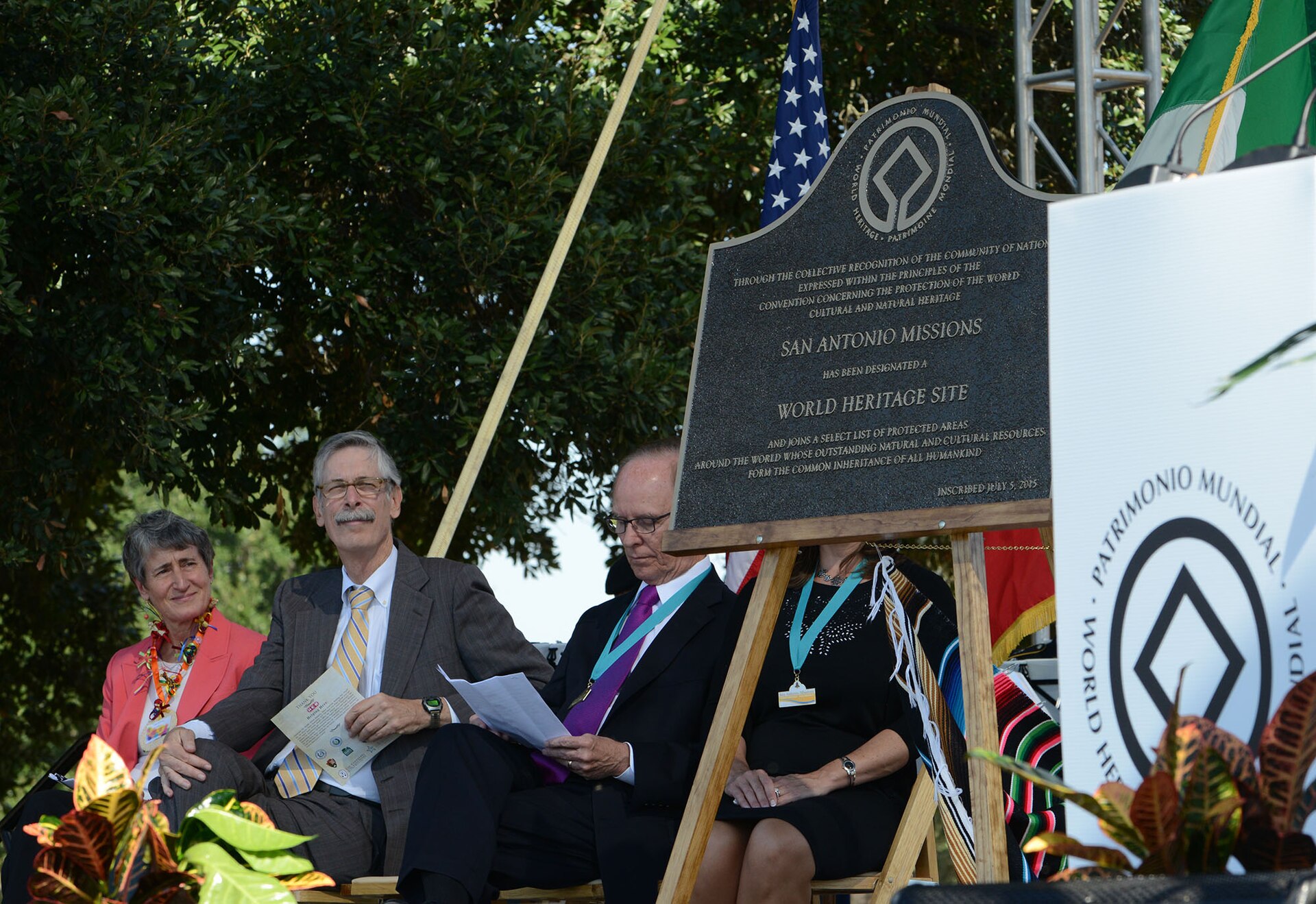
Bexar County: San Antonio, the Missions and a River-Shaped Texas Crossroads
The San Antonio River, Spanish missions, military institutions, old farming communities and fast-growing suburbs make Bexar County one of the clearest places to read the long arc of Texas history in a living modern landscape.
Published August 11, 2026 · 10 min read
Bexar County is often introduced through San Antonio, but the county makes more sense when the city is treated as the center of a much larger landscape rather than the whole story. The San Antonio River and its springs shaped Indigenous life long before Europeans arrived. Spanish missions, a presidio and a civilian settlement then turned the river corridor into one of the most important colonial centers in Texas. Military posts, railroads, ranches, farms, highways and suburban growth layered themselves onto that older geography. Today the county stretches from dense urban neighborhoods to limestone-edged northern hills and flatter agricultural country to the south and east. Its identity is not one era or one landmark; it is the accumulation of several Texas histories that remain visible at the same time.
The river came before the city
The basic geography of Bexar County begins with water. The San Antonio River rises from springs in the north-central part of the county and flows south through the modern city before continuing toward the Gulf Coast. Indigenous peoples knew this waterway long before Spanish settlement; the National Park Service notes the name Yanaguana in connection with Indigenous traditions of the river. Springs, creeks and river-bottom habitats offered water, plants, game and travel corridors in a region where dependable water could determine where people lived and moved.
That same water system explains why Spanish settlement concentrated here. The river could support people, livestock and irrigated agriculture, while its position between northern New Spain and East Texas made the area useful as a frontier outpost. Even modern Bexar County still follows that environmental logic. Parks, neighborhoods, roads, flood-control projects and development patterns repeatedly meet the same river valleys and drainage systems that shaped earlier settlement.
Mission communities transformed the San Antonio River corridor
Beginning in 1718, Spanish officials and Franciscan missionaries established a chain of mission communities along the San Antonio River. Mission Valero, later known as the Alamo, began the sequence. Mission San José followed in 1720, while Mission Concepción, Mission San Juan and Mission Espada were relocated to the San Antonio area in 1731. These were not simply churches placed on an empty frontier. They were colonial communities that combined religious conversion, farming, ranching, workshops, defense and political expansion.
The people who entered the missions included Indigenous families from many distinct South Texas groups that Spanish records often placed under the broad label Coahuiltecan. National Park Service interpretation emphasizes that the missions brought profound disruption as well as cultural exchange. Indigenous residents supplied most of the mission population and much of the labor, while Spanish institutions pushed new religion, language, farming methods and settlement patterns. Descendant communities remain connected to these places, and the mission churches continue to function as active parishes. That continuity is why the missions are more than preserved architecture: they are still part of living Bexar County communities.
Acequias turned water into an agricultural system
One of the most revealing features of mission-era Bexar County is easy to overlook because it lies low in the landscape. The missions depended on acequias, irrigation ditches that diverted river water into fields. Gravity carried water through channels engineered to serve cropland, workshops and communities. The National Park Service describes surviving acequias as part of an agricultural system that allowed crops such as corn, beans, squash and peppers to grow in the South Texas climate.
The acequias are important because they connect architecture to ecology. The missions could not have functioned as self-supporting communities without controlling water. Remnants and working portions of that system still help explain why the mission chain follows the river so closely. They also make Bexar County's colonial story physical: the same waterway that drew settlement still runs beside fields, neighborhoods, parks and restored river habitat today.
San Fernando created a civilian center beside the missions
The Spanish colonial settlement was never only a mission network. In 1731 Canary Island settlers established the villa of San Fernando de Béxar near the presidio and missions, creating a formal civilian government. The Bexar County government traces the county's name through San Antonio de Béxar and the earlier Presidio San Antonio de Béjar. Over time the spelling became Bexar, while the local pronunciation evolved into the familiar 'Bear.'
That civilian settlement helped give San Antonio a role different from many frontier posts. It became an administrative, commercial and cultural center as well as a military and religious one. Streets, plazas and property patterns grew around Spanish institutions, then adapted through Mexican rule, the Republic of Texas and statehood. Modern downtown San Antonio still occupies that inherited civic landscape, even though later construction has transformed nearly every block around it.
The Archdiocese of San Antonio's 1926 elevation and 2026 centennial
Religious institutions did not stop evolving after Spanish colonial government ended. The Roman Catholic Diocese of San Antonio was established in 1874, decades after the first mission and parish communities. On August 3, 1926, the Holy See elevated it to the rank of metropolitan archdiocese. That event—not the founding of the missions, San Fernando parish or the 1874 diocese—is what the archdiocese marked as its 100th anniversary in 2026. The organization's own history and centennial records identify the distinct dates, which are easy to confuse when describing a city whose Catholic history reaches back more than three centuries.
The archdiocese's official historical interpretation places the 1926 elevation alongside religious persecution in Mexico and the arrival of displaced clergy and faithful during the Cristero War. Its own centennial materials describe refuge and the formation of communities that shaped local education, parish life and religious practice. These are the archdiocese's institutional accounts, not a claim that every historic mission or Bexar County resident shares the same religious experience.
On November 7, 2026, the centennial Mass ultimately took place at Greehey Arena at St. Mary's University, where Archbishop Gustavo García-Siller presented the institution's new pastoral vision. Early organizer announcements named Wolff Stadium, but independent post-event reporting confirms a rain-related venue change. For readers researching the actual centennial ceremony, do not mistake the original venue on a pre-event promotion for the location where it happened. These dates describe a completed historical gathering, not a recurring annual event or a future ticketing opportunity.
The Alamo is only one chapter in the county's revolutionary landscape
Mission Valero became the Alamo and, through the 1836 battle, the most internationally recognized historic site in Bexar County. Its importance is real, but treating the county only through the Alamo compresses a much longer story into thirteen days. San Antonio de Béxar had already been a Spanish and Mexican political center for generations. Tejano families, soldiers, merchants, Indigenous residents and newcomers all shaped the community before the Texas Revolution began.
The revolution also changed Bexar County's political geography. When the Republic of Texas created Bexar County in December 1836, the county was enormous, reaching far beyond the boundaries familiar today. Bexar County's own historical account notes that 128 later counties were eventually carved from territory associated with the original county. The modern county is therefore a remnant of an earlier administrative map that treated San Antonio as the governing center for much of western Texas.
The missions became a World Heritage landscape
In 2015 UNESCO inscribed the San Antonio Missions as a World Heritage Site. The designation includes five mission complexes and associated cultural landscape features. Four missions—Concepción, San José, San Juan and Espada—form San Antonio Missions National Historical Park, while Mission Valero is the Alamo. UNESCO emphasizes the missions as evidence of interaction between Spanish and Indigenous cultures, visible not only in churches but also in residences, agricultural lands, ranching, workshops and water-distribution systems.
For Bexar County, the World Heritage designation matters because it recognizes a landscape rather than a single monument. The mission corridor stretches south from downtown along the river. Walking, driving or cycling between the sites reveals neighborhoods, parish life, river restoration and old agricultural ground between the stone compounds. The distance between missions helps restore the scale of the original system in a way that a single-site visit cannot.
The military became one of Bexar County's defining institutions
San Antonio's military role did not end with the Spanish presidio. The United States Army established a presence in the city in the nineteenth century, and Fort Sam Houston grew into one of the country's important military installations. In the twentieth century aviation and training expanded the military geography across Bexar County. Lackland developed from the World War II-era San Antonio Aviation Cadet Center, while Randolph Field became a major flying-training base. Camp Bullis occupied a large tract of rugged land in northwestern Bexar County for military training.
Those installations now operate within Joint Base San Antonio, which combines Fort Sam Houston, Lackland and Randolph with additional operating locations. The military presence is visible far beyond base gates. It shapes employment, medical institutions, contracting, transportation, neighborhoods and the steady movement of service members and families into and out of the county. In a place often marketed for tourism and heritage, defense remains one of the most consequential parts of the local economy and culture.
Growth pushed Bexar County far beyond the old city
San Antonio remains the county seat and dominant city, but contemporary Bexar County includes a ring of independent municipalities and suburban communities that complicate any simple city-versus-country picture. Alamo Heights, Terrell Hills, Olmos Park, Balcones Heights, Leon Valley, Castle Hills, Converse, Kirby, Live Oak, Universal City and other municipalities each developed their own civic identities within the larger metropolitan fabric. Unincorporated areas continue beyond them, particularly toward the county edges.
Northern Bexar County reaches into limestone Hill Country terrain, where development climbs ridges and follows creek valleys. To the south, the land opens toward the South Texas plains and the mission corridor. Eastern Bexar County contains long-established communities intertwined with military and industrial growth, while western areas have absorbed some of the region's fastest suburban expansion. The result is a county where an eighteenth-century mission acequia and a new master-planned subdivision can belong to the same local geography.
Transportation repeatedly remade the county
Bexar County's position as a crossroads long predates the interstate highway system. Indigenous travel routes, Spanish roads and the Camino Real connected San Antonio to Mexico, East Texas and other frontier settlements. Nineteenth-century wagon and stage routes reinforced the city's regional role. Railroads then tied San Antonio more closely to national markets, supporting livestock, freight, military logistics and urban growth.
Modern highways expanded that pattern on a metropolitan scale. Interstate 10, Interstate 35, Interstate 37, Loop 410 and Loop 1604 organize much of today's development, with commercial corridors and subdivisions spreading outward from interchanges. These roads made distant parts of the county easier to reach, but they also created a geography of long commutes, frontage-road commerce and rapid land conversion. To understand modern Bexar County, it helps to see highways as another layer on a much older transportation landscape.
The economy is broader than tourism
Visitors naturally associate Bexar County with the Alamo, River Walk, conventions, restaurants and major attractions, and hospitality remains highly visible. But the county's economy is much broader. Federal and military employment, health care, bioscience, higher education, finance, logistics, construction, manufacturing, retail and professional services all operate at metropolitan scale. Census business data show a large and diverse employer base, while Joint Base San Antonio anchors a defense network that reaches into medicine, cybersecurity, aviation and contracting.
This diversity helps explain why Bexar County can feel like several economies sharing one map. Downtown and the river corridor depend heavily on visitors and institutions. Military districts support specialized services and housing markets. Medical and university centers create their own employment clusters. Industrial and logistics facilities follow highway and rail corridors. New residential development then pushes demand for schools, roads, utilities, retail and public services farther toward the county edges.
Food and culture carry older mixtures forward
Bexar County's cultural identity grew from centuries of contact among Indigenous, Spanish, Mexican, Tejano, German, Anglo, Black and other communities. That history is visible in language, architecture, religious traditions, music and food. San Antonio's culinary reputation is not just a collection of famous dishes; it reflects borderlands exchange, migration and neighborhood continuity. Markets, bakeries, barbecue restaurants, taquerias and family kitchens preserve overlapping traditions rather than a single definition of South Texas food.
The same is true of festivals and public spaces. Historic plazas, mission parishes, neighborhood celebrations, rodeo traditions, military ceremonies and major civic events all belong to the county's public culture. Bexar County's strongest identity comes from accumulation: communities keep adding new traditions without entirely losing the old ones.
The San Antonio River is now both infrastructure and public landscape
For generations the river was altered to control flooding and serve a growing city. Downtown engineering projects created the best-known River Walk, while later work extended public access and ecological restoration southward through the Mission Reach. That southern river corridor reconnects the missions with water, trails, native vegetation and restored habitat. The river is therefore doing several jobs at once: drainage system, habitat, historical spine, recreation corridor and tourism asset.
That complexity makes the river the best organizing idea for understanding Bexar County. Follow it north to the springs and older neighborhoods, through downtown civic space, then south toward the missions and agricultural landscape. The county changes character repeatedly, but the waterway keeps the pieces connected.
How to read Bexar County today
A useful way to experience Bexar County is to resist treating San Antonio's headline attractions as isolated stops. Begin with the mission chain and the river because they explain why settlement concentrated here. Place the Alamo back into the longer history of Mission Valero and San Antonio de Béxar. Look north toward Fort Sam Houston and the military institutions that reshaped the county after annexation and statehood. Then drive beyond the central city into the northern hills, eastern military communities and fast-growing western and southern edges.
Seen this way, Bexar County becomes a compressed history of Texas itself. Indigenous homelands, Spanish colonial ambitions, Mexican and Tejano civic life, revolution, military expansion, railroads, highways, tourism and metropolitan growth all occupy the same county. The surviving missions make that long timeline unusually tangible, but the story is still unfolding in suburban streets, restored riverbanks, active military bases and communities that continue to redefine what San Antonio and Bexar County mean.
Sources & verification
Research and official records
Research references support the editorial history and places described above. The official directories below help verify current county seats, census geography, property tax offices and vehicle services. Office personnel, contact details and links can change; check the agency website before traveling.
County-specific research references
- Archdiocese of San Antonio — original institutional history, including 1874 diocese and August 3, 1926 metropolitan elevation ↗
- Archdiocese of San Antonio — official centennial and papal decree chronology ↗
- Archdiocese of San Antonio — February 2026 original historical essay ↗
- KSAT San Antonio — Nov. 8 independently reported Greehey Arena centennial mass and last-minute venue change ↗
Further county history research
Use the published county history as independent background reading, not as proof that every claim in this guide has been checked against that reference.
Nearby places
Keep exploring
Texas food destinations
Food & drink in Bexar County
This guide includes 2 source-checked food destinations tied to this county. The profiles emphasize durable history, regional significance and official-source verification rather than volatile menus, prices or hours.
- Mi Tierra Café y PanaderíaSan Antonio, Texas · Tex-Mex · Mexican bakery
- Ray's Drive InnSan Antonio, Texas · puffy tacos · West Side food culture
Museum and heritage guides
Museums connected to Bexar County
Independent guides to collections, exhibits, visitor planning, accessibility and historical research. Verify each museum's current hours and admissions before traveling.
- McNay Art Museum
San Antonio, Bexar County · Exhibits and visitor planning
- Witte Museum
San Antonio, Bexar County · Exhibits and visitor planning
- San Antonio Museum of Art
San Antonio, Bexar County · Exhibits and visitor planning
- Texas Transportation Museum
San Antonio, Bexar County · Exhibits and visitor planning
Explore this county
State parks in Bexar County
Visit-ready local park guides with official maps, facilities research and nearby trip ideas. Review current park alerts and reservations before setting out.
A large protected Hill Country landscape on San Antonio's northwest edge, with rugged hiking and biking trails, backcountry camping and preserved dinosaur tracks in limestone.
Water parks & family aquatics
Water parks in Bexar County
5 recorded indoor, outdoor or resort water-play facilities in this county. Most outdoor venues operate seasonally and resort access may be restricted. Confirm the official schedule, admission eligibility and rides directly before visiting.
- Aquatica San Antonio
San Antonio · Outdoor · Destination park
Separate water-park admission or eligible combination ticket
- River Bluff Water Experience
San Antonio · Outdoor · Resort water park
JW Marriott resort guests only
- Hyatt Regency Hill Country Water Park
San Antonio · Outdoor · Resort water park
Resort stay; confirm access arrangements
- Morgan's Inspiration Island
San Antonio · Outdoor · Destination park
Separate dual-park ticket; guests with disabilities may qualify for free admission
- Six Flags Hurricane Harbor San Antonio
San Antonio · Outdoor · Destination park
Separate water-park add-on or eligible Six Flags pass; confirm current ticket terms
Local places to visit
More to explore in Bexar County
These additional local places complement the park, museum, beach and other destination guides on this county page. They are not ranked. For events, swimming, tours or restricted properties, always check current visitor information before traveling.
- History & heritage
San Antonio Missions National Historical Park
National Park Service cultural landscape around Missions Concepción, San José, San Juan and Espada; begin at the Mission San José visitor center.
RV parks & campgrounds
RV camping around Bexar County
TexasDefined currently connects 7 RV park or campground directory entries to this county. Verify hookups, rig limits, rates and reservations with the operator before travel.
- Admiralty RV ResortSan Antonio, Texas
- Alamo KOA HolidaySan Antonio, Texas
- Blazing Star RV ResortSan Antonio, Texas
- Greenlake RV ResortSan Antonio, Texas
- Hidden Valley RV ParkSan Antonio, Texas
- San Antonio ESTE RV ParkSan Antonio, Texas
- Travelers World RV ResortSan Antonio, Texas
Aquariums & marine life
Marine-life destinations in Bexar County
TexasDefined aquarium guides assigned to this county, with current official visitor sources and trip-planning context.
What aquariums and marine-life attractions are in Bexar County?
TexasDefined currently has 3 aquarium or marine-life guides connected to Bexar County. Open a guide for what to expect, planning notes and the attraction’s current first-party visitor source.
Major annual events
Events worth planning around in Bexar County
Texas Defined links only to event guides backed by organizer or equivalent first-party evidence. Future recurrence-derived dates are labeled on the event guide.
Texas tournaments
Tournaments & competitions near Bexar County
Browse TexasDefined’s statewide tournament directory across golf, rodeo, team sports, fishing, BBQ, chess, esports, academic competitions and more. County relationships are published only when a location can be assigned confidently; current dates, venues and entry details require organizer verification.
Texas horse racing
Horse racing in Bexar County
Live horse-racing venues, inactive track histories and statewide regulatory or horsemen organizations based in this county. Offices are not visitor racetracks.
Sports destinations
Major sports venues in Bexar County
Verified TexasDefined sports venues assigned to this county. County-wide does not mean every venue is close to the county seat.
What major sports venues are in Bexar County?
TexasDefined currently has 2 verified sports venue guides in Bexar County, including National Shooting Complex and TPC San Antonio. Open a venue guide for visitor planning and official event-day sources.
Texas high school football
High school football in Bexar County
See current UIL football programs whose TEA school-directory records are in Bexar County. Use the statewide finder to compare a specific high school or ISD before choosing where to live.
Open the statewide football finder →Loading current UIL football programs…
What this tells you: current 2026–28 UIL classification, football division, district and six-man/11-man format. School, ISD, city and county context is attached only when Texas Education Agency AskTED produces an unambiguous campus match; uncertain matches are deliberately omitted.
All-time state-final history: title and appearance totals use UIL’s Football All-Time Appearances table, supplemented with newer completed state-final rows from the official State Archives when that all-time table trails the latest archive. Totals appear only on an exact normalized UIL school-name match.
Recent state-final detail: the game-level list covers the eight completed UIL championship seasons from 2018–19 through 2025–26. No history badge does not mean a weak program; it means the source did not produce an exact normalized school-name match.
This is not a “best school” rating. Football placement and recent championship history are only parts of researching a program. Attendance zones, transfers, eligibility and campus assignments can change, so confirm an exact address and student eligibility with the school district and UIL before making a move.
Researched local football programs
Football history connected to Bexar County
- Castle Hills Eagles football authority guide →
Private TAPPS Six-Man Division I Eagles under Matt Garza; football visitors travel to Wheatley Heights Sports Complex, not the Castle Hills campus
- Pieper High Warriors football authority guide →
Comal ISD Pieper campus physically in Bexar County; 2026 Eduardo Salas coaching appointment, UIL 6A District 27
- Judson High Rockets football authority guide →
Converse Bexar County Judson High, February 2026 Vernon Hughes head coach appointment, 6A District 27
- San Antonio Cornerstone Christian Warriors football authority guide →
Private San Antonio Bexar County school; 2026 Clayton Guillory first-party head coach, no UIL district or unverified private association
Independent editorial guides. Game sites and district boundaries may span county lines; each listed school is linked by its campus county.