
County Guide
Randall County
Randall County is where the level Llano Estacado suddenly falls away into Palo Duro Canyon, where cattle trails became college streets, and where a Panhandle county seat grew beside one of Texas' most dramatic landscapes.
- Guide type
- Texas county guide
- County seat
- Canyon, Texas
- Source check
- Official source checked
- Last reviewed
- August 4, 2026
Verified county profile
What the data says about Randall County
The 2020 Census counted 140,753 residents across about 913 square miles of land. Dividing those two Census figures gives roughly 154 residents per square mile.
Census geography also records about 10 square miles of water. Water represents approximately 1.1% of the county's mapped land-and-water area.
Canyon is the verified county seat.
Texas Defined does not add an unsourced list of local communities. Additional places appear here only when the structured place directory contains a verified county relationship.
Understand the bigger picture
These Texas Explained guides add statewide context to the geography, settlement and infrastructure behind Randall County.
Explore Texas Explained →Historic places in this county
History you can visit in Randall County
Texas Defined currently connects 1 historic destination to this county guide.
Wildlife & public lands
National wildlife refuges connected to Randall County
These TexasDefined refuge records are tied to Randall County through verified federal location data and point to the U.S. Fish and Wildlife Service for current visitor conditions.
Statewide context
Where Randall County sits in the county data
These ranks use the same Texas State Library and U.S. Census county dataset as the statewide comparison. A rank is shown only when that metric is available for the county and the comparison set; missing source values are excluded rather than estimated.
- 2020 population
- #34
- of 254 counties with source data
- land area
- #119
- of 254 counties with source data
- population density
- #37
- of 254 counties with source data
- water share
- #108
- of 254 counties with source data
Property tax rates
Taxing units in Randall County
Texas property taxes are imposed by separate local taxing units. The table below lists finalized statewide records associated with Randall County. A district appearing here does not mean every property in the county pays that district; use the exact parcel record to determine jurisdiction.
Checking finalized local tax rates…
Painted Churches
Painted Churches in Randall County
Our statewide Painted Churches collection includes 1 church in Randall County. This guide connects its local history, architecture, decorative arts, preservation, and immigrant heritage to the broader story of Texas Painted Churches.
At a glance
The county in numbers
- County seat
- Canyon, Texas
- 2020 population
- 140,753
- Land area
- 913 sq. mi.
- Water area
- 10 sq. mi.
- Population density
- 154 / sq. mi.
- Water share
- 1.1%
County questions
Quick answers about Randall County
What is the county seat of Randall County?
Canyon, Texas is the county seat of Randall County.
How many people live in Randall County?
The 2020 U.S. Census counted 140,753 residents in Randall County.
How densely populated is Randall County?
Using the 2020 Census population and Census land-area figure, Randall County has about 154 residents per square mile. This is a derived density figure, not a separate Census estimate.
What cities and communities are in Randall County?
Randall County includes communities such as Canyon. City limits, mailing addresses and county boundaries do not always match, so verify an exact address when county jurisdiction matters.
Where do I look up property taxes in Randall County?
TexasDefined has not yet published a county-specific property-tax guide for Randall County because its local source verification is still incomplete. Use the statewide county property-tax directory and the official local office links on this page while verification is pending.
How do I research industries and employers around Randall County?
Start with the Texas industries hub to understand the statewide sector system, then use Made in Texas and local sources to verify which companies and facilities are actually tied to Randall County. TexasDefined does not treat a statewide industry page as proof that a specific employer operates in this county.
How do I find official Randall County government information?
Start with the official Randall County website for county departments, services, courts and records. For property values, exemptions and protests use the appraisal district; for tax bills and payments use the office designated by the taxing unit. TexasDefined links to the statewide property-tax county directory until this county-specific tax guide passes source verification.
Property taxes
County property-tax resources
Property-tax questions in Randall County involve several separate authorities. Until the county-specific tax guide passes source verification, use the statewide county property-tax directory plus the official appraisal and tax-office resources shown here.
Property & county services
Official local resources
Property appraisal
The Comptroller directory entry is undated or more than two years old. This guide does not display potentially outdated individual contact details. Follow the official county directory link to verify the current office.
Comptroller office listing updated 2024-04-25; confirm contact details with the district before visiting.
Tax office
Tax assessor-collector: Christina McMurray
Phone: 806-468-5540
501 16th St., Suite 200 Canyon, Texas 79015-3861
Comptroller office listing updated 2025-04-24; confirm vehicle and tax service details with the office before visiting.
County feature
The story of Randall County
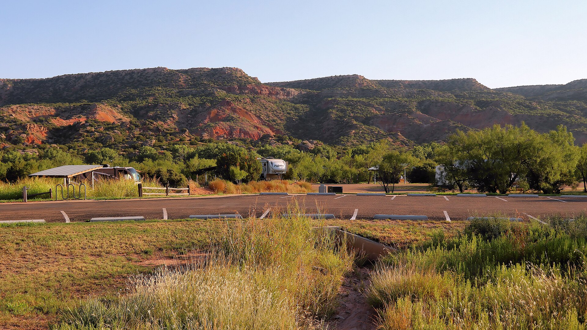
Randall County: Canyon, Palo Duro and the Edge of the High Plains
Randall County is where the level Llano Estacado suddenly falls away into Palo Duro Canyon, where cattle trails became college streets, and where a Panhandle county seat grew beside one of Texas' most dramatic landscapes.
Published August 10, 2026 · 10 min read
Randall County can look almost impossibly level until the land suddenly drops away. West and south of Amarillo, the Llano Estacado stretches in broad agricultural plains cut by roads, center-pivot fields and growing suburbs. Then, east of Canyon, the Prairie Dog Town Fork of the Red River has carved through those plains to expose the layered walls of Palo Duro Canyon. The contrast explains the county better than any boundary line: tabletop country above, canyon country below, and a county seat built where the two landscapes meet.
The county covers about 922 square miles in the central Texas Panhandle. The 2020 census counted 140,753 residents, and the Census Bureau estimated 152,351 in 2025. Much of that population lives in Canyon, the southern part of Amarillo, and fast-growing residential areas between the two. The rest of the county remains a mix of ranchland, farms, wildlife habitat and the broken country around Palo Duro.
The county name contains a 150-year-old spelling error
Texas created Randall County in 1876 from the vast territory that had once been attached to Bexar County. The intended namesake was Horace Randal, a Confederate brigadier general killed at the Battle of Jenkins' Ferry in Arkansas in 1864. Somewhere in the process of naming the new county, an extra letter was added. Randal became Randall, and the clerical error became permanent.
At the time, county government was mostly an idea on a map. Permanent Anglo settlement had barely begun. The Panhandle's bison herds had been devastated, the Red River War was ending, and ranchers were beginning to occupy land that had long been used by Indigenous peoples, especially Comanche, Kiowa and other Plains communities.
Palo Duro was home long before it was a park
Texas Parks and Wildlife traces human use of Palo Duro Canyon back roughly 12,000 years. Clovis and Folsom peoples hunted large game here, and later Apache, Comanche and Kiowa communities used the canyon's water, shelter, plants and game. Rock art, grinding surfaces and other archaeological evidence show that the canyon was not an empty wilderness waiting for settlement. It was a place people understood and depended on for thousands of years.
The canyon's name is Spanish. Palo Duro means 'hard wood,' a reference to the woody plants found in the canyon. Geologically, the feature is much older than its name. The headwaters of the Prairie Dog Town Fork of the Red River and weathering have cut through the eastern edge of the High Plains for roughly a million years, exposing bands of rock that represent more than 200 million years of geologic history.
The canyon begins in Randall County and extends southeast through Armstrong County and beyond. Its walls can rise hundreds of feet above the floor, with layers of red, orange, brown, yellow, gray and white rock creating the visual identity most Texans associate with the Panhandle. From the rim, the transition from flat prairie to canyon can happen in a few minutes of driving.
The Battle of Palo Duro Canyon changed the Panhandle
On September 28, 1874, during the Red River War, Colonel Ranald S. Mackenzie and the 4th U.S. Cavalry attacked a large encampment of Comanche, Kiowa and Cheyenne people in Palo Duro Canyon. Families escaped the immediate assault, but the soldiers captured roughly 1,400 horses, destroyed lodges and winter supplies, and killed most of the captured animals.
The consequences were severe. Without horses, food stores and shelter, many Native families could not remain on the plains through winter. The battle helped force the remaining southern Plains tribes onto reservations and opened the Panhandle to a rapid expansion of ranching. Any account of Randall County that jumps directly from 'empty plains' to cattle country misses that transition.
Charles Goodnight brought cattle into the canyon two years later
In 1876, Charles Goodnight drove about 1,600 Longhorns into Palo Duro Canyon and established the first headquarters of the JA Ranch. The canyon supplied water, shelter and winter protection that the exposed plains could not. Goodnight and his partner John Adair formally established the JA Ranch in 1877, and the operation eventually spread across more than a million acres of the Panhandle.
The JA was not the only giant ranch shaping the county. Leigh R. Dyer established a ranch headquarters near the meeting of Palo Duro and Tierra Blanca creeks in 1877. He later sold to Gunter, Munson and Summerfield, whose operation became the T Anchor Ranch. The old T Anchor headquarters is one of the most important surviving structures from the Panhandle's open-range era and is now preserved in Canyon.
Those ranches imposed a new geography on Randall County. Water sources, grazing blocks, fences, shipping routes and ranch headquarters became the organizing features of the landscape. The next major shift would come from the railroad and the town that became Canyon.
Tierra Blanca Creek joins Palo Duro Creek east of Canyon to form the Prairie Dog Town Fork of the Red River. The TexasDefined Tierra Blanca Creek guide follows this upstream watershed to legitimate public viewing areas at Buffalo Lake National Wildlife Refuge. It distinguishes the creek from the state park rather than promising a continuous public trail across privately held ranchland.
Canyon began with a dugout and a county-seat election
Lincoln Guy Conner settled near the future townsite in December 1887 and surveyed a town in 1889. His dugout served as a home, store and post office. When Randall County formally organized in July 1889, Canyon City was chosen as the county seat. The first courthouse was a simple temporary frame building that also hosted church services and community gatherings.
The name came from nearby Palo Duro Canyon rather than from a founder. As the town grew, freight initially arrived by wagon before rail connections improved access. Canyon developed as the governmental and commercial center for the surrounding ranch and farm country, and its identity became increasingly tied to education.
A college changed Canyon's scale and purpose
West Texas State Normal College opened in Canyon in 1910. It later became West Texas State Teachers College, West Texas State University and finally West Texas A&M University. The campus gave Randall County an institution whose influence reached far beyond the courthouse square. Teachers, students, researchers, performances, athletics and museums all made Canyon more than a ranch-service town.
The university remains one of the county's defining institutions. It anchors employment, cultural life and population growth in Canyon while connecting the city to the broader Amarillo metropolitan area. The campus also helps explain why Randall County has a different rhythm from many rural Panhandle counties: agricultural and ranching traditions remain visible, but higher education is equally central to local identity.
The Panhandle-Plains Historical Museum keeps the region's memory in Canyon
On the West Texas A&M campus, the Panhandle-Plains Historical Museum serves as one of the state's major regional museums. Its collections interpret archaeology, Indigenous history, ranching, petroleum, transportation, art and everyday life across the Texas Panhandle and surrounding plains. For a county series, the museum matters because Randall County is not merely a place where history happened; it became one of the places where Panhandle history is collected and explained.
The museum's location in Canyon also reflects the city's educational role. Ranch buildings, wagons, firearms, oil equipment, art and archaeological material that once would have been scattered across a vast region are gathered into a single institution within a few miles of the canyon itself.
The New Deal turned part of Palo Duro into a state park
Texas acquired land for Palo Duro Canyon State Park in 1933. Civilian Conservation Corps crews arrived soon afterward and spent years building the roads, trails, cabins and structures that made the canyon accessible to the public. The park opened in 1934 while work was still underway.
The CCC's most consequential achievement was physical access. Workers carved a winding road from the rim to the canyon floor, built trails and constructed El Coronado Lodge, now used as the visitor center. They used local stone and wood and followed the rustic design principles common to New Deal parks, creating structures intended to sit naturally within the landscape rather than overpower it.
Today Palo Duro Canyon State Park protects about 28,000 acres and is one of the largest and most recognizable parks in the Texas system. Hiking, camping, mountain biking, horseback riding and scenic drives draw visitors into a landscape that earlier generations knew as hunting ground, refuge, ranch country and battlefield.
The outdoor musical Texas turned the canyon into a stage
Since the 1960s, the outdoor musical Texas has used the canyon walls as scenery. Performances in the Pioneer Amphitheatre transformed Palo Duro into one of the state's best-known summer theater settings. The production mixes frontier themes, music and spectacle, but the larger effect is cultural: generations of visitors have come to associate Randall County with the experience of sitting under a Panhandle sky while the canyon becomes part of the stage.
That tourism economy matters to Canyon. Hotels, restaurants, shops, museums and university events all benefit from the steady flow of people headed toward the park. Randall County's economy is not based on tourism alone, but Palo Duro gives the county a statewide identity few Panhandle counties can match.
Buffalo Lake preserves a different kind of Panhandle landscape
In the southwestern part of Randall County, Buffalo Lake National Wildlife Refuge protects shortgrass prairie, playa and riparian habitat. Established in 1939, the refuge adds another layer to the county's public lands. Palo Duro is dramatic and vertical; Buffalo Lake is quieter and more representative of the open plains that surround it.
Together, the refuge and the state park show why the county's natural history cannot be reduced to the canyon alone. Water, grasslands, seasonal wetlands, creeks and breaks supported wildlife and human movement long before modern settlement, and those systems still shape the county outside its growing cities.
Randall County is now partly metropolitan
Modern Randall County includes a substantial portion of southern Amarillo as well as Canyon and smaller communities such as Lake Tanglewood and Timbercreek Canyon. Interstate 27 links Canyon directly to Amarillo and Lubbock, while U.S. Highway 60 and farm-to-market roads connect the county to agricultural areas across the Panhandle.
That location has fueled growth. The Census Bureau counted 140,753 residents in 2020 and estimated 152,351 in 2025, an increase of more than eight percent from the 2020 estimates base. New subdivisions, schools and commercial development continue to fill the corridor between Canyon and Amarillo.
Agriculture remains visible across the county, but the economic base now also includes education, health care, retail, construction, public administration and businesses tied to the Amarillo metro. Randall County has become a place where suburban growth and Panhandle ranch geography meet within a short drive.
A few Randall County facts worth remembering
- Randall County was created in 1876 and organized in 1889.
- The county was intended to honor Confederate general Horace Randal; the extra 'l' in Randall came from a clerical error.
- Palo Duro Canyon begins in Randall County and was used by people for thousands of years before European settlement.
- The Battle of Palo Duro Canyon on September 28, 1874 was a decisive event in the Red River War.
- Charles Goodnight brought cattle into Palo Duro Canyon in 1876 and helped establish the JA Ranch the following year.
- Canyon became the county seat when Randall County organized in 1889.
- West Texas State Normal College opened in Canyon in 1910 and evolved into West Texas A&M University.
- Texas acquired land for Palo Duro Canyon State Park in 1933, and CCC crews built many of the park's original roads, trails and structures.
- The 2020 census counted 140,753 residents in Randall County; the Census Bureau estimated 152,351 in 2025.
Why Randall County matters
Randall County explains the Texas Panhandle through contrast. The flat High Plains become a canyon. Indigenous homeland becomes military battlefield and then cattle country. A dugout town becomes a county seat and university community. New Deal crews turn ranchland into one of Texas' signature state parks. Amarillo's suburbs push south while ranch and farm roads continue only a few miles away.
The county is also a reminder that landscapes can hold several histories at once. Palo Duro is geology, archaeological record, Native homeland, battlefield, ranch shelter, public park and theater backdrop. Canyon is a courthouse town, a college town, a museum town and a gateway to that landscape.
Stand on the rim at Palo Duro and the county's story is visible in one view: the level plains behind you, the broken canyon below, ranch history in the distance and a modern city corridor only a short drive away. Randall County is not simply the place around Palo Duro Canyon. It is the meeting point between the Panhandle's most famous natural feature and the communities that grew around it.
Sources & verification
Research and official records
Research references support the editorial history and places described above. The official directories below help verify current county seats, census geography, property tax offices and vehicle services. Office personnel, contact details and links can change; check the agency website before traveling.
A claim-by-claim county-specific source list has not yet been published for this guide. The official starting points below are not a substitute for documented historical research.
Further county history research
Use the published county history as independent background reading, not as proof that every claim in this guide has been checked against that reference.
Museum and heritage guides
Museums connected to Randall County
Independent guides to collections, exhibits, visitor planning, accessibility and historical research. Verify each museum's current hours and admissions before traveling.
- Panhandle-Plains Historical Museum
Canyon, Randall County · Exhibits and visitor planning
Explore this county
State parks in Randall County
Visit-ready local park guides with official maps, facilities research and nearby trip ideas. Review current park alerts and reservations before setting out.
The Panhandle's immense red-rock canyon state park, often called the Grand Canyon of Texas, with more than 30 miles of hiking, biking and equestrian trails, dramatic rim-to-floor drives, CCC history and the iconic Lighthouse formation near Canyon and Amarillo.
Water parks & family aquatics
Water parks in Randall County
1 recorded indoor, outdoor or resort water-play facility in this county. Most outdoor venues operate seasonally and resort access may be restricted. Confirm the official schedule, admission eligibility and rides directly before visiting.
- Canyon Aqua Park
Canyon · Outdoor · Municipal water park
Session-based tickets and resident season passes
Local places to visit
More to explore in Randall County
These additional local places complement the park, museum, beach and other destination guides on this county page. They are not ranked. For events, swimming, tours or restricted properties, always check current visitor information before traveling.
- Arts & culture
TEXAS Outdoor Musical at Pioneer Amphitheater
Ticketed summer outdoor musical performed within Palo Duro Canyon State Park; the 2026 season is over, so check the operator for 2027 dates rather than planning an October show.
RV parks & campgrounds
RV camping around Randall County
TexasDefined currently connects 2 RV park or campground directory entries to this county. Verify hookups, rig limits, rates and reservations with the operator before travel.
Browse all Texas RV parks & campgrounds →Texas tournaments
Tournaments & competitions near Randall County
Browse TexasDefined’s statewide tournament directory across golf, rodeo, team sports, fishing, BBQ, chess, esports, academic competitions and more. County relationships are published only when a location can be assigned confidently; current dates, venues and entry details require organizer verification.
Texas high school football
High school football in Randall County
See current UIL football programs whose TEA school-directory records are in Randall County. Use the statewide finder to compare a specific high school or ISD before choosing where to live.
Open the statewide football finder →Loading current UIL football programs…
What this tells you: current 2026–28 UIL classification, football division, district and six-man/11-man format. School, ISD, city and county context is attached only when Texas Education Agency AskTED produces an unambiguous campus match; uncertain matches are deliberately omitted.
All-time state-final history: title and appearance totals use UIL’s Football All-Time Appearances table, supplemented with newer completed state-final rows from the official State Archives when that all-time table trails the latest archive. Totals appear only on an exact normalized UIL school-name match.
Recent state-final detail: the game-level list covers the eight completed UIL championship seasons from 2018–19 through 2025–26. No history badge does not mean a weak program; it means the source did not produce an exact normalized school-name match.
This is not a “best school” rating. Football placement and recent championship history are only parts of researching a program. Attendance zones, transfers, eligibility and campus assignments can change, so confirm an exact address and student eligibility with the school district and UIL before making a move.
Researched local football programs
Football history connected to Randall County
- Amarillo High Sandies football authority guide →
Four UIL state titles and the documented Sandies–Tascosa football series
- Caprock Longhorns football authority guide →
Verified Randall County campus, 2026 Longhorns history and current UIL alignment
- West Plains Wolves football authority guide →
West Plains High on Arden Road: Canyon ISD Wolves program founded 2022, Jeff Lofton promoted 2026 and state semifinal run in 2024
- Canyon Eagles football authority guide →
Randall County Canyon High: Matt Lovorn current coach source, 2026 District 2-4A DI race and Happy State Bank Stadium rivalry context
- Randall Raiders football authority guide →
Randall High Raiders: Dan Sherwood, 7-1 start through Oct. 23, Canyon rivalry win and official Randall High schedule links
Independent editorial guides. Game sites and district boundaries may span county lines; each listed school is linked by its campus county.