
County Guide
Tom Green County
Tom Green County is where three forks of the Concho meet, Fort Concho anchored a frontier town, sheep and cattle built fortunes, and modern San Angelo became a military, education and ranching center between the Hill Country and West Texas.
- Guide type
- Texas county guide
- County seat
- San Angelo, Texas
- Source check
- Official source checked
- Last reviewed
- August 4, 2026
Verified county profile
What the data says about Tom Green County
The 2020 Census counted 120,003 residents across about 1,522 square miles of land. Dividing those two Census figures gives roughly 78.8 residents per square mile.
Census geography also records about 19 square miles of water. Water represents approximately 1.2% of the county's mapped land-and-water area.
San Angelo is the verified county seat.
Texas Defined does not add an unsourced list of local communities. Additional places appear here only when the structured place directory contains a verified county relationship.
Understand the bigger picture
These Texas Explained guides add statewide context to the geography, settlement and infrastructure behind Tom Green County.
Explore Texas Explained →Historic places in this county
History you can visit in Tom Green County
Texas Defined currently connects 1 historic destination to this county guide.
Statewide context
Where Tom Green County sits in the county data
These ranks use the same Texas State Library and U.S. Census county dataset as the statewide comparison. A rank is shown only when that metric is available for the county and the comparison set; missing source values are excluded rather than estimated.
- 2020 population
- #38
- of 254 counties with source data
- land area
- #17
- of 254 counties with source data
- population density
- #55
- of 254 counties with source data
- water share
- #102
- of 254 counties with source data
Property tax rates
Taxing units in Tom Green County
Texas property taxes are imposed by separate local taxing units. The table below lists finalized statewide records associated with Tom Green County. A district appearing here does not mean every property in the county pays that district; use the exact parcel record to determine jurisdiction.
Checking finalized local tax rates…
Lakes and recreation
Fishing lakes in Tom Green County
These source-backed TexasDefined guides cover reservoirs and public lakes associated with this county. Review access and the managing agency's current notices before travel; a county link does not imply every part of a lake or every ramp lies within the county.
Explore all completed Texas fishing lake guides →At a glance
The county in numbers
- County seat
- San Angelo, Texas
- 2020 population
- 120,003
- Land area
- 1,522 sq. mi.
- Water area
- 19 sq. mi.
- Population density
- 78.8 / sq. mi.
- Water share
- 1.2%
County questions
Quick answers about Tom Green County
What is the county seat of Tom Green County?
San Angelo, Texas is the county seat of Tom Green County.
How many people live in Tom Green County?
The 2020 U.S. Census counted 120,003 residents in Tom Green County.
How densely populated is Tom Green County?
Using the 2020 Census population and Census land-area figure, Tom Green County has about 78.8 residents per square mile. This is a derived density figure, not a separate Census estimate.
What cities and communities are in Tom Green County?
Tom Green County includes communities such as San Angelo. City limits, mailing addresses and county boundaries do not always match, so verify an exact address when county jurisdiction matters.
Where do I look up property taxes in Tom Green County?
TexasDefined has not yet published a county-specific property-tax guide for Tom Green County because its local source verification is still incomplete. Use the statewide county property-tax directory and the official local office links on this page while verification is pending.
How do I research industries and employers around Tom Green County?
Start with the Texas industries hub to understand the statewide sector system, then use Made in Texas and local sources to verify which companies and facilities are actually tied to Tom Green County. TexasDefined does not treat a statewide industry page as proof that a specific employer operates in this county.
How do I find official Tom Green County government information?
Start with the official Tom Green County website for county departments, services, courts and records. For property values, exemptions and protests use the appraisal district; for tax bills and payments use the office designated by the taxing unit. TexasDefined links to the statewide property-tax county directory until this county-specific tax guide passes source verification.
Property taxes
County property-tax resources
Property-tax questions in Tom Green County involve several separate authorities. Until the county-specific tax guide passes source verification, use the statewide county property-tax directory plus the official appraisal and tax-office resources shown here.
Property & county services
Official local resources
Property appraisal
The Comptroller directory entry is undated or more than two years old. This guide does not display potentially outdated individual contact details. Follow the official county directory link to verify the current office.
Comptroller office listing updated 2021-09-22; confirm contact details with the district before visiting.
Tax office
Tax assessor-collector: Becky Robles
Phone: 325-659-6529
113 W. Beauregard Ave. San Angelo, Texas 76903-5834
Comptroller office listing updated 2025-02-19; confirm vehicle and tax service details with the office before visiting.
County feature
The story of Tom Green County
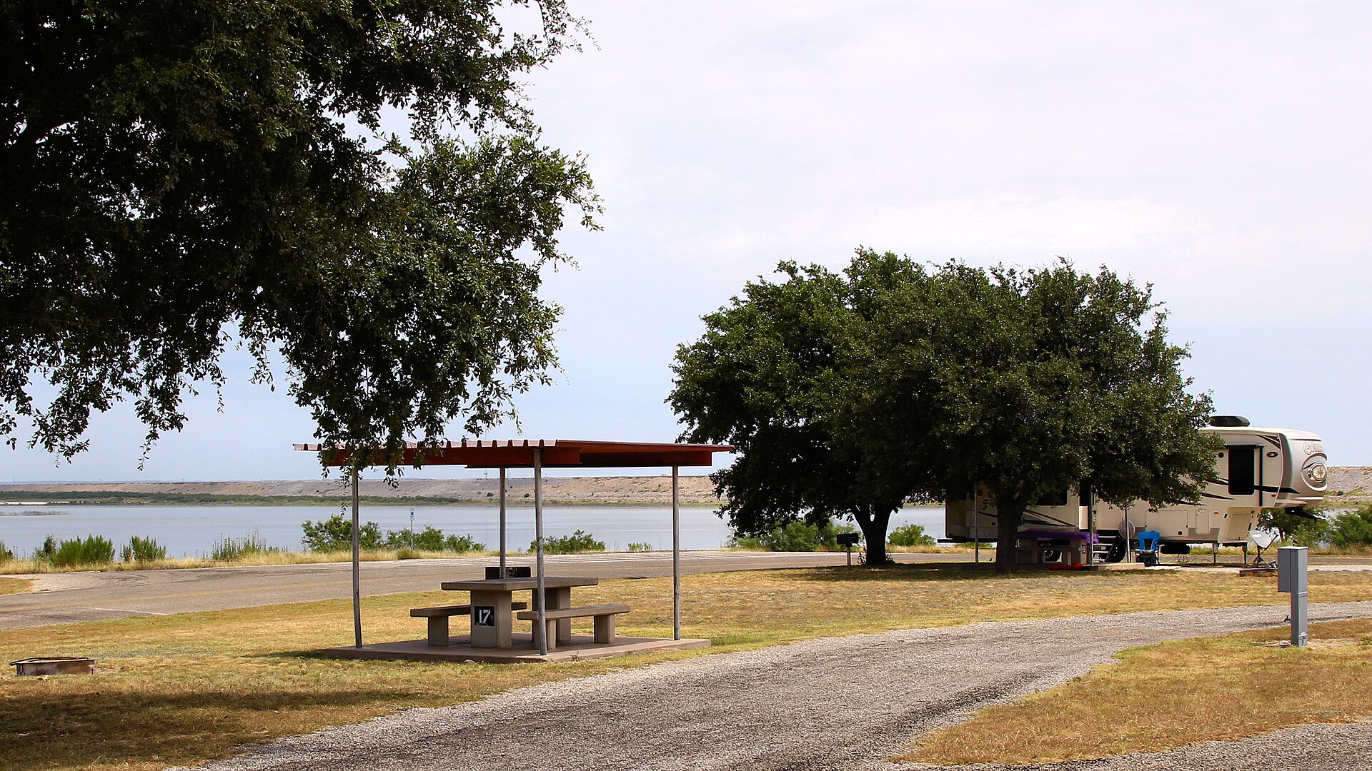
Tom Green County: San Angelo, the Concho and a Frontier City at the Crossroads
Tom Green County is where three forks of the Concho meet, Fort Concho anchored a frontier town, sheep and cattle built fortunes, and modern San Angelo became a military, education and ranching center between the Hill Country and West Texas.
Published August 10, 2026 · 10 min read
Tom Green County sits in one of those parts of Texas where regional labels begin to blur. The Hill Country lies to the southeast, the Edwards Plateau rises nearby, the Permian Basin is farther west, and the plains stretch north. San Angelo grew at the meeting point, beside the forks of the Concho River, and became the kind of city that serves an enormous rural hinterland: courthouse town, military town, ranching center, college town and trading point all at once.
The county covers about 1,540 square miles in west-central Texas. The Concho system is its defining natural feature. The North, Middle and South Concho rivers drain different parts of the county and join around San Angelo before flowing east. The 2020 census counted 120,003 residents in Tom Green County, and the Census Bureau estimated 120,602 in 2025. Most live in and around San Angelo, while communities such as Grape Creek, Carlsbad, Christoval and Wall keep the county tied to farms, ranches and smaller-town West Texas.
The county began much larger than the county on today's map
Texas created Tom Green County in 1874 and named it for Thomas Green, a soldier and political figure who had served in the Texas Revolution, the Republic of Texas Congress and later the Confederate military. The original county was immense, extending across a huge section of western Texas before later counties were carved from it. Modern Tom Green County is only a fraction of that early jurisdiction.
The county seat was first at Ben Ficklin, a settlement south of present-day San Angelo. Flooding on the South Concho River destroyed much of Ben Ficklin in 1882, and voters moved the county seat to San Angelo the following year. That decision fixed the political center beside the military post and commercial settlement that had already become the region's strongest town.
The Concho River gave the country its name and its first durable geography
Water explains why people gathered here long before courthouses and railroads. Archaeological evidence across the region shows thousands of years of Indigenous presence. The Concho River and its tributaries offered water, game and travel routes through an otherwise dry landscape. Jumano people were among the groups associated with the river system, and Spanish travelers later followed the same waterways.
The name Concho comes from the Spanish word for shell. Freshwater mussels in the river produced iridescent pearls that drew attention from Spanish explorers and later settlers. The famous 'Concho pearls' became part of San Angelo's identity, and the shell imagery still appears in local names and civic references.
Even today the river is more than scenery. San Angelo's downtown river corridor, reservoirs and park system all reflect the same basic fact that shaped earlier settlement: dependable water determines where communities can grow in this part of Texas.
Fort Concho created the anchor for modern San Angelo
The U.S. Army established Fort Concho in 1867 along the Concho River. Its mission was to protect frontier settlements and travelers, patrol routes across West Texas and support military operations in a region the federal government was trying to control. The post eventually included at least forty buildings spread across more than 1,600 acres, many constructed from local limestone.
Fort Concho became an important station for several frontier units. The 4th and 10th Cavalry served there, and elements of all four Black Army regiments later known as Buffalo Soldiers were stationed at the post during its active years. Commanders associated with Fort Concho included Ranald Mackenzie and Benjamin Grierson. At full strength the fort supported roughly 400 to 500 soldiers and the civilians whose work kept the post operating.
A civilian settlement grew nearby because forts create demand. Merchants, freight operators, saloons, hotels, ranchers and families clustered around the post. The town was first called Santa Angela and later San Angelo. When the Army abandoned Fort Concho in 1889, the settlement no longer depended on the fort for survival. It had become the commercial center of the Concho country.
Ranching made the county richer than its dry landscape first suggests
Cattle were important from the beginning, but sheep and wool became equally important to the local economy. The broad grasslands, dry climate and access to regional markets made the Concho country especially suited to ranching. San Angelo developed into a major livestock, wool and mohair center, serving ranches spread across a wide radius.
That regional role explains why San Angelo has long felt larger than its county population alone would suggest. Ranchers from neighboring counties came to buy equipment, bank, sell livestock, see doctors, attend school and conduct business. Auction barns, feed stores, warehouses and financial institutions all grew from the city's function as a service center for the surrounding countryside.
Agriculture remains part of Tom Green County's identity even as the economy has diversified. Cattle, sheep, goats, cotton and other crops still connect the city to the land beyond its subdivisions. The annual rhythm of livestock shows, ranch work and agricultural education keeps the older economy visible inside a modern regional city.
Railroads turned a frontier market into a regional city
Rail connections strengthened San Angelo's position in the late nineteenth and early twentieth centuries. Freight could move more efficiently, livestock and wool could reach distant markets, and manufactured goods could come west in greater volume. The town's commercial streets, warehouses and hotels grew around that exchange.
San Angelo's downtown still reflects the era when a regional center needed banks, theaters, stores, hotels and public buildings close together. Later highways spread commerce outward, but the city's original role remains recognizable: it is a place where a large part of west-central Texas comes to do business.
Goodfellow gave the county a second military identity
Fort Concho's military era ended in 1889, but Tom Green County returned to a major defense role during the buildup to World War II. The federal government established what became Goodfellow Field in 1940 after San Angelo civic leaders offered land and infrastructure for a training base. The first students arrived in early 1941.
Goodfellow initially trained pilots. During World War II thousands of aviators passed through the installation. Its mission later shifted away from flying and toward intelligence, surveillance, reconnaissance and technical training. Today Goodfellow Air Force Base is home to the 17th Training Wing and trains personnel from across the Department of Defense, including intelligence professionals and military firefighters.
That continuing mission gives San Angelo a military presence very different from Fort Concho's cavalry era but rooted in the same strategic geography. The county has twice built a durable relationship with military training, first on the nineteenth-century frontier and then in the modern national-security system.
San Angelo built its own college when the state chose another city
Education became another pillar of the county in the 1920s. San Angelo tried unsuccessfully to win the new Texas Technological College, which ultimately went to Lubbock. Rather than abandon the idea of higher education, local residents funded their own institution. San Angelo Junior College opened in 1928 with 112 students, supported by local contributions and a county tax.
The school became San Angelo College, then Angelo State College in 1965 and Angelo State University in 1969. Its growth changed the city's demographic and cultural life, adding students, faculty, athletics, research and professional education to an economy once dominated by ranching, trade and the military.
Angelo State's history is unusually local in origin. The institution exists because residents decided a West Texas regional center needed a college and were willing to finance one themselves. That civic decision still shapes Tom Green County nearly a century later.
Reservoirs changed the relationship between the county and its rivers
Flood control and water storage reshaped the Concho system in the twentieth century. The U.S. Army Corps of Engineers completed O.C. Fisher Reservoir on the North Concho River in 1952. Twin Buttes Reservoir later added storage on the Middle and South Concho system southwest of San Angelo.
The reservoirs are practical infrastructure in a dry county, but they also changed recreation and habitat. San Angelo State Park now surrounds much of O.C. Fisher Reservoir. The 7,677-acre park opened in 1995 and offers roughly fifty miles of multiuse trails, camping, fishing and wildlife viewing.
The park is especially appropriate as a visual symbol for Tom Green County because it brings several layers of the county together in one place: the Concho watershed, open West Texas grassland, ranching heritage, reservoir engineering and public recreation. The park also maintains bison and members of the Official Texas State Longhorn Herd.
The state park contains a much older story underfoot
San Angelo State Park's landscape reaches far deeper into time than the city beside it. A two-mile Dinosaur Trail passes fossilized trackways left by Permian-age animals that lived before the dinosaurs. The tracks are a reminder that the county's exposed rocks preserve a world hundreds of millions of years older than the frontier history most visitors associate with San Angelo.
The park also sits near the meeting point of several ecological regions. Texas Parks and Wildlife describes influences from the High Plains, Hill Country, Rolling Plains and Trans-Pecos. That overlap helps explain the variety of plants and wildlife found around the reservoir and river corridor.
Fort Concho survives because San Angelo chose to keep it
Many frontier posts disappeared after the Army left. Fort Concho did not. The City of San Angelo owns and operates the National Historic Landmark site, where original and reconstructed buildings preserve the physical scale of the post. Barracks, officers' quarters and other limestone structures give visitors something rare in Texas: a military frontier landscape that can still be walked rather than merely imagined.
The fort's interpretation also keeps the Buffalo Soldier story central. The Black cavalry and infantry units that served in West Texas were not side notes to the frontier Army; they were a substantial part of it. Fort Concho's surviving records and buildings make Tom Green County one of the state's most important places for understanding that history.
Modern Tom Green County is a regional service center
Today's county economy is broader than ranching and defense. Health care, education, retail, construction, government, tourism and professional services all play major roles. San Angelo serves patients, students, shoppers and businesses from counties that may be an hour or more away. That regional reach is one reason the city supports institutions and services normally associated with larger metropolitan areas.
The county's population has grown more slowly in recent years than some booming Texas metros, but it remains remarkably stable for a West Texas regional center. The Census Bureau counted 120,003 residents in 2020 and estimated 120,602 in 2025. That steadiness reflects an economy with several anchors rather than a single commodity cycle.
A few Tom Green County facts worth remembering
- Tom Green County was created in 1874 and named for Thomas Green, a Texas Revolution veteran and public official.
- The county originally covered a much larger area of West Texas before later counties were organized from its territory.
- San Angelo became the county seat in 1883 after flooding devastated the earlier seat at Ben Ficklin.
- Fort Concho was established in 1867 and served as an important frontier post until 1889.
- Elements of all four Buffalo Soldier regiments served at Fort Concho during the post's active years.
- San Angelo Junior College opened in 1928 and evolved into Angelo State University.
- Goodfellow was established in 1940 and today trains military intelligence, surveillance, reconnaissance and fire-protection professionals.
- O.C. Fisher Reservoir was completed in 1952 for flood control on the North Concho River.
- San Angelo State Park opened in 1995 and protects 7,677 acres around much of the reservoir.
- The 2020 census counted 120,003 residents in Tom Green County; the Census Bureau estimated 120,602 in 2025.
Why Tom Green County matters
Tom Green County explains how a West Texas regional center is built. Water comes first: three forks of the Concho provide the geography. Then comes Fort Concho, which creates a market and settlement. Ranching, wool and livestock give the town an economy. Railroads enlarge the trade radius. A locally funded college adds education. Goodfellow restores a military mission in a new form. Reservoirs turn flood control into public landscape, and San Angelo State Park preserves both natural and cultural history on the city's edge.
The county also resists easy regional labels. It is not quite the Permian Basin, not quite the Hill Country, not quite the High Plains and not quite the Trans-Pecos. Its strength comes from sitting between them. San Angelo became the place where those landscapes and economies meet.
Follow the Concho through the county and the story becomes visible: ancient trackways, Indigenous travel routes, freshwater mussels and pearls, limestone barracks, livestock country, college lawns, military classrooms and a modern riverfront city. Tom Green County is a crossroads not because two highways happen to intersect there, but because West Texas has been converging on the Concho for centuries.
Sources & verification
Research and official records
Research references support the editorial history and places described above. The official directories below help verify current county seats, census geography, property tax offices and vehicle services. Office personnel, contact details and links can change; check the agency website before traveling.
A claim-by-claim county-specific source list has not yet been published for this guide. The official starting points below are not a substitute for documented historical research.
Further county history research
Use the published county history as independent background reading, not as proof that every claim in this guide has been checked against that reference.
Museum and heritage guides
Museums connected to Tom Green County
Independent guides to collections, exhibits, visitor planning, accessibility and historical research. Verify each museum's current hours and admissions before traveling.
- San Angelo Museum of Fine Arts
San Angelo, Tom Green County · Exhibits and visitor planning
Explore this county
State parks in Tom Green County
Visit-ready local park guides with official maps, facilities research and nearby trip ideas. Review current park alerts and reservations before setting out.
A large Concho Valley park on O.C. Fisher Reservoir with miles of hiking, biking and equestrian trails, wildlife habitat and a landscape tied to the official Texas State Longhorn Herd.
Water parks & family aquatics
Water parks in Tom Green County
1 recorded indoor, outdoor or resort water-play facility in this county. Most outdoor venues operate seasonally and resort access may be restricted. Confirm the official schedule, admission eligibility and rides directly before visiting.
- San Angelo Municipal Pool Water Slides
San Angelo · Outdoor · Municipal water park
Public City of San Angelo pool admission; 2026 published rates $6 ages 3–64, $4 seniors 65+, free ages two and younger
Local places to visit
More to explore in Tom Green County
These additional local places complement the park, museum, beach and other destination guides on this county page. They are not ranked. For events, swimming, tours or restricted properties, always check current visitor information before traveling.
- Parks & recreation
International Water Lily Collection
Free public water-lily collection at Civic League Park in San Angelo, with flowering displays concentrated in the warmer months.
RV parks & campgrounds
RV camping around Tom Green County
TexasDefined currently connects 3 RV park or campground directory entries to this county. Verify hookups, rig limits, rates and reservations with the operator before travel.
- Concho Valley RV ParkSan Angelo, Texas
- San Angelo State Park RV LoopSan Angelo, Texas
- Spring Creek Marina & RV ParkSan Angelo, Texas
Major annual events
Events worth planning around in Tom Green County
Texas Defined links only to event guides backed by organizer or equivalent first-party evidence. Future recurrence-derived dates are labeled on the event guide.
Texas tournaments
Tournaments & competitions near Tom Green County
Browse TexasDefined’s statewide tournament directory across golf, rodeo, team sports, fishing, BBQ, chess, esports, academic competitions and more. County relationships are published only when a location can be assigned confidently; current dates, venues and entry details require organizer verification.
Texas high school football
High school football in Tom Green County
See current UIL football programs whose TEA school-directory records are in Tom Green County. Use the statewide finder to compare a specific high school or ISD before choosing where to live.
Open the statewide football finder →Loading current UIL football programs…
What this tells you: current 2026–28 UIL classification, football division, district and six-man/11-man format. School, ISD, city and county context is attached only when Texas Education Agency AskTED produces an unambiguous campus match; uncertain matches are deliberately omitted.
All-time state-final history: title and appearance totals use UIL’s Football All-Time Appearances table, supplemented with newer completed state-final rows from the official State Archives when that all-time table trails the latest archive. Totals appear only on an exact normalized UIL school-name match.
Recent state-final detail: the game-level list covers the eight completed UIL championship seasons from 2018–19 through 2025–26. No history badge does not mean a weak program; it means the source did not produce an exact normalized school-name match.
This is not a “best school” rating. Football placement and recent championship history are only parts of researching a program. Attendance zones, transfers, eligibility and campus assignments can change, so confirm an exact address and student eligibility with the school district and UIL before making a move.
Researched local football programs
Football history connected to Tom Green County
- Christoval Cougars football authority guide →
Tom Green County 2A Division I District 4; official 2026 calendar and Tanner McLean district appointment
Independent editorial guides. Game sites and district boundaries may span county lines; each listed school is linked by its campus county.