Skip to content
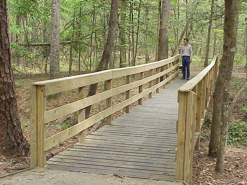
Wooden bridge along the Stephen F. Austin Experimental Forest interpretive trail at Jack Creek, photographed for the USDA Forest Service site

Piney Woods · Outdoors & Wildlife

Stephen F. Austin Experimental Forest Interpretive Trails

A 2,560-acre USDA research forest southwest of Nacogdoches with a paved 0.8-mile Jack Creek Loop and a 1.5-mile natural-surface Management Loop on the operator's detailed map; the agency's descriptive webpage instead calls the latter 2.0 miles.

Photography: USDA Forest Service, Southern Research Station · official SFA Experimental Forest trail photograph · U.S. government work; source: research.fs.usda.gov/srs/forestsandranges/locations/austin

Quick trip facts

Stephen F. Austin Experimental Forest Interpretive Trails at a glance

Where is Stephen F. Austin Experimental Forest Interpretive Trails?
Stephen F. Austin Experimental Forest Interpretive Trails is near Nacogdoches, Texas, in Nacogdoches County.
When is the best time to visit Stephen F. Austin Experimental Forest Interpretive Trails?
Year-round, especially spring and autumn for comfortable hiking; mosquitoes and humidity can be significant in summer.
Do I need to plan ahead for Stephen F. Austin Experimental Forest Interpretive Trails?
Day use only. The USDA Forest Service reports public trails open during daylight hours for foot and wheelchair traffic, with pets leashed. The 0.8-mile Jack Creek Loop offers a surfaced accessible route; the Management Loop is unpaved and more strenuous. The detailed official trail map calls it 1.5 miles, while the webpage describes 2.0 miles; navigate by the downloadable map and signs. Check current Forest Service closure orders, storm damage and path conditions. The trail and research-area order PDFs still linked from the USDA overview say they expired December 31, 2024; they must not be treated as proof of restrictions currently in force.
Who manages Stephen F. Austin Experimental Forest Interpretive Trails?
USDA Forest Service Southern Research Station

The experience

Exploring Stephen F. Austin Experimental Forest Interpretive Trails

Unlike a recreational-only park, the Stephen F. Austin Experimental Forest was established by an act of Congress and entered the federal experimental forest system in 1945. The USDA Forest Service identifies its research themes as silviculture, wildlife habitat and forest management. Recreational interpretation became an expanded objective in 1990; the two-loop interpretive system was completed in 1997.

Most of the tract is mature bottomland hardwood forest, with pine and mixed forest on higher ground. Jack Creek runs through the low-lying section, supporting moisture-loving plants and diverse wildlife. This is an outdoor classroom, not a manicured university garden; visitors can learn why differences in soil, flooding, shade and management affect habitats and species.

The shorter Jack Creek Loop is the Forest Service's paved 0.8-mile interpretive trail, designed for universal access, subject to actual surface and weather conditions. The operator's posted detailed trail map labels the natural-surface Management Loop as 1.5 miles, plus named cutoff and spur trails; it labels the 400 Loop as an additional 1.4-mile unpaved road and totals all marked paths at 4.3 miles. However, the Forest Service's descriptive webpage calls the Management Loop 2.0 miles and the two-loop system about 2.8 miles. These operator documents conflict. For navigating, download the current detailed trail map and follow posted signs; confirm route lengths directly with the Forest Service before relying on them.

The operator lists accessible parking, restrooms at the trail entrance, picnic tables and a self-guided information kiosk. Water fountains are around the start rather than all along the trails. The USDA visitor overview directs visitors to leash pets and states that firearms are prohibited. Its linked forest-order PDFs, however, specify December 31, 2024 expiration dates; verify enforceable restrictions on the National Forests and Grasslands in Texas closure-orders page or with the ranger district rather than assuming those PDFs are current. The forest is administered by the USDA, not Stephen F. Austin State University's campus gardens; keep the park and campus travel addresses distinct.

The details

Planning your visit

Area
Nacogdoches, Texas
Best season
Year-round, especially spring and autumn for comfortable hiking; mosquitoes and humidity can be significant in summer.
Entry & reservations
Day use only. The USDA Forest Service reports public trails open during daylight hours for foot and wheelchair traffic, with pets leashed. The 0.8-mile Jack Creek Loop offers a surfaced accessible route; the Management Loop is unpaved and more strenuous. The detailed official trail map calls it 1.5 miles, while the webpage describes 2.0 miles; navigate by the downloadable map and signs. Check current Forest Service closure orders, storm damage and path conditions. The trail and research-area order PDFs still linked from the USDA overview say they expired December 31, 2024; they must not be treated as proof of restrictions currently in force.
Accessibility
USFS describes 0.8 mile of Jack Creek Loop as surfaced and barrier-free; the more rugged, natural-surface Management Loop should not be characterized as universally accessible. Confirm current conditions and restroom access before relying on the designation.
Getting there
From Nacogdoches Loop 224, drive about 6.5 miles west on State Highway 7; turn south onto FM 2782 and continue about 2.4 miles to the Forest Service entrance on the right, then follow signs to interpretive-trail parking. Verify roads and closures before departure.

Evidence and citations

Research sources

Read the original operator records and supporting research for this guide.

Independent Texas Defined research

Why this place matters

A 2,560-acre USDA research forest southwest of Nacogdoches with a paved 0.8-mile Jack Creek Loop and a natural-surface Management Loop shown as 1.5 miles on the detailed federal trail map, despite a differing 2.0-mile description on the agency webpage.

Our trip-planning assessment

Recommended visit
Allow 1–2 hours for Jack Creek Loop, trailhead orientation and interpretive stops; budget more time for the longer Management Loop, travel and changing trail conditions.
Physical effort
Easy-to-moderate on surfaced Jack Creek; more strenuous on the unpaved Management Loop
Weather exposure
Fully outdoors
Planning required
Moderate
Family fit
Good for families selecting suitable trails, seasons and wildlife observation.
First-visit value
Provides a firsthand look at how experimental-forest research, native ecosystems and universally accessible trail design intersect.

Itineraries that fit real trips

1–2 hours

Quick orientation

  1. Download the current USDA trail map and check conditions at the kiosk
  2. Follow the surfaced Jack Creek Loop for a short interpretive walk
  3. Use signs to identify mature pines, hardwoods and Jack Creek habitat

3–5 hours

Focused half-day

  1. Study the natural-surface Management Loop and its cutoff options on the official map
  2. Explore signed forest-management interpretation without leaving designated trails
  3. Return to the trailhead in daylight and carry your own water

1 day

Full Piney Woods history outing

  1. Start with the 0.8-mile Jack Creek Loop and compare its accessible trail design
  2. If conditions and ability permit, add the natural-surface Management Loop
  3. Connect the research-forest story to the regional Nacogdoches–San Augustine history itinerary

Practical questions

Frequently asked questions about Stephen F. Austin Experimental Forest Interpretive Trails

Is this a university garden?
No. It is a federal experimental research forest managed by the USDA Forest Service, distinct from SFA's campus gardens.Check official details ↗
How long are the loops?
The official USDA detailed trail map lists the paved Jack Creek Loop at 0.8 mile and the natural-surface Management Loop at 1.5 miles, plus cutoff/spur trails and an unpaved 400 Loop, totaling 4.3 miles of named paths. The USDA descriptive webpage still says 2.0 miles for Management Loop; follow the downloadable map and current onsite trail signs.Check official details ↗
Where can I download the trail map?
The U.S. Forest Service hosts a PDF titled Stephen F. Austin Interpretive Trail. It distinguishes paved and natural surfaces and marks restrooms, parking and cutoffs; check current forest orders before visiting.Check official details ↗
Can wheelchair users use the trail?
The Jack Creek Loop was built for universal accessibility; check current surface and closures with the Forest Service.Check official details ↗
How can I check current closures and restrictions?
Review the Forest Service closure-order listings for the National Forests and Grasslands in Texas and contact the managing office when unclear. The forest-order PDFs linked on the USDA Experimental Forest overview list December 31, 2024 expiration dates, so do not interpret them as evidence of active 2026 orders.Check official details ↗
Are dogs allowed?
The USDA says pets must be leashed; check posted forest rules for any exceptions.Check official details ↗
Are restrooms available?
The operator lists accessible restrooms at the trail entrance and drinking fountains near the parking area.Check official details ↗

Verify before you travel

Primary sources and fact checks

Our itineraries and recommendations are independent editorial judgments. Hours, ticket prices, access, closures and conditions belong to the official operators and can change after our most recent review.

Last source review:

Around the area

What to do near Stephen F. Austin Experimental Forest Interpretive Trails

Start at the signed Forest Service interpretive trailhead: Jack Creek is paved, while the longer Management Loop has a natural surface. Confirm current trail conditions and download the official map before leaving town.

NearbyAttractions close by

Easy additions that fit naturally around the main stop.

Eat nearbyWhere to eat and drink

Dining districts and food areas worth building into the same outing.

  • Food and water planning

    Carry drinking water and food from Nacogdoches; the agency lists water fountains near the trailhead, not along the loops.

Stay nearbyWhere to stay

The most practical lodging areas for minimizing driving and maximizing time on the ground.

  • Nacogdoches lodging

    Nacogdoches is the most direct overnight base for this trailhead southwest of town. Confirm the drive to the forest entrance on FM 2782.

Explore moreNeighborhoods and districts

Nearby parts of the city that add character, shopping, history or nightlife.

  • Forest landscapes

    Compare Jack Creek's moist hardwood bottomlands with the research forest's pine and pine–hardwood uplands.

With kidsFamily-friendly stops

Good nearby additions when the itinerary includes younger travelers.

  • Jack Creek family walk

    Use the surfaced 0.8-mile interpretive loop for a shorter outing; check accessibility conditions before relying on the designation.

Go fartherWorthwhile side trips

Places that justify extending the visit beyond the immediate area.

Plan the route

Explore related places

Editorially paired stops near Stephen F. Austin Experimental Forest Interpretive Trails appear first, followed by nearby destinations. Distances are approximate straight-line miles.

  • Nacogdoches · Nacogdoches County · Piney Woods

    Alazan Bayou Wildlife Management Area

    Alazan Bayou WMA protects 2,063 acres of bottomland hardwood forest, old fields and floodplain habitat along the Angelina River and associated East Texas bayous south of Nacogdoches.

    Best season: Fall through spring for cooler wildlife viewing; winter and early spring can bring flooded bottomland conditions and strong waterfowl use.Updated Sep 2026
    • Angelina River bottomlands
    • Mature hardwood forest
    • Waterfowl and woodland wildlife
    Explore this place

    Approx. 4 miles away

  • Nacogdoches · Nacogdoches County · Piney Woods

    Nacogdoches Railroad Depot

    The City of Nacogdoches operates its restored 1911 Southern Pacific depot as a free transportation museum interpreting the passengers, workers and rail connections that transformed one of Texas's oldest cities.

    Best season: Year-round museum; spring and fall are ideal for adding the depot to a larger historic Nacogdoches walking and driving itinerary.Updated Aug 2026
    • 1911 Southern Pacific depot
    • Free transportation museum
    • Railroad workers and passengers
    Explore this place

    Approx. 9 miles away

  • Nacogdoches · Nacogdoches County · Piney Woods

    Nacogdoches

    Nacogdoches is an East Texas university town with deep Spanish and Mexican-era roots, brick-paved historic streets, museums, gardens, trails and Stephen F. Austin State University, making the self-described oldest town in Texas a complete Piney Woods destination.

    Best season: Spring for azaleas and gardens, fall through spring for downtown and trail walking, and summer mornings for outdoor stops before the East Texas heat and humidity buildUpdated Sep 2026
    • historic downtown
    • oldest-town history
    • Stephen F. Austin State University
    Explore this place

    Approx. 9 miles away

  • Nacogdoches · Nacogdoches County · Piney Woods

    Sterne-Hoya House Museum and Library

    A circa-1830 Nacogdoches historic house associated with Adolphus Sterne, the Texas Revolution and the later von der Hoya family. The museum is currently closed for preservation-related maintenance.

    Updated Oct 2026
    • 1830 dogtrot house
    • Adolphus Sterne and Revolution-era Texas
    • von der Hoya household and Victorian furnishings
    Explore this place

    Approx. 9 miles away

  • Nacogdoches · Nacogdoches County · Piney Woods

    Nacogdoches Downtown Historic District

    A walkable National Register historic district at the heart of one of East Texas's oldest settlements, linking Caddo history, Spanish and Mexican-era roads, brick streets, public art and surviving downtown landmarks.

    Best season: Autumn through spring for comfortable downtown walking, with local events at other times of year.Updated Oct 2026
    • National Register-listed downtown district
    • Brick-paved Main Street
    • Charles Bright Visitor Center and Plaza Principal
    Explore this place

    Approx. 9 miles away

  • Nacogdoches · Nacogdoches County · Piney Woods

    Zion Hill Baptist Church Historic Site

    A restored 1914 Diedrich Rulfs-designed landmark and former home of one of Nacogdoches' oldest Black Baptist congregations, now offering free historic-site tours and community programming.

    Best season: Fall through spring for outdoor architecture and public-street walks; the church hosts tours on its own published schedule.Updated Oct 2026
    • Founded 1878 by Reverend Lawson Reed
    • 1914 Gothic and Victorian Revival church
    • Architect Diedrich Rulfs
    Explore this place

    Approx. 10 miles away

Read next

More from Outdoors & Wildlife