

Texas Explained
Rio Grande in Texas: River Guide, Big Bend, Reservoirs & Border History
Follow the Rio Grande through Texas from El Paso and Big Bend to Amistad, Laredo, Falcon Reservoir and the Lower Rio Grande Valley, with river access, history, ecology and water-management context.
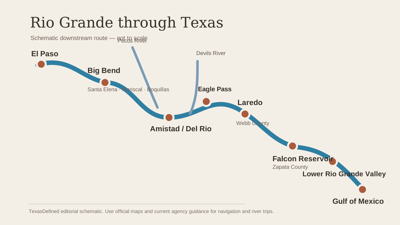
The Rio Grande is not one Texas landscape and not just a line on a border map. In Texas it begins as the international river at El Paso, bends through some of the most remote desert in the United States, cuts the great canyons of Big Bend, receives the Pecos and Devils rivers, widens into Amistad, passes Eagle Pass and Laredo, is stored again at Falcon, then enters the irrigated Lower Rio Grande Valley before reaching the Gulf of Mexico. To understand the river, you have to follow that entire journey.
That journey also explains why the Rio Grande is unlike every other major Texas river. The water arriving in Texas has already crossed Colorado and New Mexico. Major tributaries arrive from both the United States and Mexico. Reservoirs are operated internationally. Cities and farms depend on allocations governed by interstate compacts and international agreements. At the same time, the river is a recreation corridor, wildlife habitat, historic travel route and one of the state's defining physical features.
Rio Grande quick guide
- Texas reach: the river forms the U.S.–Mexico boundary from El Paso to the Gulf of Mexico.
- Texas basin scale: the Rio Grande has the largest watershed area in Texas of any major river basin.
- Signature Texas scenery: Santa Elena, Mariscal and Boquillas canyons in Big Bend.
- Major Texas tributaries: the Pecos and Devils rivers, plus smaller desert and lower-valley streams.
- Major international reservoirs: Amistad near Del Rio and Falcon southeast of Laredo.
- Major Texas cities on or near the river: El Paso, Presidio, Del Rio, Eagle Pass, Laredo, Roma, Rio Grande City and Brownsville-area communities.
- Best-known recreation corridor: Big Bend and the Rio Grande Wild & Scenic River, where current permit and safety rules should always be checked before launching.
- Lower-river identity: irrigation, agriculture, border communities, wildlife habitat and one of North America's most distinctive subtropical transition zones.
Where the Rio Grande begins—and where Texas enters the story
The Rio Grande rises in the San Juan Mountains of Colorado and flows south through New Mexico before reaching the El Paso area. The Texas Water Development Board identifies it as a 1,896-mile river overall, with 889 miles associated with Texas. From El Paso downstream, the river is the international boundary between the United States and Mexico until it reaches the Gulf.
That upstream geography matters. El Paso does not sit near the beginning of the river; it sits far downstream from the headwaters. Snowpack, reservoirs, irrigation and water-management decisions in Colorado and New Mexico are already part of the river's story before the channel becomes the Texas–Mexico boundary.
El Paso: where the river becomes Texas' international river
At El Paso, the Rio Grande enters one of the most urbanized reaches of its Texas course. The river passes between El Paso and Ciudad Juárez, linking two large cities that share a desert environment and a water system that cannot be understood within a single municipal boundary. Levees, diversion works, irrigation infrastructure and highly managed flows make this stretch very different from the free-looking canyon river farther downstream.
For a traveler, El Paso is useful because it makes the international character of the river immediately visible. For a water planner, it demonstrates something even more important: the Rio Grande is already an allocated and engineered system long before it reaches the remote landscapes most visitors associate with West Texas.
Presidio and the Rio Conchos: a major change in the river
Farther downstream, the Rio Grande reaches the Presidio–Ojinaga area, where the Rio Conchos enters from Mexico. The Conchos drains a large part of northern Mexico and is one of the most consequential tributaries in the lower river system. After this confluence, the Rio Grande continues toward the Big Bend country with a different hydrologic story than the river above Presidio.
This is one reason the Texas reach cannot be explained only with Texas tributaries. Water can arrive from an upstream U.S. state or from a Mexican watershed, then continue past Texas communities whose supply and ecology depend on the combined system.
Big Bend: the Rio Grande becomes a canyon river
Big Bend is the stretch that turns the Rio Grande from an abstract boundary into one of Texas' most dramatic landscapes. The river arcs around the southern edge of Big Bend National Park and cuts three major canyons—Santa Elena, Mariscal and Boquillas—through resistant rock. Here, the international boundary can be a ribbon of water only a short distance across, while cliffs rise hundreds or more than a thousand feet above the channel.
The National Park Service treats the Rio Grande as a central part of the park experience. Visitors can reach overlooks, short hiking trails, historic sites and river-access points, while properly prepared river runners can float designated segments. Conditions vary enormously with flow, weather and the length of trip, so a beautiful canyon view should not be confused with easy river travel.
Santa Elena Canyon: the classic Rio Grande view
Santa Elena Canyon is the most recognizable Rio Grande scene in Texas. The river slices through a massive limestone wall along the western side of Big Bend National Park, with Mexico on one side and Texas on the other. A popular trail approaches the canyon mouth, while river trips can enter the gorge when conditions and regulations permit.
The important planning point is that river conditions are not fixed. A section that looks gentle at one flow can become technically different after a rise, and low water can create its own problems. Anyone planning a float should use current National Park Service river information rather than treating a general travel article as a launch guide.
Mariscal and Boquillas: the river keeps changing
Mariscal Canyon is shorter and more remote, while Boquillas Canyon carries the river past enormous limestone walls on the eastern side of the park. NPS describes Boquillas as one of the park's three major Rio Grande canyons and provides both an overlook and a trail to the canyon entrance. Downstream, the protected Rio Grande Wild & Scenic River continues beyond the national park boundary.
Near Boquillas, the river is also part of a legal international crossing. The Boquillas Port of Entry allows eligible visitors with proper documents to cross to Boquillas del Carmen, Mexico, when the port is open. Hours and requirements can change, so visitors should verify the current NPS and border-entry information before planning around the crossing.
Can you paddle the Rio Grande in Big Bend?
Yes, but the answer depends on the reach, water level, trip length and current regulations. NPS identifies multiple river-trip options, from the popular Santa Elena segment to longer Boquillas and Lower Canyons trips. A backcountry use permit is required before placing or operating watercraft on the Rio Grande within Big Bend National Park, and additional rules apply to overnight trips downstream in the Wild & Scenic River corridor.
That is why this guide treats paddling as a planning category rather than a promise that any particular section is floatable on a given date. The Rio Grande is highly variable. Check current flow, weather, access, permit and take-out information directly with the National Park Service before launching.
The Pecos River joins the Rio Grande above Amistad
East of Big Bend, the Pecos River enters the Rio Grande near the upper end of Amistad Reservoir. The Pecos drains an enormous arid watershed stretching through New Mexico and West Texas. Its confluence is one of the best reminders that the Rio Grande basin is a network, not a single channel.
The Pecos also brings its own interstate water-management history. The Pecos River Compact between New Mexico and Texas is one of several agreements that shape water in the larger Rio Grande system. A map that follows only the main stem misses these legal and hydrologic connections.
The Devils River adds one of Texas' clearest spring-fed tributaries
The Devils River enters the Rio Grande system at Amistad from the north. It is famous for clear water, limestone country and a relatively undeveloped corridor. That character contrasts sharply with the Rio Grande's broad international watershed, but the two become one system at the reservoir.
This confluence is a good example of why Texas rivers can look unrelated in photographs while still being directly connected. A spring-fed tributary, a desert-border river and a large international reservoir can all be parts of the same basin.
Amistad: where the Rio Grande becomes a vast international reservoir
Near Del Rio and Ciudad Acuña, Amistad Dam impounds the Rio Grande into one of the river's two major international reservoirs in Texas. The International Boundary and Water Commission says Amistad was built primarily for flood control and water-conservation storage for both countries, with hydroelectric generation also part of the project.
For travelers, Amistad National Recreation Area transforms the river into a broad reservoir landscape of open water, desert shoreline and limestone. Boating, fishing and shoreline recreation make this one of the most accessible places to experience the Rio Grande basin without undertaking a remote canyon trip.
For the water system, the reservoir has another role entirely: it stores and regulates water in a basin where runoff is limited and highly variable. The same place can therefore be understood as a recreation destination, an international infrastructure project and a central piece of downstream water management.
Eagle Pass and Maverick County: the river as city edge
Below Amistad, the Rio Grande passes Eagle Pass and Piedras Negras. Here the river again becomes an urban border rather than a remote desert corridor. Bridges, water-supply infrastructure, trade and daily cross-border relationships dominate the landscape more than canyon scenery.
This is also where the river's role as a municipal resource becomes impossible to separate from its political role. The same channel that defines the international line also supports communities on both banks.
Laredo and Webb County: one of the river's major urban reaches
At Laredo and Nuevo Laredo, the Rio Grande passes one of the largest trade gateways on the U.S.–Mexico border. The river is a water source, an international boundary and the physical line around which a binational metropolitan area developed. Upstream releases, reservoir storage, water quality and drought conditions all matter here.
A statewide guide should not treat Laredo as a side note. The city shows how the Rio Grande shifts identities again: from national-park river to reservoir system to a heavily used urban waterway supporting one of North America's most important commercial corridors.
Falcon Reservoir: the second great storage point
Farther downstream, Falcon Dam creates Falcon International Reservoir between Texas and Tamaulipas. Like Amistad, Falcon is jointly tied to flood control, conservation storage and hydropower. Together, Amistad and Falcon are the two dominant storage projects on the international reach of the river.
Falcon also marks a geographic transition. Upstream, much of the river passes through dry South Texas brush country. Downstream, the river increasingly enters the agricultural and urban system associated with the Lower Rio Grande Valley.
Roma and Rio Grande City: historic settlements along the lower river
Starr County contains some of the Rio Grande's strongest surviving borderland townscapes. Roma's historic district looks across the river toward Mexico, while Rio Grande City grew from a river crossing and trade corridor. These communities help explain why the lower river was a transportation and settlement axis long before modern highways and international bridges.
The river here is neither the canyon wilderness of Big Bend nor the large open water of Amistad. It is a lived border landscape, surrounded by towns, ranch country, irrigated land and a long record of movement between both sides.
The Lower Rio Grande Valley: irrigation changed the landscape
By the time the river reaches Hidalgo and Cameron counties, the surrounding landscape has changed again. Large irrigation networks helped transform the Lower Rio Grande Valley into one of Texas' major agricultural regions, historically supporting citrus, vegetables and other crops. Cities such as Mission, McAllen, Pharr, Edinburg, Harlingen and Brownsville grew within this larger river-and-irrigation economy even when not every city sits directly on the main channel.
The term 'Valley' can be misleading to visitors expecting a steep mountain valley. The Lower Rio Grande Valley is largely a broad, low coastal plain. Its identity comes from the river, irrigation, subtropical climate, border culture and ecological transition rather than dramatic relief.
Why the lower river is an ecological crossroads
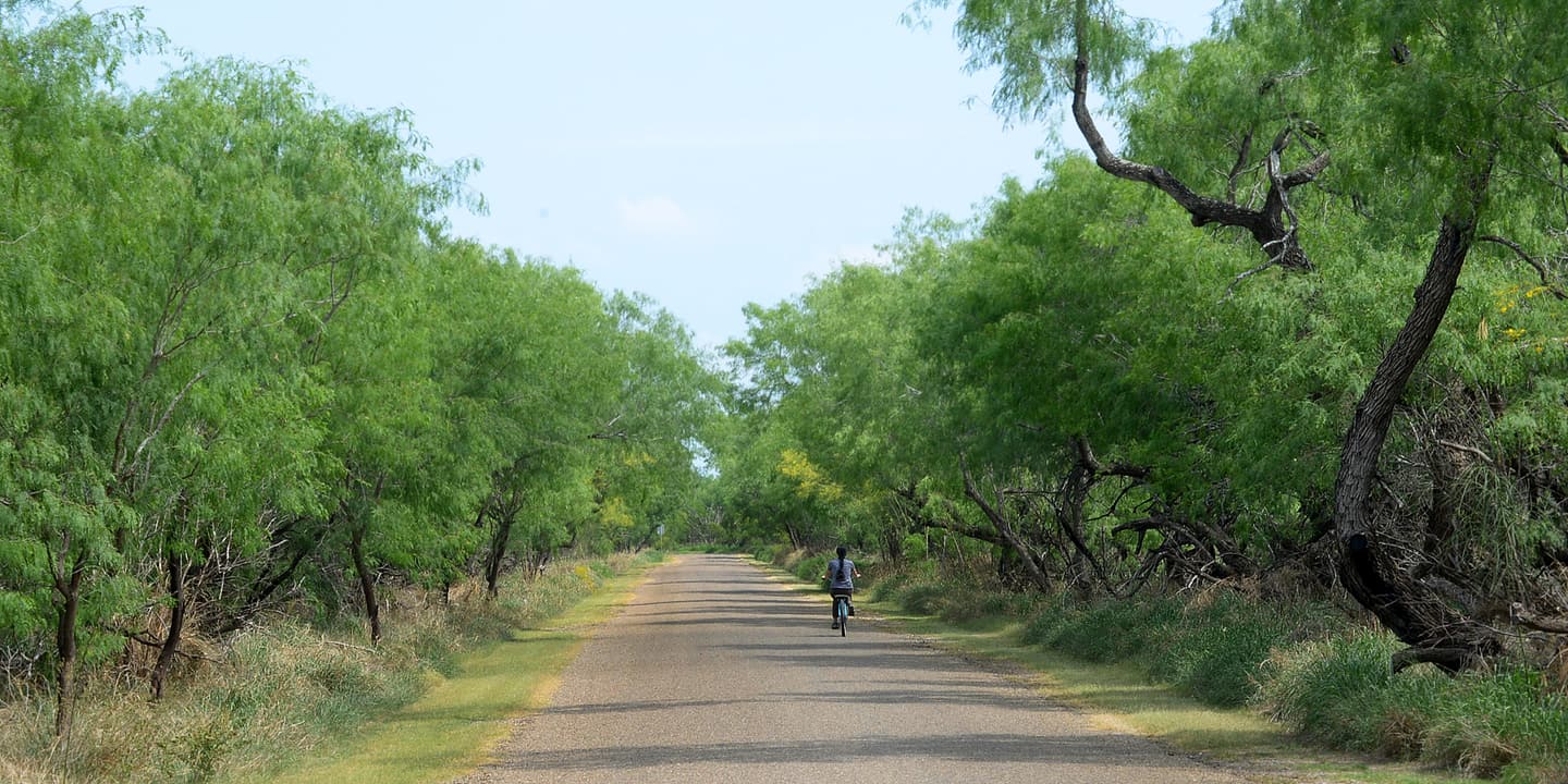
The lower basin sits where temperate and subtropical species overlap. Rio Grande floodplain forests, resacas, thornscrub and restored habitat support wildlife that many visitors associate more with northeastern Mexico than with the rest of Texas. The region is especially famous for birding because numerous tropical species reach or approach the northern edge of their U.S. range here.
Bentsen-Rio Grande Valley State Park and other World Birding Center sites preserve pieces of this habitat. They are important not because they show a pristine version of the entire river, but because they protect remnants of a floodplain ecosystem heavily altered elsewhere by agriculture, cities, roads, levees and water-control infrastructure.
Does the Rio Grande always reach the Gulf?
The river's Gulf outlet is the end of the basin, but the mouth is dynamic. Sediment, waves, storms, tides, channel conditions and low flows can all change the final connection between river and sea. In drought and low-flow periods, the river's lower reach can look very different from the broad, continuously flowing river people imagine from a map.
That variability is part of the central Rio Grande story: a river can define nearly 900 miles of the Texas border and still have relatively low watershed yield compared with wetter Texas basins.
Why such a huge basin can produce relatively little water
TWDB lists the Rio Grande as the largest major river basin by area in Texas, with 49,387 square miles of basin area inside the state. Yet the agency lists average annual flow far below several smaller, wetter East Texas systems. The reason is climate: much of the watershed is arid or semiarid, so evaporation is high and runoff is limited.
This distinction matters whenever someone assumes a large basin must mean a large dependable supply. Basin area tells you how much land drains toward the river. It does not tell you how much water that land will reliably produce.
The treaties and compacts are part of the river itself
The Rio Grande cannot be explained with geography alone. Water in the system is apportioned through a layered legal framework that includes the Rio Grande Compact among Colorado, New Mexico and Texas; the Pecos River Compact between New Mexico and Texas; the 1906 Convention; and the 1944 water treaty between the United States and Mexico.
Those agreements answer different questions in different parts of the system, but the practical point is simple: Texas is not free to treat the entire river as water originating within its own borders. Upstream states and Mexico are part of the same operating reality.
What Amistad and Falcon actually do
The two international reservoirs are sometimes described mainly as large fishing and boating lakes. They are much more than that. Their dams store water, help manage floods and support hydroelectric generation while the countries maintain separate ownership accounting within a shared reservoir system.
IBWC publishes current Rio Grande flow and reservoir data, including Amistad and Falcon storage. Those real-time conditions are more useful for understanding the system today than a fixed percentage copied into an evergreen article, because reservoir levels can change materially with drought, releases and inflows.
Fishing, boating and swimming: what visitors should know
The Rio Grande offers fishing and boating opportunities, but rules and practical conditions vary widely by location. Amistad and Falcon are large reservoir fisheries. Big Bend river trips operate under National Park Service rules. Other reaches may have limited public access, strong currents, private-property constraints, border considerations or water-quality questions.
Swimming should never be treated as universally safe simply because a reach is scenic. Check local conditions, access rules and agency advisories. In remote West Texas, heat and rescue distance can be as important as the water itself. In reservoir country, wind and open-water exposure may be the larger hazard.
Where to experience the Rio Grande in Texas
- El Paso — best for understanding the urban international river and upper Texas reach.
- Presidio — best for seeing the river near the Rio Conchos confluence and entering the Big Bend borderlands.
- Santa Elena Canyon — the classic Big Bend canyon view and one of the most recognizable river landscapes in Texas.
- Boquillas Canyon and Rio Grande Village — strong options for hiking, overlooks and understanding the eastern Big Bend river corridor.
- Amistad National Recreation Area — best for broad reservoir scenery, boating and a close look at the managed international river near Del Rio.
- Eagle Pass and Laredo — best for understanding the Rio Grande as an urban water source, border and trade corridor.
- Falcon Reservoir — another major place to see the river transformed into international storage and recreation water.
- Roma and Rio Grande City — strong choices for borderland history tied directly to the river.
- Bentsen-Rio Grande Valley State Park and the lower valley — best for the basin's subtropical ecology and birdlife.
A short history of how the river became the boundary
The Rio Grande was not always accepted as the international boundary of Texas. After the Texas Revolution, the Republic of Texas claimed the Rio Grande as its southern and western boundary, while Mexico disputed that claim and treated the Nueces River as the relevant boundary in the northeast. The contested land between the Nueces and Rio Grande became one of the central geographic disputes preceding the U.S.–Mexican War.
The Treaty of Guadalupe Hidalgo in 1848 established the Rio Grande as the international boundary from the Gulf upstream toward the El Paso area, with later agreements and boundary work addressing the practical problem of using a shifting river as a political line. Floods and channel changes made that work anything but simple.
Why the river is also a Texas cultural corridor
Communities along the Rio Grande do not fit neatly into a story of two separate worlds divided by water. Long before the modern border, Indigenous routes, Spanish settlements, ranching networks, trade and family ties crossed what later became the international line. El Paso and Juárez, Eagle Pass and Piedras Negras, Laredo and Nuevo Laredo, Roma and Ciudad Miguel Alemán, and Brownsville and Matamoros all illustrate forms of paired border geography.
That does not erase the legal significance of the border. It explains why the river is simultaneously a national boundary and a regional connector—two roles that can exist at the same time.
How to read the Rio Grande on a Texas map
Start at El Paso and move downstream rather than looking only for famous attractions. Trace the river southeast toward Presidio and the Rio Conchos, then through the Big Bend arc. Continue east to the Pecos and Devils confluences and Amistad. From there, follow the river past Eagle Pass and Laredo to Falcon Reservoir, then into Starr, Hidalgo and Cameron counties before the Gulf.
That route reveals the river's logic. Desert city becomes remote canyon. Canyon becomes reservoir. Reservoir becomes urban border. Urban border becomes another reservoir, then an irrigated subtropical plain. No single photograph can represent the Rio Grande because the river keeps changing what kind of Texas landscape it occupies.
Frequently asked questions about the Rio Grande in Texas
Where is the prettiest part of the Rio Grande in Texas? For dramatic scenery, the Big Bend canyon country—especially Santa Elena Canyon—is the best-known reach. Amistad offers a very different kind of broad blue-water desert scenery, while the lower valley is more important for ecology and bird habitat than canyon views.
Can you float the Rio Grande? Yes in designated reaches, especially around Big Bend, but permits, flows, access and skill requirements matter. Use current NPS river-trip and regulation pages before planning a launch.
Is the Rio Grande entirely in Texas? No. It begins in Colorado, crosses New Mexico and then forms the Texas–Mexico boundary from El Paso to the Gulf. Its watershed also includes major tributaries in Mexico.
What are the biggest Rio Grande reservoirs in Texas? Amistad International Reservoir near Del Rio and Falcon International Reservoir downstream of Laredo are the two major international storage reservoirs on the Texas reach.
What are the most important Texas tributaries? The Pecos and Devils rivers are the most prominent Texas tributaries commonly highlighted in statewide basin descriptions, while many smaller creeks and channels also contribute to the system.
Why is the Rio Grande sometimes low? Much of the basin is arid or semiarid, and the river is heavily allocated and managed. Snowpack, drought, tributary inflows, reservoir storage, irrigation and upstream obligations all influence the amount of water moving through a particular reach.
What the Rio Grande teaches about Texas
- A river can be a natural system, international boundary, water-supply network and recreation corridor at the same time.
- The biggest watershed in Texas does not produce the state's biggest average flow because climate matters as much as area.
- Big Bend's famous canyons are only one chapter in a river that also passes major cities, reservoirs and agricultural regions.
- Pecos, Devils and Mexican tributaries show why the river must be understood as a basin rather than a single channel.
- Amistad and Falcon make storage, flood control and international management visible on the landscape.
- The Lower Rio Grande Valley shows how irrigation, wildlife habitat, urban growth and river management overlap.
- Texas cannot understand this river by looking only inside Texas; the Rio Grande is interstate and international from its headwaters to its mouth.
One river, several different Texases
The Rio Grande is one of the best geographic guides to Texas because it refuses to stay one thing. At El Paso it is an urban desert river. In Big Bend it is a canyon-cutting wilderness corridor. At Amistad and Falcon it becomes international infrastructure and open water. At Eagle Pass and Laredo it is a city edge and water source. In the Lower Rio Grande Valley it supports irrigation, subtropical habitat and a dense chain of border communities before reaching the Gulf.
Follow the river from beginning to end and the central lesson is not that the Rio Grande divides Texas from Mexico. It is that this one water system connects an extraordinary range of landscapes, communities and histories—and that understanding those connections is the only way to understand the river itself.
From watershed map to a real visit
Texas's Rio Grande combines managed international water, remote desert canyons, crossings, reservoirs and lower-valley irrigation; each is a distinct visitor setting. The river forms an international boundary, so obey both U.S. laws and relevant border regulations. Do not treat a scenic overlook at Big Bend, an Amistad boat ramp and the international lower river as interchangeable access.
Named access and a responsible trip plan
Big Bend National Park's Santa Elena, Mariscal and Boquillas Canyon journeys have site-specific launch, take-out, difficulty and permit requirements; check NPS before choosing a route. NPS requires a backcountry-use permit before a watercraft is used on the Rio Grande within Big Bend National Park, except for day-use inner tubes. **That day-use permit exemption does not authorize inner tubes through major canyons:** the same official regulation prohibits inner tubes in Santa Elena, Mariscal and the Lower Canyons. The park also specifies personal flotation device requirements, extra paddles, waste containment and other safety equipment. Never describe a permit exemption as unrestricted access.
Fishing, species and harvest decisions
Fishing in NPS-managed reaches, Amistad and Falcon Reservoir involves separate permit, license, species and boating rules, including potential cross-border and waterbody-specific issues. Never borrow reservoir bag limits or fishing access from another location without checking TPWD and the managing federal authority for the chosen reach.
Camping, RV options and overnight permissions
Inside Big Bend, use properly permitted national-park camping and river-trip itineraries. On Amistad or Falcon, research individual permitted campgrounds and boat launches; riverbank camping in remote private or international areas is not automatically lawful. Confirm drinking water, border safety, heat and cell coverage.
Worthwhile nearby stops and trip logistics
First-time visitors can plan land-based Big Bend viewpoints before considering specialized multi-day water trips. Guided programs and interpretation explain canyon geology and human history; visitors should avoid an unprepared river crossing or entry where no designated exit exists.
Visitor questions specific to the Rio Grande
Do I need a permit to canoe the Rio Grande in Big Bend?
Yes. NPS requires a backcountry-use permit for watercraft on the Rio Grande within the park. Day-use inner tubes have a permit exemption, but inner tubes are prohibited in Santa Elena, Mariscal and the Lower Canyons; the exemption must not be read as permission to float these canyons.
Is the Rio Grande a single float trip from El Paso to the coast?
No. It crosses remote canyons, dams, international reservoirs, urban areas and managed irrigation systems with different legal requirements and access.
Can I cross the river into Mexico while paddling?
An international river crossing raises immigration and border requirements; follow official border and park instructions, not casual trip recommendations.
Where can families learn about the Rio Grande without boating?
Publicly managed Big Bend park overlooks and interpretive facilities are suitable planning anchors when the park is open and conditions allow.
Does a river gauge mean the canyon is safe?
No. Water levels are only one risk input; assess weather upstream, canyon rescue access, boating skill, permits and local NPS alerts.
Official source checks and review schedule
This river recreation research was revised October 12, 2026. The official managing sources below support named route and park examples. Current water levels, local access, commercial operations, regulation exceptions and seasonal conditions must still be verified for the trip date. An agency source's unchanged webpage is not proof that an editorial fact-check was completed. This page is not a navigational or flood clearance document.
Recommended citation: TexasDefined.com, Rio Grande river guide, recreation and visitor review October 12, 2026.
Image credit: Adbar · CC BY-SA 3.0 · Wikimedia Commons · https://commons.wikimedia.org/wiki/File:Big_Bend_Rio_Grande.jpg · License: https://creativecommons.org/licenses/by-sa/3.0/
Primary source: Texas Water Development Board ↗
Sources and further reading
Plan Your Visit
Places connected to this story
Destinations explicitly tied to this article in the Texas Defined guide.
Terlingua · Brewster County
Big Bend National Park
Explore Big Bend's Chisos Mountains, Chihuahuan Desert and Rio Grande canyons using current NPS road closures, campground reservations and correct 2026 Chisos Basin construction status.
Best season: Fall through spring for hiking and lower-elevation exploring; summer heat can be extreme, so warm-season plans should favor early starts, higher elevations and conservative distancesUpdated Oct 2026- Chisos Basin access remains available despite canceled renovation closure
- Santa Elena Canyon: Terlingua Creek crossing varies with floods
- Ross Maxwell Scenic Drive: check closure and turnaround
Del Rio · Val Verde County
Amistad National Recreation Area
Plan boating, shoreline fishing and desert camping at the Rio Grande's international Amistad reservoir near Del Rio, where fluctuating water levels change boat-ramp access and NPS lake-use passes govern registered vessels.
Best season: Fall through spring for mild weather; summer is very hotUpdated Oct 2026- Amistad Reservoir's desert-water scenery and boating
- Ramp-by-ramp access subject to rapidly changing lake elevation
- Distinct NPS Lake Use Pass requirement for registered vessels
Mission · Hidalgo County
Bentsen-Rio Grande Valley State Park
The World Birding Center headquarters near Mission, protecting Lower Rio Grande Valley resaca, woodland and thornscrub habitat with exceptional birding, car-free trails and wildlife viewing.
Best season: September through April is the park's busy season; fall through spring generally brings milder weather and strong migration and birding.Updated Sep 2026- World Birding Center headquarters
- About 360 recorded bird species
- Hawk Observation Tower and migration viewing

From the magazine
More stories to read next
Lakes & Rivers
Rio Grande Wild and Scenic River in Texas: Canyons, River Permits and Trip Planning
October 17, 2026 · About 4 minutes
