Skip to content

Coastal Bend · Day trips

Best Day Trips From Corpus Christi, Texas

An intentionally varied geographic shortlist of parks, towns, history and outdoor trips. Some farther results are long driving days or better as overnights; compare real road times before choosing.

Source-backed options30

Distance window18–150 straight-line miles

OrderingGeographic distance

Straight-line distances are screening estimates from central Corpus Christi. They are not road miles or drive-time promises. Use the “Check current drive” links in the map and guide sections below for current Google Maps routing, road mileage and travel-time estimates.

A better starting point than the mileage list

These researched destinations have full TexasDefined guides in the current catalog. Each choice includes the operating authority's visitor source and live driving directions. This is independent editorial selection, not a paid ranking. Distances elsewhere on this page are geographic screening estimates—not road times.

Optional tours and activities

Find a guided experience that fits your trip

Compare guided tours and activities in the Corpus Christi market. These optional experiences are separate from the state parks and independently researched day-trip stops above; check the actual tour location, dates and transport before booking.

Affiliate disclosure: TexasDefined may earn a commission on a qualifying Viator booking, at no extra cost to you. Listing, availability, prices and booking conditions are controlled by Viator and its suppliers. Editorial choices are independent of affiliate links.

Map & routes

Find it on the map and compare routes

Closer geographic choices

8 full TexasDefined guides in this geographic band

About 18 geographic miles

Corpus Christi

Corpus Christi · Nueces County

Whitecap Beach

A North Padre Island Gulf beach at the end of Whitecap Boulevard with both pedestrian-only shoreline and vehicle-access areas near the Corpus Christi beach corridor.

Best season: October through May for milder weather; summer works for beach days with heat, storms and surf conditions checked closelyUpdated Sep 2026
  • Open-Gulf beach
  • Padre Island & South Texas setting
  • Corpus Christi access
Explore this place
Check current drive from Corpus Christi ↗

About 19 geographic miles

Port Aransas

Port Aransas · Nueces County

Tony Amos City Beach

A named Port Aransas city-beach area honoring longtime coastal scientist Tony Amos, within the broader Mustang Island public beach corridor south of town.

Best season: March through May and September through November for milder beach weather; summer is busiest and hottestUpdated Sep 2026
  • Open-Gulf beach
  • Mustang Island & Corpus Christi Bay setting
  • Port Aransas access
Explore this place
Check current drive from Corpus Christi ↗

About 21 geographic miles

Port Aransas

Port Aransas · Nueces County

Port Aransas

Port Aransas is a Mustang Island Gulf Coast town built around accessible beaches, fishing, shorebird habitat, a busy ship channel, island neighborhoods and routes to Mustang Island State Park and the Coastal Bend.

Best season: Late fall through spring for milder temperatures, birding and fishing; summer for beach holidays with heat, surf and tropical-weather precautions.Updated Oct 2026
  • Port Aransas Beach
  • Mustang Island
  • birdwatching
Explore this place
Check current drive from Corpus Christi ↗

About 25 geographic miles

Corpus Christi

Corpus Christi · Nueces County

Malaquite Beach

The vehicle-free beach beside Malaquite Visitor Center in Padre Island National Seashore, offering a quieter developed access point with parking, restrooms and showers.

Best season: October through May for milder weather; summer works for beach days with heat, storms and surf conditions checked closelyUpdated Sep 2026
  • National-seashore coastline
  • Padre Island & South Texas setting
  • Corpus Christi access
Explore this place
Check current drive from Corpus Christi ↗

About 26 geographic miles

Rockport

Rockport · Aransas County

Rockport

Rockport is an Aransas Bay coastal town where fishing, birding, a public beach, maritime history, a long-running arts community and access to the bays of the Coastal Bend support a complete Gulf Coast weekend rather than a single-purpose beach stop.

Best season: Fall through spring for birding, fishing and mild waterfront weather; summer for beach and water trips with heat and tropical-weather planningUpdated Sep 2026
  • Aransas Bay
  • Rockport Beach
  • Texas Maritime Museum
Explore this place
Check current drive from Corpus Christi ↗

About 26 geographic miles

Rockport

Rockport · Aransas County

Texas Maritime Museum

The Texas Maritime Museum in Rockport interprets the state's long relationship with the Gulf through shipbuilding, shipwrecks, fishing, offshore industry, Indigenous coastal history and maritime commerce.

Updated Oct 2026
  • Texas maritime history
  • Shipbuilding and shipwrecks
  • 2026 wooden shipbuilding and Spain’s American Revolution role
Explore this place
Check current drive from Corpus Christi ↗

About 28 geographic miles

Fulton

Fulton · Aransas County

Fulton Mansion State Historic Site

The elaborate 1870s mansion overlooking Aransas Bay reflects the wealth, technology and ambitions of George and Harriet Fulton. It is an architectural centerpiece for a Rockport-Fulton trip and a window into affluent Gulf Coast life after the Civil War.

Best season: Year-round; spring and fall are usually the most comfortable for outdoor portions of a visit.Updated Oct 2026
  • Victorian architecture
  • Gulf Coast history
  • 19th-century technology
Explore this place
Check current drive from Corpus Christi ↗

About 29 geographic miles

Fulton

Fulton · Aransas County

Fulton Beach Park

A small Aransas Bay waterfront park in Fulton that works as a relaxed shoreline, picnic and fishing stop near the town's harbor and seafood district.

Best season: March through May and September through November for milder beach weather; summer is busiest and hottestUpdated Sep 2026
  • Protected-bay beach
  • Coastal Bend setting
  • Fulton access
Explore this place
Check current drive from Corpus Christi ↗

Middle-distance choices · check the road route

7 full TexasDefined guides in this geographic band

About 58 geographic miles

Goliad

Goliad · Goliad County

Presidio La Bahía

A restored Spanish colonial presidio in Goliad associated with the Texas Revolution and the Goliad Massacre, with a chapel, museum and fortified courtyard overlooking the San Antonio River valley.

Best season: Fall through spring for comfortable historic-site touringUpdated Oct 2026
  • Spanish colonial presidio
  • Our Lady of Loreto Chapel
  • Goliad Campaign history
Explore this place
Check current drive from Corpus Christi ↗

About 59 geographic miles

Goliad

Goliad · Goliad County

Goliad State Park & Historic Site

A South Texas history park centered on Mission Espíritu Santo, with restored Spanish colonial architecture, museum exhibits and a San Antonio River setting tied to the broader Goliad story.

Best season: Fall through spring for comfortable walking and regional history touringUpdated Oct 2026
  • Mission Espíritu Santo reconstruction
  • Spanish colonial and Indigenous history
  • San Antonio River setting
Explore this place
Check current drive from Corpus Christi ↗

About 62 geographic miles

Fannin

Fannin · Goliad County

Fannin Battleground State Historic Site

The site preserves the landscape associated with the 1836 Battle of Coleto, where James Fannin's command was surrounded during the Texas Revolution. Pair it with Presidio La Bahía to follow the events that led from the Coleto surrender to the Goliad executions.

Best season: Year-round; spring and fall are usually the most comfortable for outdoor portions of a visit.Updated Oct 2026
  • Texas Revolution
  • James Fannin
  • Goliad campaign
Explore this place
Check current drive from Corpus Christi ↗

About 73 geographic miles

Port O'Connor

Port O'Connor · Calhoun County

Sunday Beach

A remote beach area on Matagorda Island open to the public for beachcombing, fishing, birding and camping, reached only by private or charter boat.

Best season: Fall through spring for comfortable exploring and birding; summer requires more heat, storm and insect planningUpdated Sep 2026
  • Barrier-island shoreline
  • Coastal Bend setting
  • Port O'Connor access
Explore this place
Check current drive from Corpus Christi ↗

About 74 geographic miles

Three Rivers

Three Rivers · McMullen County

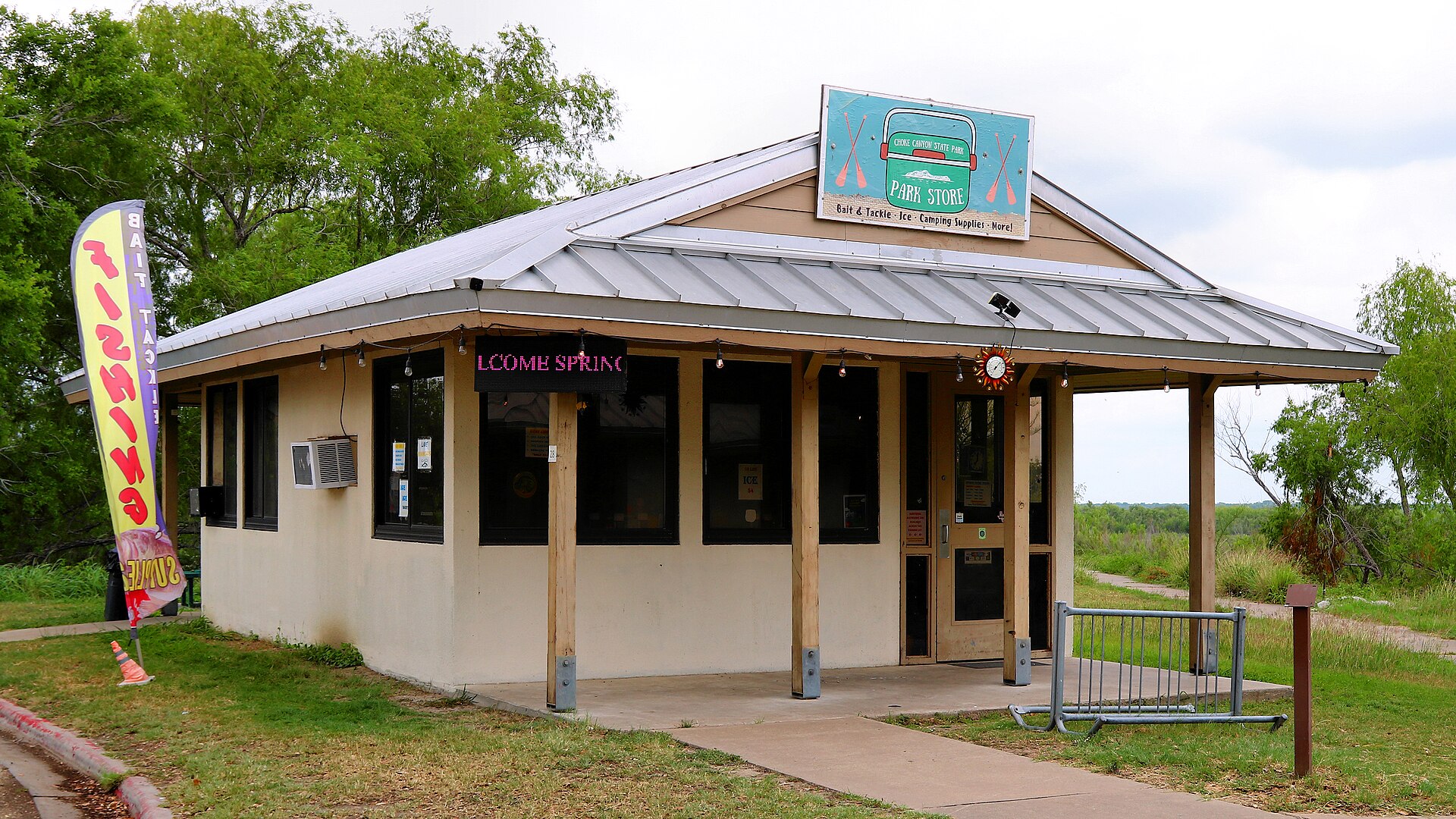
Choke Canyon State Park

A South Texas reservoir state park with two separate public units: full-service Calliham for camping and broader park facilities, and day-use South Shore for boating, fishing and birding.

Best season: Fall through spring for birding, camping and comfortable shore time; fishing remains popular year-roundUpdated Sep 2026
  • Calliham Unit camping, cabins and recreation
  • South Shore day-use fishing, boating and birding
  • Choke Canyon Reservoir fishing
Explore this place
Check current drive from Corpus Christi ↗

About 75 geographic miles

Port Lavaca

Port Lavaca · Calhoun County

Lighthouse Beach

A developed Port Lavaca bayfront park with a beach, birding boardwalk, playground, RV facilities and views across Lavaca Bay.

Best season: March through May and September through November for milder beach weather; summer is busiest and hottestUpdated Sep 2026
  • Protected-bay beach
  • Coastal Bend setting
  • Port Lavaca access
Explore this place
Check current drive from Corpus Christi ↗

About 75 geographic miles

Port O'Connor

Port O'Connor · Calhoun County

King Fisher Beach

A small community beach at Port O'Connor with picnic and recreation amenities, giving visitors a convenient Matagorda Bay shoreline stop near fishing and boating access.

Best season: March through May and September through November for milder beach weather; summer is busiest and hottestUpdated Sep 2026
  • Protected-bay beach
  • Coastal Bend setting
  • Port O'Connor access
Explore this place
Check current drive from Corpus Christi ↗

Farther geographic choices · check if an overnight fits better

13 full TexasDefined guides in this geographic band

About 90 geographic miles

Cuero

Cuero · DeWitt County

Cuero

Cuero is a DeWitt County courthouse town with a historic Main Street district, Chisholm Trail and ranching history, Turkeyfest traditions, multiple museums, murals, a large municipal park and access to the Guadalupe River paddling corridor.

Best season: Spring for wildflowers and mild outdoor weather; fall for Turkeyfest and downtown events when current dates are confirmedUpdated Sep 2026
  • DeWitt County Courthouse
  • historic downtown
  • Chisholm Trail Heritage Museum
Explore this place
Check current drive from Corpus Christi ↗

About 95 geographic miles

Palacios

Palacios · Matagorda County

Palacios Bay Beach

A bayside shoreline stop in Palacios on Matagorda Bay, oriented toward calm-water scenery, family recreation, fishing and the town's long waterfront rather than Gulf surf.

Best season: March through May and September through November for milder beach weather; summer is busiest and hottestUpdated Sep 2026
  • Protected-bay beach
  • Coastal Bend setting
  • Palacios access
Explore this place
Check current drive from Corpus Christi ↗

About 104 geographic miles

Yoakum

Yoakum · Lavaca County

Yoakum Heritage Museum

Discover Yoakum's railroads, Tex-Tan leather industry, tomato-shipping history and the 1912 Elkins–Browning house.

Updated Oct 2026
  • 1912 Elkins–Browning historic home
  • San Antonio and Aransas Pass Railway records
  • Leather Room, saddles and local tannery story
Explore this place
Check current drive from Corpus Christi ↗

About 105 geographic miles

Matagorda

Matagorda · Matagorda County

Matagorda Beach

A long Gulf beach at the mouth of the Colorado River, combining drive-on shoreline, surf fishing and open-coast scenery with nearby dunes, wetlands and Matagorda Bay access.

Best season: March through May and September through November for milder beach weather; summer is busiest and hottestUpdated Sep 2026
  • Open-Gulf beach
  • Middle Gulf Coast setting
  • Matagorda access
Explore this place
Check current drive from Corpus Christi ↗

About 109 geographic miles

Los Fresnos

Los Fresnos · Cameron County

Laguna Atascosa National Wildlife Refuge

A Lower Rio Grande Valley refuge protecting thornscrub, coastal prairie, wetlands and Laguna Madre habitat used by ocelots, aplomado falcons and hundreds of bird species.

Best season: Fall through spring for birding and comfortable wildlife viewingUpdated Sep 2026
  • Ocelot conservation habitat
  • Exceptional Lower Valley birding
  • Coastal prairie and thornscrub
Explore this place
Check current drive from Corpus Christi ↗

About 113 geographic miles

Harlingen

Harlingen · Cameron County

Iwo Jima Museum and Monument

The monument and museum commemorate the Marines associated with the famous flag-raising on Mount Suribachi during the 1945 Battle of Iwo Jima. The site links the Rio Grande Valley to one of World War II's most recognizable images and to the military training history of South Texas.

Updated Aug 2026
  • World War II
  • U.S. Marines
  • Rio Grande Valley
Explore this place
Check current drive from Corpus Christi ↗

About 113 geographic miles

Shiner

Shiner · Lavaca County

Shiner

Shiner is a small Lavaca County town where Czech and German heritage, railroad history, a nationally known brewery, a painted church, local museums and a compact historic core make an unusually strong one-day or overnight Texas road-trip stop.

Best season: Fall through spring for comfortable walking and road-trip weather; brewery tours and the town's core attractions operate year-roundUpdated Sep 2026
  • K. Spoetzl Brewery tours and visitor campus
  • Saints Cyril and Methodius Catholic Church
  • Edwin Wolters Memorial Museum
Explore this place
Check current drive from Corpus Christi ↗

About 114 geographic miles

Edinburg

Edinburg · Hidalgo County

Museum of South Texas History

Museum of South Texas History in Edinburg preserves and interprets the borderland heritage of South Texas and northeastern Mexico through archaeology, ranching, river commerce, railroads, agriculture, military history and Rio Grande Valley community life.

Updated Sep 2026
  • Rio Grande Legacy permanent exhibition
  • 1910 Hidalgo County Jail historic core
  • South Texas and northeastern Mexico borderland history
Explore this place
Check current drive from Corpus Christi ↗

About 114 geographic miles

Shiner

Shiner · Lavaca County

K. Spoetzl Brewery

The historic Shiner brewery is a working production brewery, distillery and visitor campus in Lavaca County, with guided brewery tours, Shiner beer tastings, a gift shop, on-site barbecue, the Rickhouse restaurant and more than a century of Texas brewing history.

Best season: Year-round; spring and fall are especially comfortable for combining the brewery with downtown Shiner and other Lavaca County stopsUpdated Sep 2026
  • Guided working-brewery tour
  • Complimentary Shiner beer pours for guests of legal drinking age
  • K. Spoetzl Distillery and separate distillery tours
Explore this place
Check current drive from Corpus Christi ↗

About 114 geographic miles

South Padre Island

South Padre Island · Cameron County

E.K. Atwood Park

A Cameron County beach access north of town that connects State Park Road 100 to Gulf shoreline and the island's vehicle-access beach corridor.

Best season: October through May for milder weather; summer works for beach days with heat, storms and surf conditions checked closelyUpdated Sep 2026
  • Named public beach-access point
  • Padre Island & South Texas setting
  • South Padre Island access
Explore this place
Check current drive from Corpus Christi ↗

About 115 geographic miles

South Padre Island

South Padre Island · Cameron County

Andy Bowie County Park

A Cameron County Gulf beach park just north of South Padre Island's developed core, with beach access, parking, pavilions, restrooms and RV facilities.

Best season: October through May for milder weather; summer works for beach days with heat, storms and surf conditions checked closelyUpdated Sep 2026
  • Managed coastal park
  • Padre Island & South Texas setting
  • South Padre Island access
Explore this place
Check current drive from Corpus Christi ↗

About 118 geographic miles

Gonzales

Gonzales · Gonzales County

Gonzales

Gonzales is a Guadalupe River town where the first military clash of the Texas Revolution, the 'Come and Take It' story, a broad historic district, museums and nearby Palmetto State Park create a strong history-and-outdoors weekend east of San Antonio.

Best season: Fall through spring for historic walking and park time; early October brings major Come and Take It programming, while summer outdoor visits should be planned around heatUpdated Sep 2026
  • Come and Take It history
  • Texas Revolution
  • Gonzales Memorial Museum
Explore this place
Check current drive from Corpus Christi ↗

About 120 geographic miles

Port Isabel

Port Isabel · Cameron County

Port Isabel Lighthouse State Historic Site

Texas' only lighthouse open to the public, an 1852 brick tower in Port Isabel where 75 winding stairs and short ladders lead to coastal views toward South Padre Island and a restored third-order Fresnel lens.

Best season: Fall through spring for mild coastal weather; summer offers extended hours but greater heat and storm riskUpdated Oct 2026
  • Climb Texas' only publicly accessible lighthouse
  • Third-order Fresnel lens illuminated again since 2022
  • Views toward South Padre Island and Laguna Madre
Explore this place
Check current drive from Corpus Christi ↗

Optional overnight planning

Make a longer trip without rushing home

Some destinations are better with an evening or overnight. Compare nearby hotels and rentals using the existing booking options after choosing your destination; no stay or availability is guaranteed.

See optional hotel and rental choices ↓

Affiliate disclosure: TexasDefined may earn a commission from qualifying booking links, at no additional cost to you. Booking terms and availability come from the provider.

For local visitor businesses

Reach readers planning Texas day trips

Hotels, outfitters, attractions, chambers and travel businesses can request information about disclosed advertising or sponsorship. Editorial destinations and rankings are never for sale; no placement is implied or guaranteed.

Inquire about local travel partnerships →

Before you go

Use geography as a shortlist, then check the real route.

TexasDefined uses location data to make the statewide catalog easier to search. Open the current driving route for the places you are considering, then verify opening hours, reservations, park alerts, water conditions and weather with the current official source.